 |
| Map of Martis Creek Wildlife Area: the social and official trails that branch off from the loop into pine forest and Northstar neighborhoods are not shown on this map |
The
Martis Creek Loop is an easy, 4.1-mile long
round-trip trail around the
Martis Creek Wildlife Area, located between
Truckee and
Northstar, California. For a
nature stroll, you may want to try
Martis Creek Trail, which leads from the Trailhead at Highway 267 (southeast from Martis Dam Road junction) through boggy habitat alongside
Martis Creek to
Pappe's Bridge. From there, you can walk back to the trailhead on the loop trail by either taking the shorter section (continuing clockwise) or the large section (anti-clockwise). The
Tompkins Memorial Trail (
TMT) and the Martis Creek Loop share trail sections. Off-loop trails connect with the
Porcupine Hill area, the Northstar neighborhoods and Martis Camp.
Before presenting hiking suggestions and a few snaphots based on my mid-April hikes in the Martis Creek/Northstar area, I like to start with some notes about the very popular
Martis Creek Trail.
 |
| Martis Creek on a spring day |
Loved to Death?
This question is asked on the “Martis Creek Trail” interpretive board at the trailhead, which tells us that the original trail along the creek was never properly constructed:
It originated as a cattle path and was converted to a hiking trail. Sections of the trail have fallen into the creek, leading to an excessive amount of sediment in the water. This can adversely affect aquatic insects and fish.
The most affected trail sections have been rerouted away from the creek through a cooperative restoration effort. Since this very popular, heavily used trail traverses such fragile habitat, biking the trail is prohibited and visitors are asked to stay off of the old trail sections, avoid the trail when it is muddy and also consider other trail options when bringing dogs during the prime
bird nesting season from May to mid-July.
 |
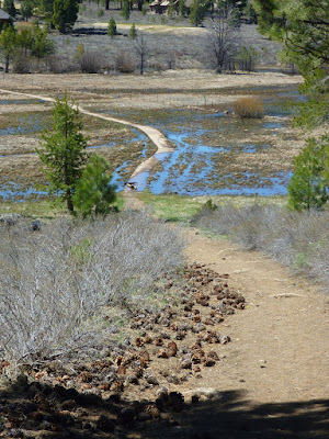
| Tomkins Trail: downhill alongside pine cones and over boardwalk to Pappe's Bridge |
Get your feet wet
So, skip Martis Creek Trail—when really wet—and get your feet wet on the perimeter loop. Early in the season, the loop trail often is partially flooded. As you walk on Tomkins Trail downhill to its junction with Martis Creek Trail, you will arrive at a boardwalk that may partially or completely be under wet snow or meltwater.
 |
| Water-plantain buttercups |
Explore wildflowers
Buttercup flowers
like creeksides and wet meadows. Alongside the trail between Pappe's Bridge and Jake's Bridge I found various patches of
water-plantain buttercups. With their bright yellow, shiny petals, they can't be missed. Less abundant,
Beckwith violets were growing nearby at drier spots between sagebrushes. Each flower was showing its yellow throats below the two dark-purple upper petals.
 |
| Beckwith violets |
Pappe's Bridge
 |
| Martis Creek staff gauge (April 20, 2018) |
Pappe's Bridge crosses Martis Creek. Look out for the staff gauge with its 1/50th foot graduation marks, which allows to measure the water level quite accurately. A picnic table invites you to rest at the creek bank.
Jake's Bridge
Next to Jake's Bridge is a bench with a memorial plaque: Leslee McElroy loved to take her dog, Dusty, to Jake's Bridge and watch him play in the creek. This point is a trail T-junction. Either path alongside the creek will lead you to Jake's Bridge.
 |
| Jake's Bridge and Dusty's pleasure ground |
Take the northeast-leading trail, which is the Tomkins Memorial Trail section, to follow the perimeter loop. Take the southwest-leading path towards Martis Camp if you like to explore a side-loop. Before getting to Martis Camp, you will arrive at an easy-to-miss junction. Take the right branch uphill into the pine forest. The trail bends and meets the TMT (the Y-junction shown below) a short distance away from Pappe's Bridge.
 |
| Y-junction southeast from Pappe's bridge with two options to Jake's Bridge: TMT bends left |


No comments:
Post a Comment