Tuesday, June 30, 2015

2015: A good year for prickly pears in northwest Nevada

Prickly pear cactus with a view in Hidden Valley Regional Park
Prickly pear cactus with a view: from a Hidden Valley slope over Huffaker Hills to Mt. Rose Wilderness/Carson Range
May storms have brought late-season snowfall to the Sierra Nevada and rainfall to northwest Nevada. The Reno-Tahoe area has seen some substantial precipitation during late spring—unusual for the season. This different weather pattern resulted in a flamboyant display of flowering plants. The pictures herein show prickly pear cacti (Opuntia ficus) seen next to trails in Reno's Huffaker Hills and in Hidden Valley Regional Park; southeast of the metropolitan Reno/Sparks area.

The local low-growing variety starts its bloom with pinkish flower buds that open to yellow flowers. The typically paddle-shaped pads are green with medium to long spines.

Prickly pear cactus flower and flower buds
As a frost- and drought-tolerant plant, opuntias make excellent contributions to xeroscaped gardens and parks designed for climate conditions in northern Nevada. The prickly pear cactus is a food plant. Culinary opuntia species have been a staple of the American southwest and Mexican diet for thousands of years. The vegetable-like pads, the salad-enhancing flower petals and the mature fruits—the eponymous prickly pears, also known as tuna—are harvested and eaten. Also, prickly pear species such as Opuntia ficus-indica are plants of many constituents—ingredients—with various pharmacological uses [1].

Prickly pear pads and spines
Spiny pads: prickly pear nopals with spine work
Besides enriching gardens, kitchen tables and apothecary cabinets, productive prickly pear cacti are of interest for bioenergy production. So far in small amounts, Opuntia is used for anaerobic biogas production [2]. If the metabolism of prickly pear plants can be directed to produce lipids or oils rather than mostly carbohydrates, than they have a bioenergy potential for arid regions such as Nevada. Prickly pears require only 20 percent of the water required by traditional crops. Respective research in biochemistry and plant molecular genetics is performed in The Cushman Lab at the University of Nevada-Reno [3,4].

In future, you may encounter prickly pears not only as indivual plants next to your favorite desert trail, but in cultivated communities across an agriculturally expanding desert.  

Keywords: wild opuntia, cultivated opuntia, food source, pharmacology, agronomy, renewable energy, biodiesel, bioengineering.

References  and more to research
[1] Sigma-Aldrich: Nopal (Opuntia ficus-indica) [http://www.sigmaaldrich.com/life-science/nutrition-research/learning-center/plant-profiler/opuntia-ficus-indica.html]
[2] Bruce Dorminey: Prickley Pear Cactus: Nuisance of Bioenergy Opportunity? Renewable Energy World.Com, Tuesday, June 30, 2015 [www.renewableenergyworld.com/articles/2014/01/prickly-pear-cactus-nuisance-or-bioenergy-opportunity.html]
[3]  UNR Reserches Sustainable Alternatives to Fossil Fuels. The Nevada Sagebrush. Tuesday, February 4, 2014; page A1.
[4] Nevada Agricultural Experiment Station: Development Of Prickly Pear Cactus As A Low-Water Biofuel/Biomass Feedstock [www.cabnr.unr.edu/research/research_project.aspx?GrantID=705].

Wednesday, June 24, 2015

Wind-driven smoke and growth of the Washington Fire

Washington Fire near Markleeville, Alpine County, California
Washington Fire: a cloud of thick smoke seen from above Red Lake near Carson Pass in the Sierra Nevada
On Sunday, June 21, 2015, I was heading with friends toward Carson Pass. We were wondering, if this was the right day for a Pacific-Crest-Trail hike to Showers Lake, since strong winds blew over the Sierra. While driving south from Minden, Nevada, toward California, we saw a train of smoke moving eastward from the Markleeville area (Alpine County) toward the Pine Nut Mountains: the Washington Fire, as we later found out. An electronic highway sign announced that California State Highway 4 to Ebbett's Pass—another Pacific Crest Trail access location—was closed.

We continued on Highway 88 to Carson Pass and had a pleasant hike to Showers Lake via Meiss Meadows. The dry air granted crisp views of the volcanic rock formations and lava domes within the Carson Pass area. Driving home, we saw the further evolving Washington Fire by scanning the eastern mountain ranges of the Sierra Nevada from Highway 88 above Red Lake. The thick red-gray smoke could have been taken as the result of an volcanic eruption. But we already knew from emergency alerts on the radio that this was a blaze.

It was ignited by a lightning strike and stoked by strong erratic winds. By Tuesday, the fire was contained by less than 10 percent. According to the Reno Gazette-Journal it has increased to 16,500 acres:  Residential areas, historic cabins and campgrounds near Markleeville as well as local sight-seeing landmarks are currently off limits:

Highway 89 over Monitor Pass remain closed at U.S. 395. California Highway 4 is closed, and Turtle Rock and Indian Creek campgrounds are shut down. All visitors and campers from Wolfcreek to the top of Ebbitts Pass [? new spelling of Ebbett's Pass or Ebbetts Pass] have been evacuated. Markleeville remained on standby for possible evacuation.

I am not able to figure out why this fire is called Washington Fire. The little town of Washington, California, is located in Nevada County.  So, what is the little something in Alpine County after which this fire has been named? Or am I on the wrong track?

Keywords: wildfire, fire growth, severe drought conditions, evacuation, fire nomenclature.

Reference
Staff and wire reports: Little containment as fire chars 16,500 acres. Reno Gazette Journal, Wednesday, June 24, 2015, pages 1A and 5A.

To Showers Lake via PCT from Meiss Meadows Trailhead

Showers Lake, Sierra Nevada
Showers Lake with hanging meadows and cliff-castle

Showers Lake belongs to a group of subalpine lakes and lakelets between Carson Pass and Echo Summit in the Upper Truckee River drainage area of the Sierra Nevada south of Lake Tahoe. These lakes are visited for trout angling, swimming or simply for the panoramic views from the lake sites as well as the meadows and paths between and beyond. Numerous campsites can be found between boulders and conifers around the lakes. On warm summer days, the more accessible lakes, including Showers Lake, can be crowded with both day-visitors and campers. Everyone seems to enjoy this inspiring Sierra lake district and its trails in Meiss County, California [1-3].

From the Meiss Meadows Trailhead northwest of the Carson Pass Information Center (Highway 88), the northbound Pacific Crest Trail (PCT)—open for hiking and horseback riding—ascends through a forest of pines, junipers, aspens and scattered boulders. Once the single-track trail leaves the forest, it further ascends across an open slope upward to a scenic saddle, iris-covered during early summer. Here, you will have southward views of The Sisters, Round Top and the Elephants Back.lava dome. Continuing north, Lake Tahoe comes into view. Then, the PCT winds down into Meiss Meadows and towards the historic Meiss Cabin, where once the Meiss family spent the summer months fishing, cattle ranching and enjoying snow-bank-frozen ice cream. 
Trail sign near Meiss Family Cabin, Sierra Nevada
Distances from PCT/TRT junction

At the trail junction near this historic cabin & stable site, where the Tahoe Rim Trail (TRT), coming from Round Lake, merges with the PCT, a sign shows the distances for northbound travelers: 2 miles to Showers Lake, 6 miles to Bryan Meadow and 10 miles to Echo Summit. For a while, the level PCT continues between stands of light forest and meadows. Seasonal trickles or low streams have to be crossed.
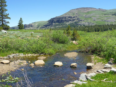
Pacific Crest Trail in Meiss County
PCT between Meiss Cabin and Showers Lake: stepping stones in front, the volcanic rock formations east of Round Lake in the background

The trail then ascends toward a forested crest, from which Showers Lake comes into view. After a short descend you will reach the south corner of the lake, where deep mud and dense willows may keep you away from the shore. Most areas around the lake, however, feature needle-covered ground in the shade of pine trees and mountain hemlocks. Tim Hauserman puts it this way [4]:

Showers Lake itself is beautiful (although often crowded with campers). The south side is marshy but the northern side provides great swimming opportunities enhanced by flat granite rocks that reach down to the water. Several camping spots surrounded by hemlock, lodgepole pines, and before summer, mosquitoes, can be found above the north and east sides of the lake.

When we were there on June 21, 2015, a strong wind was blowing, keeping the mosquitoes away.

In topographic maps, the Showers Lake basin is given an elevation of above 8,500 feet. There are various paths crisscrossing the half-bowl-shaped basin landscape. The PCT itself passes alongside the northern shore. It continues down below the lake's outlet and then heads up and out of the forest to higher points from where Dardanelles Lake, Lake Tahoe and Freel Peak can be seen.  

References and more to explore
[1] Carson Pass to Showers Lake: sites.google.com/site/zbjohnsonadventures/hikes/california-nevada/showers-lake.
[2] Flowers create colorful path to Showers Lake: tahoesouth.com/blog/showers_lake_hike/.
[3] Showers Lake 2003: www.avidbackpackers.com/htm/trips/show.htm.
[4] Tim Hauserman: The Tahoe Rim Trail. Wilderness Press, Berkeley, California, 2002.