Friday, December 28, 2018

Around the Nevada “N”-—the Thorton Point Loop


Thorton Point: view of downton Reno, Huffaker Hills and Virginia Range
The Thorton Point Loop is a round trail within the section of Rancho San Rafael Park stretching into the Peavine Mountain foothills north of N McCarran Blvd. This is a popular hiking and mountain biking area just a few miles away from the campus of the University of Nevada, Reno (UNR). UNR students maintain and paint the rocks that form the hillside letter_“N” with its slab serifs.
 Nevada “N” —slab-serif-typefaced
“N” trail signRecently, I noticed the trail-map entryThorton Point Loop 4.0 mi” in the Evans Canyon Trailhead map displayed at the kiosk in the Reno Softball Complex/Disc Golf Course parking area. Older maps just show(ed) Thorton Point (if at all). Anyway, walk from the trailhead to the Basque Sheepherder Monument and you will see the “N” slope with the Thorton Point rock outcrops crowning the Nevada “N” site. From the monument, hike downhill to Evans Canyon grove where a Nature Trail circles through the tiny forest alongside creek banks. Cross Evans Creek and go upward on Miners Canyon Trail/ “N” Trail leading to the “N” site. Before getting to the letter baseline, turn right at the intersection you can see in the upper section of the picture below.
“N” Trail
Upward to the Nevada “N” and Thorton Point

Mizpah mine tailings
Pass the tailings of the Reno Mizpah Mining Co. site (in the small canyon to your right).
Continue ascending to the fenced-in NV Energy high-voltage facility. At the trail intersection next to the hazardous voltage site, turn left onto Reno Vista Trail. This trail traverses the area between the “N” and Thornton Point.


Thorton Point red rock with lichen and snow
Eventually, the vista trail bends left and descends to its junction with the Rancho Connector Trail (RCT). Continue downhill on the RCT into Coyote Canyon, ending at the Evans Canyon grove. From there, it only is a short distance to the Basque Monument and your starting point.

Trail Maps

Map showing four-mile-long Thorton Point Loop trail (displayed at Evans Canyon Trailhead kiosk):
Nevada “N” and Thorton Point


“Peavine Trails” map: https://www.reno.gov/home/showdocument?id=48300.
Find Thorton Point and the“N” in the lower right quadrant of this map. The Thorton Point Loop can be identified by following, clockwise, a section of  the Rancho Connector Trail, Reno Vista Trail, “N” Trail and Miners Cyn Trail.

Sunday, October 28, 2018

Olmstead Loop Trail

Olmstead Loop: a horse trail (also used by hikers, dog walkers and mountain bikers)

The Auburn State Recreation Area (ASRA) with the Olmstead Loop Trail is a trail el dorado in El Dorado County, California.

The Olmstead Loop is a nine-mile-long round-trip trail through the Sierra foothills between Highway 49 and the North Fork American River west of the community of Cool. The trail was named in 1993 for outdoor enthusiast and mountain biker Dan Olmstead, who owned and operated the Bike & Hike Shop in nearby Auburn.

Kiosk with Auburn State Recreation Area map
The “official trailhead”—the 0-mile point—of the loop trail is located at the St. Florian Court/Hwy 49 junction. The parking lot, equestrian staging area and an information kiosk with a trail map and a biographical sketch of Dan Olmstead are all located behind Fire Station 72 (proudly serving the Community of Cool). The Olmstead Loop Trail can also be accessed from the Cave Valley Gate at the Northside Elementary School about two miles south of Cool and the Catecroft Gate (Gate 158 near the Niegel Lane/Hwy 49 junction) about three miles south of Cool.

Olmstead Loop Trail
Olmstead Loop Trail near its junction with Cave Valley Trail
The section of the Olmstead Loop Trail that runs close and parallel to Hwy 49 passes through meadows with stands of oak and pine trees and a few blackberry patches. The section halfway between Hwy 49 and the North Fork American River includes two steep canyon descents/ascents: Knickerbocker Creek and Salt Creek. On a hot summer day, you certainly will welcome the shade and water you can find there (before the creeks may dry out in late summer).

The first three miles (if starting in Cool) take you to a line of four radio towers. Soon after passing the 3-mile post the trail bends north. Find the beautiful trail intersection, at which the Catecroft Trail (a shortcut from Gate 158) and the Luken's Mine Trail meet the loop trail. On your way to the westernmost point of the loop near McElroy's Spring, you will pass the 4-mile post.  Past the spring the trail soon descends into Knickerbocker Creek. Between the latter and Salt Creek you will cross a paved road. Instead of continuing the loop route, here you get the chance to shortcut and head east: back to the Cave Valley Gate or northeast to the fire station.

Reach the mile-6 post shortly before crossing Salt Creek. The twenty to thirty minute climb out of Salt Creek canyon on a dirt road gets you to the mile-7 post and the northwest tip of the loop. This is the Pointed Rocks area. Lichen-covered outcroppings of various size point towards the sky. The Training Hill Trail connects this place with the Western States Trail and the Wendell T. Robie Trail. To now conclude the loop (back to the fire station), it takes less than two miles—the last half mile or so with Cool in view.


References and more to explore

[1] Olmstead Loop Trail, description and trail map: https://www.canyonkeepers.org/tgolm.pdf [accessed Oct. 28, 2018].
[2] Jordan Summers: 60 Hikes within 60 Miles of Sacramento. Menasha Ridge Press, Birmingham, AL, 2008.; Hike 34, pp. 182-186.
[3] Ogre's Trail Guide to Northern California Mountain Biking > Olmstead Loop (Cool): ogrehut.com/trails.php/Sierra-Central/Cool/ [accessed Oct. 28, 2018].
[4] Cool Horse Trails > Olmstead Loop (part of the Auburn State Recreation Area): www.coolhorsetrails.com/olmstead_8.html [accessed Oct. 28, 2018].

Monday, July 30, 2018

Lily Lake to Susie Lake

Susie Lake with snow-covered parts of the Crystal Range in the far back
The trail from Lily Lake to Susie Lake is very popular with day-hikers and backpackers alike. Tourists and day-hikers may just walk to the Glen Alpine Springs Historical Site or continue to Grass Lake—a 2.7-mile-hike from Liky Lake (one-way). Climbing up to Susie Lake, Half Moon Lake or Mt. Tallac also are day options.

To get to Susie Lake, follow Glen Alpine Trail from the trailhead at Lily Lake to its junction with Grass Lake Trail. Proceed on the 1.8-mile-long section of Glen Alpine Trail (Trail 17E08 in the map below) to the junction with the Lake Aloha/Gilmore Lake trail post. Up to this point the route is the same as described for the Half Moon Lake hike.

Pond with lily pads next to Trail 17E32

trail post at 17E32/PCT-TRT junctionVeer left at the Lake Aloha/Gilmore Lake junction to follow the Lake Aloha direction (Trail 17E32 in the map). After passing various lily ponds, you will soon arrive at the 17E32/PCT-TRT junction (trail post shown on the left). Turn left (southwest) and descend to a beautiful meadow, which is densely covered with wildflowers including alpine tiger lilies. The first Susie Lake overlook is coming up soon. The PCT-TRT makes a half-circle around Susie Lake and then continues westward to Heather Lake and Lake Aloha. Susie Lake's shore allows for stunning views of Cracked Crag and Jack's Peak.


Maroon-spotted flowers of alpine tiger lily
 
Map of Susie Lake and surrounding lakes and trails including Half Moon Lake Trail (17E31)

More to explore about and around Susie Lake

Thursday, July 26, 2018

Half Moon Lake Trail (17E31)

Half Moon Lake backdropped by Dick's Peak
The level, switchback-free path to Half Moon Lake is a single-track trail within the Desolation Wilderness passing granite-based ponds and lakes surrounded by stunning mountain peaks. The beginning section of the two-mile-long Half Moon Lake Trail (17E31) runs parallel—but at lower elevation—to the Tahoe Rim Trail/Pacific Crest Trail (TRT/PCT) between Gilmore Lake and Dick's Pass. Trail 17E31 then loops around the north side of Half Moon Lake and ends at the smaller Alta Morris Lake. These two subalpine lakes lie just below the treeline at the foot of imposing Dick's Peak (9,974 ft, 3040 m) and Jack's Peak (9,856 ft, 3004 m).

Although Half Moon Lake Trail (HMLT) is a pleasant treat, to do this hike you first need to get to the four-way intersection where Glen Alpine Trail meets the TRT/PCT—half a mile south of Gilmore Lake. This is where the HMLT begins.
Glen Alpine Soda Spring at historical site

The shortest way up to the TRT-PCT/Glen Alpine/Half Moon Lake trail intersection is from the Glen Alpine trailhead. After filling out your day-use permit and box-dropping the requested part, start out on the gravel trail via the Glen Alpine Springs Historical Site toward Grass Lake.

At the Grass Lake Trail junction, continue on Glen Alpine Trail (following the Mt. Tallac direction). This trail ascends for 1.8 miles to another junction, from where two short trails connect with the TRT/PCT: the left-side trail leads to Susie Lake and the right-side trail ascends toward Gilmore Lake and Dick's Pass. You want to take the latter.

Lily pond near four-way intersection
After a short climb you will pass a lily pond overlook point and then soon reach the four-way intersection, at which the HMLT begins.   

Four-way intersection
Enjoy the easy hike along 17E31 through a forested area with occasional views of Crystal Range peaks in the south. On July 24 of this year, when I hiked this trail, the air quality was not the best. But the light-gray silhouette of Pyramid Peak and a white band of snow alongside the north-facing wall of Crystal Range did show up at the horizon.

Half Moon Lake Trail (HMLT) through forested area
Just before arriving at the eastern tip of Half Moon Lake, you will see a couple of little lakes (which I can locate on my map, but which I am unable to identify by name).

One of the unnamed little lakes

Half Moon Lake

Map of Half Moon Lake and Alta Morris Lake with nearby Dick's Peak and Jack's Peak
Does anyone know how the trail label 17E31 came about? Is there a deeper meaning to it? I prefer the trail acronym HMLT that I made up for this this post, which may have been used by other writers as well.

Waterfall above Half Moon Lake


Saturday, July 14, 2018

Tahoe Meadows to Herlan Peak

Granite cliff rocks on Herlan Peak with views toward the south of Lake Tahoe
About halfway between Tahoe Meadows and Spooner Summit, the Tahoe Rim Trail (TRT) traverses the forested east-side slopes of Herlan Peak. The Tahoe Meadows-Herlan Peak round trip distance is almost 25 miles (40 km). I hiked this trip in June of this month. Both the scenic Twin Lakes and the Sand Harbor Overlook with its unforgettable vistas of Lake Tahoe and the Sand Harbor Peninsula at the bottom of Herlan Peak are worth the trip.

Being at Tahoe Meadows and not sure about a 25-mile-long hike? You don't have to do that one. Exploring the beautiful Tahoe Meadows Interpretive Loop Trail with its hidden picnic bench or the Tahoe Meadows Loop Tail System may be a pleasant alternative: strolling alongside clear brooks and around wetlands surrounded by sandy hills and pine forest. 

Back on the TRT. This Carson Range TRT section is very popular with mountain bikers. The 9.5-mile-TRT-stretch between Tahoe Meadows and the TRT/Tunnel Creek Road intersection is open to bikes on EVEN days. This north-south section is a mostly gentle trail through pine and fir forests with openings offering views of Lake Tahoe on the west side and Washoe Lake on the east side.

Washoe Lake seen through an opening near Diamond Peak
You will pass the top of the Diamond Peak Ski lift after about five miles from the Tahoe Meadows trailhead. After continuing southward for another two miles, the trail makes a long, descending switchback through pinemat manzanita and chinquapin. Once you have reached the bottom of the downhill path, you will enjoy a relaxing section along the TRT to its intersection with Tunnel Creek Road.

The shallow grass-lined Twin Lakes are located 0.3 miles south of Tunnel Creek Road. Some years, they are dried up by the end of summer and all that is left are boulder-strewn pond beds. 

Upper Twin Lake
Past the eastern tip of Lower Twin Lake, the TRT switchbacks up onto Herlan Peak for “never-ending” 1.5 miles. I saw a lot of cyclists hoping off their bike and pushing. Once you get the sign saying “Sand Harbor Overlook Loop 0.6 Mile,” leave the TRT (and your bike) and make the final steps to the top of Herlan Peak.


Sand Harbor Overlook Loop trail is also known as Christopher's Loop spur view trail—or simply Christopher's Loop (see map below). This 1.2-mile loop trail leads you to the Herlan granite cliff with its spectacular views of Lake Tahoe—and also of Marlette Lake and Snow Valley Peak. If not yet tired, you may want to test your Pacific Crest knowledge by pointing out and naming the peaks and saddles lining the horizon across Lake Tahoe.

Sand Harbor Overlook trail on Herlan Peak

Marlette Lake with Snow Valley Peak seen from Herlan Peak

Looking down from Herlan Peak: tip of the Sand Harbor Peninsula with recreational boat traffic


Getting to the Tahoe Meadows TRT trailhead

To get to the TRT trailhead at Tahoe Meadows, find the parking and rest area half a mile southwest from the Mt. Rose Summit parking area along State Route 431 (Mt. Rose Highway). The TRT passes right through the parking lot. Start at the interpretive board, where trail-map hand-outs are frequently made available. For a short distance, the TRT almost merges with State Route 431, but then veers off to the left. Very soon you'll reach a bridge over Ophir Creek, where the Lower, Middle and Upper Loop Trails intersect. Once you have reached the saddle above Ophir Creek with the first view of Lake Tahoe, you should not have any problems in following the TRT—with occasional TRT marks fixed on the bark of a tree.

Map section with TRT (green) and Tunnel Creek Road (black) in the Twin Lakes-Herlan Peak area


Sunday, June 24, 2018

A short, moderate hike to a great waterfall: Horsetail Falls

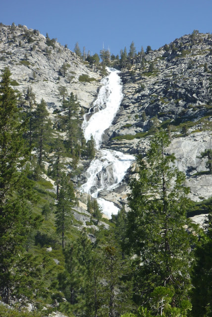
Horsetail Falls, El Dorado County, California
Dropping down a granite headwall: Horsetail Falls  
Horsetail Falls is a series of spectacular waterfalls of the horsetail type plunging down Pyramid Creek in the Desolation Wilderness of El Dorado County, California. The Pyramid Creek Loop Trail is the path to take. Once you have reached the Wilderness Boundary at the northern tip of the loop trail, the half-mile path to the waterfall base is not well-marked. You have the choice of approaching the base by rock climbing between boulders or by following the stream bed. Slippery rocks or rushing water, especially early in the season, may turn the hike into a challenge. Otherdays, the hike is easy—always with the view of your goal, the white stream of cascading water, ahead of you.

Horsetail Falls taming its plunge at the base 
Due to the popularity of this wilderness getaway, you almost never are alone. Don't be surprised to find outdoor enthusiast in beachwear (or less) sunbathing on the canyon ledges at the bottom of the waterfall.

There is a cross-country route up across the polished bedrock to Avalanche Lake and the Lake of the Woods area. Mike White writes that “only skilled off-trail enthusiasts should contemplate this route” up the canyon toward Desolation Valley [1]. 

Top steps of Horsetail Falls
According to a World Waterfall Database entry, Horsetail Falls “consists of 6 distinct steps totaling 791 feet [241 meters]  in vertical drop.” Spring-water volume flow rates peak between 100 and 250 cubic feet per second (cfs), but a record of 2,900 cfs (82.1 m3/s) was reached in 1994 [2].

Pyramid Creek canyon at the bottom of Horsetail Falls


References

[1] Mike White: Afoot & Afield - Reno-Tahoe. Wilderness Press, Berkeley, CA, 2nd printing 2008; page 230.

[2] Horsetail Falls. World Waterfall Database. Link: https://www.worldwaterfalldatabase.com/waterfall/Horsetail-Falls-405.

Sunday, June 10, 2018

Pyramid Creek Loop Trail

One of the unnamed Pyramic Creek waterfalls next to the loop trail  (June 3, 2018)

The Pyramid Creek Loop Trail is your trail loop to access the Desolation Wilderness boundary and nearby Horsetail Falls—a waterfall named for its series of waterfalls of the horsetail type.

The distance from the Pyramid Creek Trailhead to the beginning of the loop is about half a mile. If you decide to hike the loop counter-clockwise, you will reach The Cascades viewing point after a quarter-mile climb. This is a spectacular site, especially during springtime. Here, the water of Pyramid Creek slides down over solid granite.

The Cascades
From the Cascade Vista the trail continues over rock slabs and through scattered forest, never far away from the twisting course of Pyramid Creek. While you climb up the canyon and eventually veer away from the creek, you will enjoy amazing (over)views of the stepped granite headwall with Horsetail Falls cascading downwall in stages through the granite cleft. Keep the waterfall ahead of you, and you will not get lost.

Looking north over a rock slab with Horsetail Falls still at a distance

At the wilderness boundary, you are asked to self-register for a day-use permit. Unclear in places, the trail either follows the riparian creek canyon or leads around granite blocks and over rock slabs. Keep scrambling up the slopes to the base of the waterfall—browsing over the glacier-carved granite faces in front of you. Find your spot to rest, relax and listen to the roaring water.

At the base of  Horsetail Falls

Map of Pyramid Creek Loop Trail including The Cascades


Getting to the Pyramid Creek Trailhead

The trailhead is located next to Highway 50, less than seven miles west of Echo Summit. The trailhead parking lot is well-marked. The parking fee for a day currently is $5.00.


References and more to to explore

[1] Pyramid Creek Cascades, El Dorado County, California, United States. World Waterfall Database.   Link: www.worldwaterfalldatabase.com/waterfall/Pyramid-Creek-Cascades-7183.

[2] Rick: Horsetail Falls: A challenging hike to an imressive waterfall. CalEXPLORnia, August 11, 2014. Link: www.calexplornia.com/horsetail-falls-a-challenging-hike-to-an-impressive-waterfall.

[3] Stephen Berei: Watch your step hiking Horsetail Falls. Lake Tahoe All Access, May 25, 2013. Link: stephenberei.wordpress.com/2013/05/18/watch-your-step-hiking-horsetail-falls.

Wednesday, May 30, 2018

Townsend's big-eared bats at Kentucky stamp mill

General bat anatomy displayed on a board in the Kentucky Mine Historic Park: the distinct Townsend's big-eared bat has horseshoe-shaped lumps on the nostrils and long ears joining at the base
The stamp mill at the Kentucky Mine Historic Park in Sierra City, California, hosts a maternity colony of Townsend's big-eared bats (Corynorhinus townsendii)—a cave-dwelling species that occasionally roosts in man-made structures. The bats of the Kentucky colony have acclimated to local conditions tolerating a certain level of disturbance such as human spectators and short exposure to stamping noise, happening for short times while demonstrating the function ore-crushing stamps to visitors.

Townsend's big-eared bats are named for their extremely long and flexible ears. But there is more in the long common name. The species name—also the shorter scientific name—commemorates the American naturalist and collector John Kirk Townsend (1809-1851), who, in the first half of the 19th century, explored the wildlife between the Rockies and the Pacific Ocean [1]. Various subspecies are found throughout western North America between British Columbia and Mexico.

Corners and crevices of the stamp mill at the historic Kentucky Mine serve as roosting sites for Townsend's big-eared bats
Corynorhinus townsendii is protected under the California Endangered Species Act [2]. Threats include habitat destruction and potential introduction of the white-nose syndrom. Although once created by humans for a noisy business, the Kentucky stamp mill is a a safe refuge for this endangered bat species. A tour guide at the mine park informed me that the “Kentucky stamp mill bats” do not migrate. Townsend's big-eared bats prey on moths but may include some other insects in their diet: They (and also other bats) offer natural pest control by eating insects that may otherwise attack crops or forest land.

Female Townsend's big-eared bats rear their young in maternity colonies. A handout provided at the Kentucky Mine Museum in the Bigelow House describes their mating and breeding cycle:

Mating begins in the fall and continues through the winter. Townsend's big-eared bats have delayed fertilization, storing sperm until ovulation occurs in the spring. In March or April the females begin to form maternity colonies, where theyr rear their young. During the maternity season, males remain solitary or form small bachelor groups. The length of gestation varies depending on the climate, but generally lasts between 56 to 100 days. Females give birth to a single young, called a pup. The babies develop rapidly: they are able to fly by three weeks, nearly grown by four weeks and weaned by six weeks. Females return to the same roost where they were raised to give birth to their own young. Males and females spend the winter together to hibernate.


References and suggested reading

[1] Bo Beolens, Michael Watkins and Michael Grayson: The Eponym Dictionary of Mammals. The Johns Hopkins University Press, Baltimore, Maryland, 2009; page 416.

[2] Noah Greenwald: Townsend's Big-eared Bat Protected Under California Endangered Species Act. Center for Biological Diversity, June 27, 2013. Link: www.biologicaldiversity.org/news/press_releases/2013/townsends-big-eared-bat-06-27-2013.html.

[3] Gary M. Feller and Elizabeth D. Pierson: Habitat Use and Foraging Behavior of Townsend's Big-Eared Bat (Corynorhinus Townsendii) in Coastal California. Journal of Mammology, February 2002, 83 (1), 167-177. Link: https://academic.oup.com/jmammal/article/83/1/167/2372774.  

Monday, May 28, 2018

Kentucky Mine Historic Park


Trestle top entrance for ore cars (and now visitors) into Kentucky Mine stamp mill

The Kentucky Mine Museum and Historic Park opened over the Memorial Day Weekend to kick off its 2018 season. I joined the Sunday morning hour-plus tour to see the inside of the stamp mill. The staircase walk down inside the stamp mill is the highlight, but during the tour one also gets access to the Kentucky Portal and a replica of a miners cabin. I really enjoyed to hear the local mining history as told by the tour guide, who also demonstrated how the displayed tools—mining as well as household tools—were used during the gold-mining days.

Kentucky Portal and replica of a miners cabin
Display sites of mining equipment and buildings are connected by paved trails or gravel paths. Next to the beginning of the trestle railway is a bench inviting you to rest awhile in memory of David Eugene Smith (1948-2013), a gold miner and storyteller. From there, you will have an excellent view of the Kentucky Portal, the miners cabin and an old trommel in the middle of the “plaza” between cabin and stamp mill.

trommel for gold mining
Trommel with miners cabin in background
Our tour guide and her daughter performed snake-checks before letting us enter the portal in front of the adit and the multiple-floor stamp mill. Inside the portal, we got to see an operating pelton wheel. I was surprise how fast it was spinning and got sprinkled with water while coming close to it. The adit is connected with the upper floor of the stamp mill by rail, on which ore cars where transporting ore over the trestle into the hopper room above the grizzley to dump the rocks. From there, the downfall and downbreak of the rocks of various sizes into smaller pieces began. They were passing the jaw crusher and ending up at the bottom, where the pieces were finally powderized under stamps. Two five-stamp settings are there to do the job. We walked down the stairs, floor by floor, to explore the technical details including the well-preserved belt system, bull wheels and the cams and eccentrics that raised and dropped the stamps. The stamp system still works and was demonstrated to us by manually pulling the associated pelton wheel. The stamp mill operated during times, when mercury was still in use here to separate the gold from milled ore.

Next to the stamp tables, on which gold was separated from the crushed quartz and rocks by amalgamation (alloying), is an exit door. Before leaving the stamp mill, I looked up one more time, to spot some of the Townsend's big-eared bats roosting in corners high above wheels and belts.

Asking final questions, members of the tour group exited the mill.  Now, everyone was on his or her own again to check for snakes. Visitors not encountering a snake on the grounds may be interested in seeing the rattlesnake decorating a clampers antique hat on display in the museum.

Sign on Highway 49 for Kentucky Mine Historic Park

Museum

The small, awe-inspiring museum is part of the Bigelow House, a replica of a 19th century hotel.

Location

Find the park & museum at the end of Kentucky Mine Road, a short incline off the Golden Chain Highway (Hwy 49) between Bassetts Station and downtown Sierra City:

100 Kentucky Mine Road
Sierra City, CA 96125

$1 museum admission and $7 tour fee for adults (free for children 6 and under, $3.50 for children ages 7-17).

Kentucky Mine Stamp Mill with trestle

References and more to explore

[1] Kentucky Mine Historic Park & Museum. National Geographic - Sierra Nevada Geotourism.  Link: www.sierranevadageotourism.org/content/kentucky-mine-historic-park-amp-museum/sie9339b2a13f3daefe1.
[2] Kentucky Mine and Museum. Backcountry Explorers. Link: www.backcountryexplorers.com/kentucky-mine-museum.html.