Saturday, July 9, 2011

Brown's Peony north of Lake Tahoe

Brown's  peony (Paeonia brownii) is a flowering plant of western North America, therefore also called western peony. This plant grows in sagebrush desert and pine forests, typically on sandy soils and clay soils [1-3]. The plants shown here were found at a particular semi-shade area along the Tahoe Rim Trail between Brockway Summit and the branch-off to Martis Peak.

Brown's peony is a leafy plant with bluish-green, divided leaves. The flowers are multicolored. They show a deep purple color, while they are closed. The blossoming flowers have five to six purple-greenish petals, looking like upside-down spoons in the hanging flower of the picture just above. Towards the center, the flowers turn orange and yellow, exposing a cluster of yellow-green miniature bananas, which are thick-walled follicles that hold the seeds [4]. The hermaphrodite peony flowers are pollinated by insects.

Northwestern Native Americans made tea from western peony's roots to treat lung ailments [3]. And a powder of the dried and ground root can be used as a dressing on cuts, wounds, burns and sores [1].

References and further reading
[1] Plants for a future: Paeonia brownii - Douglas [www.pfaf.org/user/Plant.aspx?LatinName=Paeonia%20brownii].
[2] Peter Alden and Fred Heath: Field Guide to California. National Audubon Society, Chanticleer Press, 1998; page 161.
[3] Richard Spellenberg: North American Wildflowers. Alfred A. Knopf, New York, 2001.
[4] California Wildflowers: Brown's Peony, Paeonia brownii (Paeoniaceae)  [researcharchive.calacademy.org/research/botany/wildflow/wildflowers.asp?w_id=128].

Friday, July 8, 2011

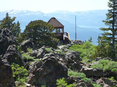
Martis Peak Fire Lookout

A visit to Martis Peak Lookout is suggested as a sidetrip in Tim Hauserman's Tahoe Rim Trail book [1] and as Trip 1 of the North Tahoe hikes in Mike White's guide Afoot & Afield [2]. For hikers, the best way to get to Martis Peak is probably from the “intersection” of the Tahoe Rim Trail (TRT) and Highway 267 between Truckee and Kings Beach. The eastward TRT section connects the Brockway Summit with the Mt. Rose Summit, a distance of 19.7 miles according to the hand-outs available at the trailhead orientation panel. Martis Peak is five to six miles away, with about one mile off the TRT.

During early July this year, some trail sections near Martis Peak were still hidden under piles of snow. We met some bikers who gave up at the final section. After skirting a meadow with southwest views of Lake Tahoe and the Sierra Nevada, the TRT merges with a dirt road. While the TRT continues to the east, the trail to Martis Peak continues westward on this road (for a short distance) and then north on a paved road (16N92B), currently blocked by a fallen tree (see picture), which hikers easily bypass. After about half a mile, the wooden fire lookout building (restored through the cooperative efforts of USFS, CDF and the community) is coming into view. Assuming no fires and good weather conditions, the lookout panorama includes Mt. Rose, Mt. Verdi, the Boca and Stampede Reservoirs, Donner Lake and Pass, the mountain ranges of the Granite and Desolation Wilderness and Lake Tahoe.   

Getting to the TRT parking area at Brockway Summit
From Interstate 80, take Highway 267 south to Kings Beach. Drive through eastern parts of Truckee, pass the airport (to your left) and the Martis Creek Wildlife Area (to your right). After passing the Northstar and Ritz-Carlton turnoffs to your right, you get to Brockway Summit. The TRT crosses Highway 267 a little further downhill, where roadside parking is available.


References
[1] Tim Hauserman: The Tahoe Rim Trail. Wilderness Press, Berkeley, California, 5th printing March 2004; page 104.
[2] Mike White: Afoot & Afield • Reno-Tahoe • A comprehensive hiking guide. Wilderness Press, Berkeley, California, 2nd printing November 2008; pages 105 and 106.
[3] Martis Peak: www.summitpost.org/martis-peak/153510.

Wednesday, July 6, 2011

A blue-belly's blue belly


The western fence lizard (Sceloporus occidentalis) lives in almost every part of California and Nevada and in certain areas of the neighboring states. Males show bright blue patches or lines along the sides of the body [1-3], which are best seen when the lizard turns around—what he never does. While I was watching a western fence lizard in the upper Hunter Creek area west of Reno in Nevada, a friendly hiker came along, carefully picked up the lizard and turned him around: the above picture shows the blue belly and his yellow-orange limbs. The picture below shows the typical angle of view, which we have, when encountering lizards. The skin with coarse, spiny scales of this male lizard, exhibiting patterns of light and dark brown triangular polyominoes on a grayish white background, can be seen.


The western fence lizard is normally not found in the desert, maybe in desert canyons. Its preferred habitats include the ground, rocks and lower parts of coastal sage brush, chaparral and woodlands—from the Pacific coast (a disjunct population occurs on Isla de Cedros off of  Baja California [2]) to high elevations below 9,000 feet like the Lake Tahoe area. Its diet includes spiders, scorpions, centipedes and insects such as caterpilllars, beetles, ticks, crickets, flies and ants as well as, but rarely, other lizards [4]. My favorite part about their feeding behavior is the tick diet, which reduces our risk of getting Lyme disease: ticks in regions inhabited by the western fence lizards carry Lyme disease 45 percent less frequently than ticks in other regions [5].

References and more to explore
[1]  San Diego Natural History Museum: Sceloporus occidentalis, Western Fence Lizard [www.sdnhm.org/fieldguide/herps/scel-occ.html].
[2] I. Lindsey: Western Fence Lizard, Sceloporus occidentalis [kaweahoaks.com/html/lizard_western_fence.htm].
[3] Peter Alden and Fred Heath: Field Guide to California. National Audubon Society, Chanticleer Press, 1998; page 257. 
[4] Mary Sharp: Western Fence Lizard's Diet [www.ehow.com/about_6569760_western-fence-lizard_s-diet.html]. 
[5] Laura Hautala: Watching for Blue Bellies. Bay Nature June 2008 [baynature.org/articles/web-only-articles/watching-for-blue-bellies].

Tuesday, July 5, 2011

The Red House in Franktown Creek


The Red House is located in the Carson Range in Nevada, where the flume crosses Franktown Creek [1]: mountain bikers typically climb up to the Red House and the various trails in that area from the west side (Lake Tahoe), avoiding the steepness of the east-side trails from Washoe Valley and Carson City. But they enjoy the effortless downhill ride on that side. While I was hiking up from the the Lakeview Gate Trailhead at the end of Hobart Road, I met quite a few bikers taking that direction.

Although the house is showing some fading red color, its name reportedly derives—according to an interpreted panel in the front yard—from the name of Harry “Red” McGovern, who was a caretaker here. The house was one of the many caretaker stations along the water routes, which the Virginia and Gold Hill Water Company (VGHWC) built during the time of the booming, strongly water-dependent mining business. The VGHWC also established phone lines in 1877, operational until 1957, and at the Red House Station one can see remnants of Jeffrey pine telephone poles, wire, ceramic and glass insulators. A 1924 Dodge Roadster continues to rust in the front yard. The picnic table next to the interpreted panel is a more recent addition. The Red House property was acquired by Nevada State Parks in 1963.

Getting to the Red House
From the the Lakeview Gate Trailhead in northwest Carson City, follow the trail to the “Ghost of a Sawmill” and to Hobart Reservoir. From Hobart Reservoir, continue the downhill path through Franktown Creek for about one mile, past the Red House Dam, until you see the Red House across the creek to your left. The one-way distance between the Lakeview Gate and the gate-free house is approximately 6.5 miles, including an elevation change of almost 2500 feet.  

Reference for cyclists
[1] ScottyS: Red House Flume Trail [www.mbpost.com/trail/263841/red-house-flume-trail.html].

Sunday, July 3, 2011

Hobart Reservoir in the Carson Range

The Hobart Reservoir is located in the Lake Tahoe Nevada State Park between Carson City and Marlette Lake. This is a fishing lake (rainbow, brook, and cutthroat trout) at an elevation of 7,650 feet in the Carson Range [1]. A camp ground and scenic picnic spots are found next to it. Mike White notes that Carson City still uses water from Hobart Reservoir as part of the municipal water supply [2].

The Hobart Reservoir holds water back from running down Franktown Creek. Originally, this reservoir was part of the water infrastructure for the mining operations in Virginia City and Gold Hill. According to information given on an interpreted panel at the Red House, further down the creek, the Hobart Dam collapsed twice: on February 13, 1911, caused by ice, and again in 1955 by a not mentioned cause.  

Getting there
There are various options to hike or bike to the Hobart Reservoir, for example, from the Lakeview Gate Trailhead at the end of Hobart Road in northwest Carson City. Just follow the trail to the “Ghost of the Sawmill” and continue on for about 1.5 miles. I have met families with little children climbing up and down to the reservoir so they can enjoy floating and swimming on a water surface surrounded by mountainous scenery.  Mountain bikers may get to Hobart Reservoir by starting from places in the Lake Tahoe area such as Incline Village and Spooner Lake.

References
[1]  Hobart Reservoir: www.ndow.org/fish/where/waters/west/2009/14_hobart_reservoir_2009.pdf.
[2] “Hobart Road to Hobart Reservoir” on pages 271 to 273 in Mike White's hiking guide Afoot & Afield • Reno-Tahoe • A comprehensive hiking guide. Wilderness Press, Berkeley, California, 2nd printing November 2008.

Saturday, July 2, 2011

“Ghost of a Sawmill” next to the trail from Hobart Road to Hobart Reservoir

What looks like a failed construction of an early submarine placed in a pine and fir forest, is called “Ghost of a Sawmill.”  This over-hundred-years-old, ghosty and rusted metal multitube is a leftover of the mining and sawmilling past between Virginia City and Lake Tahoe, when the Carson Range was an “industrial zone” with operating lumber and water businesses, supplying the booming mining industry.

This is the “ghost” of a steam boiler. Between the late 1870s and 1880s this site was operated by a Sierra Nevada Wood and Lumber Company, as an interpreted panel explains. Some industrial tools and other artifacts can still be found around the steam boiler. But their is more speculation than knowledge (documented facts) circulating around on what then was happening at this place. The panel offers this:

Before the turn of the 20th century, these hills and valleys were dotted with sawmills, all frantically turning the great Sierran forests into timbers for Virginia City Mines, lumber for buildings throughout the valleys below, and cord-wood for fueling extensive steam engine operations. This lumber business was paralleled by an equally booming water-supply business; in fact, because the water companies needed lumber for their flumes—and sawmills needed water to run boilers (similar to this boiler in front of you) and transport logs—these companies often had an overlapping board of directors.

At least that sounds familiar.

Getting to the “Ghost of a Sawmill” site
Exit HWY 395 between Carson City and Reno at East Lake Boulevard at the southwest corner of Washoe Lake. Continue south on 428, parallel to the highway and turn right into Lakeview Road. Immediately, leave this road and take Hobart Road (right turn, but not much of a turn) in westward direction. After passing the intersection with Numaga Pass Road, park near the Lakeview Gate Trailhead at the end of Hobart Road.
The trail is a dirt road used by hikers and bikers. Various parts are steep. The trail over the south-side slopes of Mc Ewen Creek Canyon offer vistas of Washoe Valley and Lake. The vegetation changes from riparian to manzanitian. Higher up you'll reach open forest. When arriving at a solar-panel equipped water tank facility, the final stretch will be climb-free, again with valley and lake views and Slide Mountain to the north. After about 3.5 miles from the trailhead gate, you' ll reach another gate with a sign indicating that you are entering Lake Tahoe Nevada State Park and you are 1.5 miles away from the Hobart Reservoir (Fishing Lake and Campground) and 2.5 miles away from the Red House historical site. Never mind the sign, you have arrived at your destination: you'll see the steam boiler to your left as soon as you pass the trail that branches to the right.