Sunday, June 11, 2017

Prospector's Gap

View from Prospector's Gap into Mitchell Canyon toward Clayton (Mount Diablo State Park, California)
Prospector's Gap (often written Prospectors Gap) is a trail junction between Mount Diablo Summit and North Peak. Several hiking paths are coming together at this point, which can be considered as an intersection of Prospectors Gap Road and North Peak Trail; the latter leading from Devil's Elbow around Devil's Pulpit and continuing on North Peak Road to the summit of North Peak and to Mount Olympia. Bald Ridge Trail connects Prospector's Gap with Eagle Peak Trail and Back Creek Trail—all within the Mount Diablo State Park.

An interpretive board at Prospector's Gap informs about what prospectors once had in mind before the ridges and canyons became recreational open space: Mining at Mount Diablo. Mercury (quicksilver), copper, coal and travertine (a form of limestone) were mined around the mountain peaks. Traces of gold and silver were found, but not enough to also find investment. A few quarries still provide rock for construction work.

According to the board, during World War II, when the demand for mercury increased, the Diablo quicksilver district became the 9th most productive U.S. source of the slippery metal. The mining activities left their traces:

While mercury mining on Mt. Diablo stopped by 1952, residues remained—mercury, lead and arsenic used to extract the [other] metals [such as gold elsewhere]. The hazardous byproducts still leach from the mines or from mine “tailings,” piles of broken rock or gravel left behind. The materials break down, ecpecially in the rain, and contaminate some park streams and near reservoirs.

And the winter of 2016/2017 saw a lot of rain, which also broke down sections of park roads and caused wash-outs along hiking and biking trails.

Keywords: Mount Diablo, mining history, mine tailings, quicksilver, environmental pollution.

Cones of gray pines at Prospector's Gap in Mount Diablo State Park

Sunday, June 4, 2017

Hunter Creek Falls

Bottom of Hunter Creek Falls
Wild water at the bottom of the Hunter Creek Waterfall
Hunter Creek Falls, near Reno in Nevada, are the northernmost falls in the Carson Range. Other scenic waterfalls, farther south and arguably easier accessible, include the Tamarack Peak Waterfall southwest of Mt. Rose, Kings Canyon's Lower and Upper Waterfall west of Carson City and the serene Genoa Waterfall in Genoa Canyon—all with their falling water rushing down into the Great Basin.

Hunter Creek Falls hidden within bushes and trees
Many years just a trickle, even in spring, this year the waterflow is spectacular everywhere. The Hunter Creek crossing downhill from the Michael D. Thompson Trailhead is still flooded by forbiddingly surging water. I am not even sure if we are past peak surge.

Hunter Creek Waterfall Trail impassable near its trailhead
To cross the creek, you will find a provisional footbridge with no handrails about a quarter mile uphill. Follow one of those tracks along the leftside sagebrush slope and you will see the bridge to your right in the lush riparian band of green.

Crossing over surging Hunter Creek
More water, more people! Wild water and splashing falls always attract crowds. On weekend days, the Hunter Creek Waterfall Trail can get busy. Currently (early June, 2017), there are still a few trail challenges ahead as you get close to the main waterfall: slippery rocks or logs to cross side creeks without getting your shoes wet—maybe.

Hunter Creek Waterfall Trail in the Mt. Rose Wilderness
When the water is not blue (but white or muddy), the blue belly's bellies are.  


Find more waterfalls on my Pinterest waterfalls board.

Monday, May 29, 2017

Meeks Creek Waterfalls

The falling water of Meeks Creek taking different paths
The Tahoe-Yosemite Trail (TYT) connects Lake Tahoe's Meeks Bay with Tuolumne Meadows at Yosemite. Never been on this trail? What about exploring the first three miles of the TYT at its Meeks Bay beginning (or terminus). A hike to the Meeks Creek Waterfalls makes for an exciting spring outing, especially during the snow-melting season after a snow-heavy winter. 

Tumbling and splashing Meeks Creek
From near the Meeks Bay Campground, the TYT follows a gently ascending dirt road, which may still be wet—saturated with meltwater in May or June. Here, you will have a good chance to spot some snowplants that like to grow in the forest of various pines, white firs and incense cedars. Long cones fallen off sugar-cone pines can be found on the forest floor, which is covered with manzanitas and other brushes at certain places and almost barren at others. Corn lilies add their fresh green to areas with moist soil. 

At a marked junction next to a shallow lake or pond—after 1.5 miles from the Meeks Bay tralhead—the TYT starts a slightly steeper ascend through lush forest. The canyon of Meeks Creek is to your left. While you continue climbing you will get closer to the creek. The single-track trail runs roughly parallel to it. Follow the sound of rushing water and find the unmarked side-trip path that switchbacks down between boulders and brushes to where Meeks Creek is cascading through its rocky bed. Watch out for loose rocks and slippery spots. Expect droplets of water spray coming your way, which can be pleasant on a hot day. The mist also sustains the mosses you see hugging tree trunks and hanging from branches.

Zooming in on the down-streaming whitewater of Meeks Creek
There are no round-trip option. Return the way you came or continue on the TYT farther upstream to the Tallant Lakes, beginning with Lake Genevieve, followed by Crag Lake

Saturday, May 6, 2017

Galena Creek Nature Trail

Large granodiorite boulder fractured by frost wedging
My favorite season to walk the Galena Creek Nature Trail (GCNT)—southwest of Reno, Nevada—is spring, when the snow cover is receding and white water is rushing down Galena Creek. Consider the nature loop for a warm-up hike to get ready for the Jones White Loop Trail or an out-and-back trip to Church's Pond—or grab a Trail Guide brochure at the Galena Creek Visitor Center and simply explore the evergreens and trailside attractions along the nature path. Discover split rocks and trees with forked trunks and entertain in speculations on how bifurcation happens in nature.

The trail loops off and back to Bitterbrush Trail through forest of Jeffrey pines and various brushes. Along the trail you will find 18 sites with a marker referencing the interpretation section in the brochure. Let's have a look at some of the sites.

At the nature trail/Bitterbrush Trail junction next to the Galena Creek bridge you will see tobacco brush. This evergreen is common on open-forest slopes of the Carson Range; found, for example, alongside Kings Canyon Upper Waterfall LoopSnowbrush, its other name, highlights its inflorescences of long clusters with white flowers during bloom.

Ascending the nature trail alongside Galena Creek, which cascades downhill through the Mt. Rose wilderness from Tamarack Peak, you will soon get to the sites comparing Jeffrey pine and white fir. The brochure explains that Jeffrey pines are the dominant pine tree species in the park, distinguished by 8 to 10 inch long needles in bundles of three and 5 to 10 inch cones with in-turned prickles. Notice all the pine cones laying on the forest floor.

Jeffrey pine cone
Fallen-off cone of Jeffrey pine with in-turned prickles
The fir cones remain on the tree for a much longer time: after maturing, their scales are shed, leaving a central axis. Many seeds never germinate, but end up in the stomach of a squirrel.
Forked trunk of white fir

The right-side photo depicts trunk forking observed with several Galena Creek firs. According to the brochure “this is a rather odd coincidence. They usually grow tall and straight. Several other trees near the creek also have forked trunks. One possible explanation is that debris from past floods took the tops off these trees. When the top of a tree is cut off, growth occurs from remaining branches which fork into two or more trunks.”

From trees to brushes: continuing your round walk along the upper section of the nature trail, you will learn about sagebrush, Sierra willows, curl-leaf mountain mahagony, greenleaf manzanita and bitterbrush.

Bark and leaves of curl-leaf mountain mahogany
Bark and leaves of curl-leaf mountain mahogany shrub developing curled-up fruit tails in fall
Cinnamon-red bark of greenleaf manzanita branches
Descending back toward Bitterbrush Trail, you will pass the frost-wedged boulder shown in the top picture. This boulder is described in the brochure as a large granodiorite rock that “is fractured in several straight planes. If you squeezed the pieces together, they would fit very closely. This was probably caused by minute quantities of moisture getting into cracks in the rock and freezing. As the water turned to ice it expanded and exerted pressure on the inside of the rock great neough to cause it to split. This process is known as frost wedging. If you wonder where the trail went, just continue walking through the rock.”   

Walk through, don't get stuck and have fun with split-boulder squeezing!
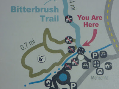
GCNT map
Map with 0.7-mile-long Galena Creek Nature Trail (GCNT)


Getting to Bitterbrush Trail and the adjoining Nature Loop

Get to the South Entrance of the Galena Creek Recreation Area. Find the entrance about three quarters of a mile south (uphill on NV-431) from the North Entrance. The South Entrance is near the junction of Douglas Fir Drive with Mt. Rose Highway  (NV-431). For details and facilities, consult the zoomed-in map above or the Galena Creek Recreation Area map. To pick up a Galena Creek Nature Trail brochure, you want to first stop at the Galena Creek Visitor Center near the North Entrance. Galena Creek Park phone number provided on brochure: (775) 849-2511.

Thursday, April 20, 2017

Kings Canyon Falls: Upper Waterfall Loop

Upper Waterfall Loop trail
Upper Waterfall in North Kings Canyon

The Kings Canyon Waterfalls are a series of falls cascading down North Kings Canyon west of  Carson City, Nevada. The most scenic sites: the lower waterfall accessible via the 0.3-mile-long, hikers-only Waterfall Trail off Kings Canyon Road and the upper waterfall (shown above), which is the main attraction of the 4.4-mile-long Upper Waterfall Loop—a trail open to hiking, mountain biking and horseback riding.

From the trailhead at the end of paved Kings Canyon Road go uphill on the dirt road. Enjoy the view of the land of the former Borda Ranch to your left. Manage those rough wash-outs along the dirt-and-gravel path caused by all the water rushing down the road and across it during rain storms of the wet 2016/2017 winter season. After climbing for a little less than one and a half mile, you will arrive at the south end of the Ash To Kings Trail. For the next 1.8 miles, this single-track trail coincidences with the Upper Waterfall Loop. Leave the dirt road behind and travel the less demandingly ascending single track.  

A notice at the trail junction indicates that this is black bear and mountain lion habitat. A small herd of deer was crossing the trail further up when I came to a forested area. A mountain lion may have watched the deer. Most sections of the trail traverses sagebrush slopes featuring widely scattered pine trees, open enough to view spreading Carson City, the Virginia Range and the blue surface of Washoe Lake, which we missed last year.
 
Kings Canyon Road snaking eastward into downtown Carson City
View of Kings Canyon Road snaking eastward into downtown Carson City
Mingling with sagebrush and bitterbrush scrub is tobacco brush, also know as snowbrush.

Curled snowbrush leaves
Curled leaves of tobacco brush (snowbrush)
On the April day I hiked the loop the snowbrush evergreens were still weeks away from showing their fragrant white-flower inflorescences that often give the appearance of snow blankets. Instead, real snow fields were still shining on the ridges and upper slopes of the Carson Range. And patches of snow covered the forest trail near the upper waterfall. However, a few manzanitas, associating with the snowbrushes, were flowering: their clusters of hanging, rose-pink urns were moving back and forth in the cold wind.

Upper Waterfall Loop trail
Carson Range slope with switchbacks of the Upper Waterfall Loop trail
Above the upper waterfall, a wooden bridge crosses North Kings Canyon Creek. Soon, the trail reaches the junction, from where Ash Canyon is accessible via a 5.4-mile-long section of the Ash To Kings Trail, while the Upper Waterfall Loop starts descending on a steep dirt road with loose gravel. After 0.8 downhill miles, the trail meets the North Kings Loop. It takes another half mile to complete the loop hike. 

Accessing the Upper Waterfall Loop
Get to the waterfall trailhead at the end of the paved section of Kings Canyon Road, as described at the bottom of my previous “Kings Canyon Falls: Waterfall Trail and North Kings Loop” post.
The trail map below gives a nice overview of the waterfall trails and the locations of the lower and upper fall.

Kings Canyon Falls trail map
Map with trails to the waterfalls of North Kings Canyon Creek

Wednesday, April 19, 2017

Kings Canyon Falls: Waterfall Trail and North Kings Loop

Lower Kings Canyon Waterfall
The Kings Canyon Falls trail system west of Carson City consists of loop trails and connector trails. The 0.3-mile-long Waterfall Trail connects the waterfall trailhead with a scenic fall of North Kings Canyon Creek. To see other falls and creek-sides, hike the 1.8-mile-long North Kings Loop or the 4.4-mile-long Upper Waterfall Loop. The latter loop trail has a junctions with the Ash-to-Kings-Trail.

The Kings Canyon area has seen a couple of devastating wildfires in the past. One happened on July 5, 1976. The Fallen Firefighter Memorial at the trailhead commemorates three firefighters that lost their lives during this fire, which was started by a careless camper who failed to fully extinguish his camp fire. The firefighters belonged to a crew of five. They died when their helicopter crashed approximately two miles west of the memorial site.

Across the memorial board you will find the Carson City Parks, Recreation and Open Space board with a map showing North Kings Canyon Creek and the surrounding trails. It reminds us that “clean drinking water begins here: The waterfall is an important source of drinking water for Carson City.”

The short Waterfall Trail is a single-track, hikers-only trail that switchbacks uphill to the lower Kings Canyon waterfall; the most easily accessible waterfall of the Kings Canyon Falls. On your way to this fall you will have passed the trail junction from where the North Kings Loop winds further uphill and into the canyon above the lower waterfall.

North Kings Loop: trail with view of Carson City and Virginia Range

Most sections of the loop trail lead over slopes with views of Carson City and the Virginia Range. Where the trail crosses the creek, you will encounter shrubs and cattails.

Cattails at North Kings Loop creek crossing

After a quarter mile from the creek crossing, the trail meets the Upper Waterfall Loop and continues 0.5 miles downhill on a dirt road, back to the trailhead.

Getting to the waterfall trailhead
From the Nevada State Capitol Building in downtown Carson City, take West King Street and go west. West King Street continues as Kings Canyon Road. Stay on the latter until it changes from paved to unpaved. Find a parking spot and walk up a few steps to the kiosk and firefighter memorial.  

Sunday, March 5, 2017

West-Levee hiking alongside the Yolo Bypass Wildlife Area between Sacramento and Davis

Flooded Yolo Bypass Wildlife Area (March 2, 2017)
The Yolo Bypass is a flood control channel. The winter 2016/2017 saw many news-making floods in California and the Sacramento Valley got its share. Having recently driven over the Yolo Causeway between Sacramento and Davis, you will have noticed water on its south side—as far as the eye can see. Only a few trees are reaching out of the water for the sky.

Yolo Bypass west levee with inland sea
A great way to get close to this temporary lake is by hiking south on the West Levee. To your right you will see wet agricultural land. To your left the shallow water body continues far south, while the skyline of Sacramento is floating in the east. The snow-covered Sierra Nevada stretches along the horizon.

There are various signs alongside the levee indicating that the water level has recently been much higher. You may think of a straight, level levee walk as a boring outdoor experience. It is not. A levee hike is more than just an escape from urban life. There is plenty of wildlife to be seen. The Yolo Bypass coincidences with the Pacific Flyway. Migratory waterfowl and shorebirds can be observed. The water-surrounded trees and bushes are full of them. Egrets keep changing sides between the inland sea and the canals of the farmland. One egret was hanging out in the middle of the levee trail, like he wanted to say this is my world.

River otter torpedoing through Yolo Bypass mudwater
Obviously, river otters enjoy the shallow flood-ocean. I saw two otters playing on a tiny grass island. And a curious one visited me at the bottom of the levee; diving, then popping up again and looking at me. Its swimming resembled a circus performance, including torpedo-like forward moves, cutting through the surface of the water with breathing sounds, suddenly stirring the muddy water in swirls, disappearing underwater, then starting all over again. Not asking for rewards, but happy to be in a restored habitat.

After hiking for about an hour, the levee bends west and one arrives at a lonely, flood-protected house on the right side of the levee curve. Two palm trees are marking the place. A surprise discovery: a stone-carved sailing ship is ornamenting the lower section of the levee-side house wall.

Ornamental sailing-ship relief at the levee-curve house

Getting to the West-Levee access point
The West-Levee access point is located south of I-80, at the west end of the Yolo Causeway about halfway between Sacramento and Davis. 
Coming from Sacramento, take the I-80 exit “County Road 32A East Chiles Road.” Turn right at the stop sign and head south under the freeway. The underpass may be closed due to flooding (as it was for several days in February/March 2017). Find parking near (but not in front of) the levee gate.
Coming from Davis, take the I-80 exit “East Chiles Road” (next to the Fruit Stand) and turn left to get to the short, right-side levee incline and the levee gate. 

References and resources
[1] Mamma Quail:  No More Bypassing the Bypass: Hiking at the Yolo Bypass Wildlife Area [mammaquail.blogspot.com/2014/04/no-more-bypassing-hiking-at-yolo-bypass.html].
[2] Yolo Basin Foundation: About the Yolo Bypass Wildlife Area [yolobasin.org/yolobypasswildlifearea/].
[3] California Department of Fish and Wildlife: Yolo Bypass Wildlife Area [www.wildlife.ca.gov/Lands/Places-to-Visit/Yolo-Bypass-WA].
[4] Overview map of the Yolo Bypass Wildlife Area: nrm.dfg.ca.gov/FileHandler.ashx?DocumentID=87921&inline.