Sunday, October 2, 2022

Ghost mill exploration: walking between big-mill walls and rubble

Trapezoidal-prism-shaped foundation of the Mangum Mill today (September 2022)

The ghost town of Aurora in Nevada has its ghost mill: the Mangum Mill.  The discovery of gold- and silver-rich ore in the second half of the 19th century triggered the foundation of mining towns north of Mono Lake—including Aurora [1-5]. Founded in 1860, one year after Bodie was established, the Aurora Mine Area (elevation around 7,500 feet) had a very short boom time; if any at all. Nevertheless, the mines were kept alive for some decades (see the Aurora Cemetery board section “Boomtown, Then Dust” [1]):

In the early twentieth century, the Aurora Consolidated Mines Company acquired property north of the old town and erected the big mill known as the Mangum Mill. While the company's activities brought some life back to Aurora, it was not a long-lived proposition, closing operations in 1918.

Today there is only rubble left, due to the fact that many buildings were disassembled and the bricks used to make them sold or stolen. Today, the US Forest Service manages a portion of the site.


Not stolen: concrete-anchored metal

The 500-ton mill is named for W. Lester Mangum, who, with Jesse Knight and three others, established the Aurora Consolidated Mines Company in 1912. Construction of the mill was completed in 1914 [2]. Although the company kept Aurora in its name, Aurora was not considered fit as the mining hometown. In the shadow of the mill, the company town of Mangum was established, because Jesse Knight, a member of the Church of Jesus Christ of Latter-day Saints, was displeased with the “sinful life” happening in Aurora. 

The Nevada Expeditions website describes the short time of the mills operation and its final fate [2]:

For the next few years and into World War I, the Aurora Consolidated Co. worked old mines and tailings, processing over 633,000 tons of ore and producing over $1.8 million. By 1918, a shortage of labor due to the war coupled with rising operation costs led to the mill's closure. It was soon dismantled, and both equipment and buildings were relocated to Goldfield and Mangum quickly became but a memory. Large foundations of the Aurora Consolidated Mill remain, but the site of Mangum has since been covered by modern day mining operations.     


Stay out of troubleavoid the rubble!

Today, you can still walk between the remaining walls and rubble of the Mangum Mill. Its terraced foundation can be seen from the air [5]. It seems relatively safe to use the walk ways between the walls that occur on different terrace levels. All around, fallen rocks, wheels, beams and sharp or rusty metal pieces make for trip hazards. An occasional high-altitude rattlesnake may hang out in a rubble shelter during the hot summer months, although it is said they are seldom found much about 7,000 feet or higher. 

Today's Aurora landscape: Mill walls in front, high walls in the back


References and more to explore

[1] Aurora, Nevada. Ghost City of the Dawn. Humboldt-Toiyabe National Forest Board at the Aurora Cemetery site, Bridgeport Road, Nevada. 

[2] Mangum, Mineral County. Nevada Expeditions, 2013-2022. Website: https://www.nvexpeditions.com/mineral/mangum.php.

[3] Aurora, Nevada. Western Mining History. Website: https://westernmininghistory.com/towns/nevada/aurora/.

[4] Aurora. Atlas Obscura. Website: https://www.atlasobscura.com/places/aurora-nevada.

[5]  Drone footage of the Ghost Town of Mangum, Mineral County, Nevada. YouTube: https://www.youtube.com/watch?v=41EhnRRMRm0.

Inspiring Mangum Mill memories: beams below clouds

Wednesday, September 28, 2022

Carson Range recreation: from Spooner Lake to Marlette Peak, northwestern Nevada

Marlette Lake with Marlette Peak above Rocky Point 

The 6.5+-mile-long route (one way) from Spooner Lake to Marlette Peak (elev. 8780 ft) leads mostly through mixed forest—with the exception of the open-slope grandeur around the west and south side of the conic peak. Instead of starting at Spooner Lake, hikers and mountain bicyclists also like to travel the alternative route to Marlette Peak from Spooner Summit along the Tahoe Rim Trail.

Spencer's Cabin
Here, I am following the route starting at the trailhead in the Spooner Lake Management Area. A short walk from the parking lot west of Spooner Lake's dam takes you to rustic Spencer's Cabin. Following the wide path used by hikers and bicyclists, you soon will arrive at the kiosk with the Marlette Lake Trail sign. The 3.75-mile-long trail to the southern tip of Marlette Lake is a single-track, hiking-only trail; while the wide path—
Marlette Lake Trail sign
North Canyon Road
—also leads to the lake and is open for mountain biking.

About half-way along Marlette Lake Trail, you will pass the Woodcutter's Cabin site. Continue the steady climb until you get to a saddle separating North Canyon from the lake basin, then descend for a half a mile to the trout hatchery at Marlette Lake

Rocky Point with a stretch of Marlette Lake's shoreline

From the hatchery, it takes 0.3 miles along the northeast side of the lake to a road junction, from which you can access Rocky Point, return to Spooner Lake on North Canyon Road, or begin your climb to the Marlette Overlook and to the point where the road intersects with the Tahoe Rim Trail (TRT). 

On the way between Rocky Point and Marlette Overlook

Turn left on the TRT to the Marlette Peak Campground (Marlette PK CG). If you continue northbound on the TRT, halfway around Marlette Peak, you will get to a junction, where a post directs you to the South Marlette PK Loop and back to Marlette PK CG. 
South Marlette Peak Loop Trail

The South Marlette Peak Loop Trail is where you want to rest and celebrate the magnificent view of Marlette Lake, Snow Valley Peak, Lake Tahoe and the Sierra Crest in California.   

Marlette Lake with Lake Tahoe further back


Saturday, June 25, 2022

Lincoln Bypass Trail, Carson City, Nevada

Lincoln Bypass Trail near Carson City
Longview/Kingsview Way post

The Lincoln Bypass Trail connects Carson City with the trail system of the Kings Canyon waterfall area in the Humboldt-Toiyabe National Forest. This 4.4-mile-long hiking, mountain biking and horseback riding trail starts at the intersection of Kings Canyon Road and Longview Way in West Carson City and ends at the south trailhead of the Ash Canyon to Kings Canyon Trail. Today's Kings Canyon Road section between the Kings Canyon Rd/Longview Way trailhead and the Ash-to-Kings trailhead, which you are bypassing by using the accordingly named single-track trail, was part of the original 1913 Lincoln Highway.

Green band alongside the downhill path of water into Kings Canyon Creek 

The Lincoln Bypass Trail—completed in October by Sierra Trail Works & Muscle Powered—is much more than a bypass trail: it's a great addition to the Kings Canyon/Ash Canyon trail system. 

Prickly poppy 
Mariposa lily

The bypass trail is a scenic trail by itself. In late spring, Sierra/Great Basin wildflowers such as prickly poppies and Mariposa lilies are blooming alongside the path. Winding up through a short canyon at the edge of a Carson City neighborhood, the mellow-graded trail traverses a sagebrush plateau with amazing views of forested Carson Range slopes and continues through shrub, including snowbrush and wild rose shrub, before entering open pine forest, crossing Kings Canyon Creek and concluding its path at a stand of cedar trees. See the signpost below with directions for continuing on the Upper Waterfall Loop trail. The trail map at the kiosk on the other side of Kings Canyon Road shows the waterfall loop trail; but not the Lincoln Bypass Trail (as of June 2022).

Stand of cedars where the bypass trail continues to the Upper Waterfall  


Getting there

From the Nevada State Capitol Building in downtown Carson City, take West King Street and go west. West King Street continues as Kings Canyon Road. Find parking where Longview Way and Kingsview Way meet Kings Canyon Road. The trailhead is on the left side west of Kingsview Way. 


References and more to explore

[] Lincoln Bypass /mountain bike trail. Trailforks. URL: https://www.trailforks.com/trails/lincoln-bypass/.

[] Staff Report (Gregg Berggren, Trails Coordinator): Capital to Tahoe/Lincoln Bypass Trail. URL: https://www.carson.org/home/showpublisheddocument/77624/637696192196230000.

[] Lincoln Highway Era (1913-1928). URL: https://4thprater.onlinenevada.org/era/lincoln-highway-era.

[] The Lincoln Highway in Nevada. Nevada Magazine, March-April 2013. URL: https://nevadamagazine.com/issue/march-april-2013/539/.

Mountain bikers on track at a switchback of Lincoln Bypass Trail


Saturday, May 28, 2022

Dead Truck Canyon Trail, Prison Hill, Nevada

Hello again!

Dead Truck Canyon Trail connects the Silver Saddle Ranch east of Carson City with the upper trails in the Prison Hill Recreation Area. The 1.7-mile-long trail ascends from the Carson River valley through an east-west canyon on the east side of the highest point at 5,724 ft (1,745 m) in the Prison Hill complex.


Dead Truck Canyon rock

The single-track Dead Truck Canyon Trail is a hiking, mountain biking and horseback riding trail with 800 ft (244 m) of elevation gain. The sandy trail winds through sagebrush and gets rockier while you climb uphill with interesting rock formations on both sides of the canyon trail. About half-way you will find the eponymous truck—or what is left of it. How did it get there? Obviously, this is an exciting place to take a break and have some fun. Even your dog will appreciate the shade under the roof of this stranded car. 

A coyote curiously watching who is coming up the trail

Dead Truck Canyon Trail coincidences with part of the Escape From Prison Hill Trail, along which a half marathon is now organized each year. This race of 13.1 miles includes and continues beyond the narrow canyon, rocky terrain, and steep hills you experience and pass on your way up on Dead Truck.  

Marking the end of the first mile of the half marathon


Getting there

From the 5th Street Trailhead at the northern tip of the Prison Hill Recreation Area, which is located next to the intersection of E 5th St. and Carson River Rd. in the eastern part of Carson City, continue on in south-east direction towards the Silver Saddle Ranch at 2648 Carson River Rd. Turn right at the ranch entrance sign. After about a quarter mile, where the one-way road bends right (east), there are a few parking lots for at-the-spot access of the Dead Truck Canyon Trail and the Valley View Loop. Alternatively, you may want to consider starting out from the main parking area next to the ranch buildings—less than a quarter mile away.

Dead Truck Canyon trail network 

PDF Map

Prison Hill Recreation Area and Silver Saddle Ranch:

https://www.beneficialdesigns.com/wp-content/uploads/2019/09/Prison-Hill_reduced_2019-04-24.pdf.


More to explore

Kyler Klix. Prison Hill: Several trails with varying difficulty. Nevada Appeal, April 10, 2021. URL: https://www.nevadaappeal.com/news/2021/apr/10/prison-hill-several-trails-varying-difficulty/.

Escape From Prison Hill Half Marathon, 10K & 5K. Halfmarathons.netURL: https://www.halfmarathons.net/nevada-escape-from-prison-hill-half-marathon-10k/.


Sunday, November 21, 2021

A mid-November hike: Western Greenway Trail leading through wooded land and public-access parcels of Waltham, Lexington and Belmont in Massachusetts

Western Greenway Trail in the Chester Brook Corridor

The Western Greenway Trail is a recreational, mostly single-track trail snaking through a green necklace with multiple access points at neighborhoods in Waltham, Lexington and Belmont, Middlesex County—northwest from downtown Boston. The roughly eight-mile-long trail offers mountain bikers, runners and hikers a variety of paths through forests and across bogland. 

The Greenway Trail is well marked. Expect boardwalks, bridges, roots and rocks along the way. Detailed maps, which show sections of the trail in reference to joining and intersecting paths, trailside points of interests and nearby neighborhoods, are available online. Here are the map links in the Waltham-to-Belmont sequence: Storer Conservation Trails, Chester Brook Corridor, Middlesex County Hospital Lands, Beaver Brook North Reservation, Rock Meadow, and Lone Tree Hill Belmont Conservation Land

 I went on a hike from Waltham to Belmont along the Greenway Trail on November 20, 2021, by starting at the Waltham commuter rail station and calling the hike done at the Waverley station. Both stations are on the MBTA Fitchburg Line and are served every two hours on week-end days with a train arriving from and going to Boston's North Station

From the Waltham station, I walked north on Elm St, Church St and Lyman St to get to the Meeting House Walkway next to Beaver Street. Close to Forest Street, the Western Greenway Trail ascends on the left side off the Meeting House Walkway. After about ten minutes I arrived at the landmark Stonehurst country house, a “must-see” historic landmark of the Robert Treat Paine Estate. According to an onsite panel, “Stonehurst is an icon of American design created by architect Henry Hobson Richardson and landscape architect Frederick Law Olmsted.” The grandeur of this place—including the country house, an open, smoothly undulating hillside and a glacier rock with amazing views—attracts many visitors. 

Historic Stonehurst country house, seen from Glacier Rock

Continuing north on the Greenway Trail, I came to another panel listing native trees found at the estate: red maple, sugar maple, red oak, white oak, eastern white pine and Canadian hemlock. From this point onward, most trail users were mountain bikers. What follows are selected snapshots along and off the Greenway Trail. 

A part of Lexington's West Meadow, a large quaking bog, seen from the boardwalk 

Greenway trail bridge over Beaver Creek connecting Waltham (left side) with the Rock Meadow in Belmont

Rock Meadow near Beaver Brook

Pine Allee

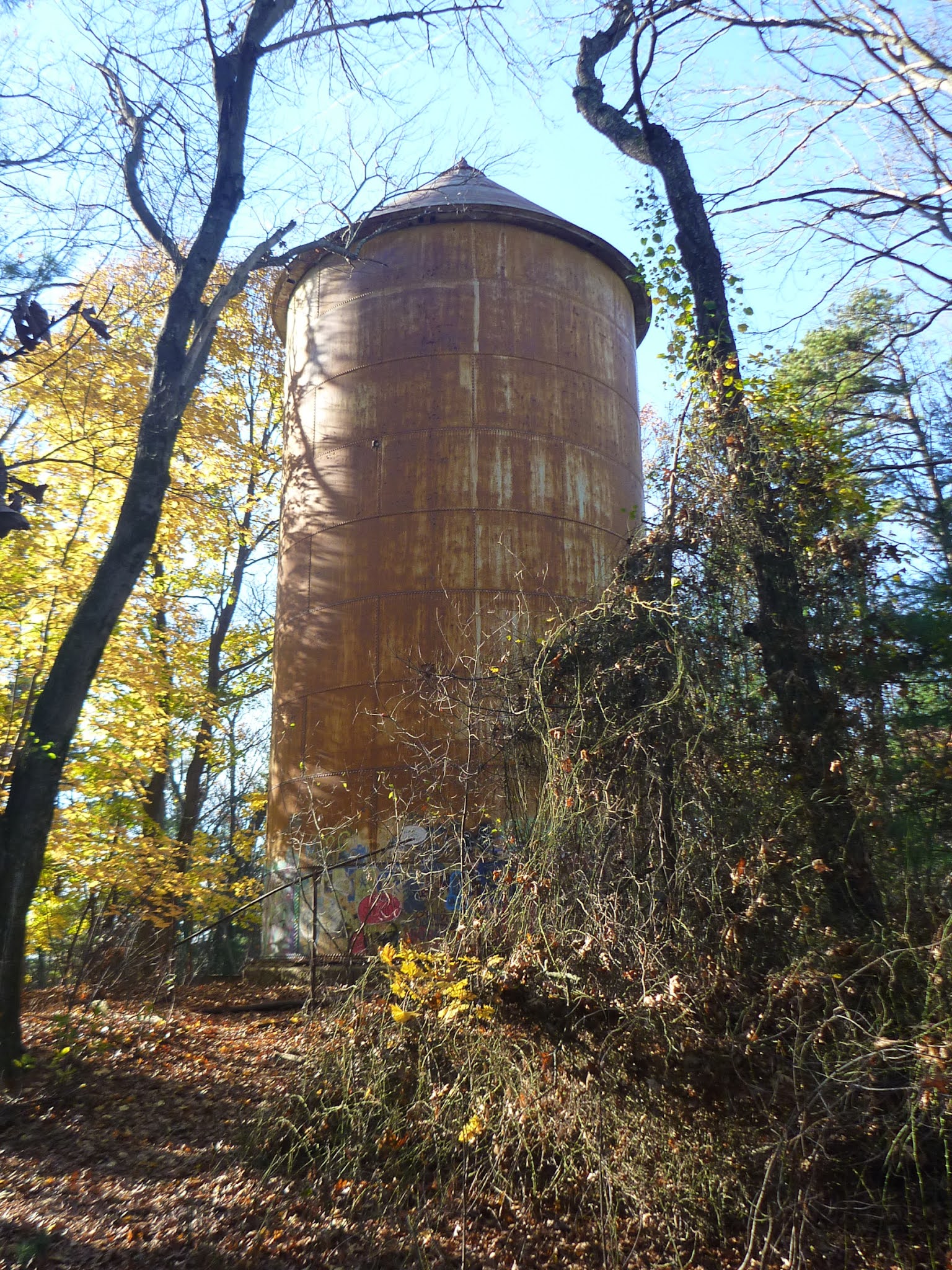
Water tower between Pine Allee and McLean Woods


Maps of the Waltham-Lexington-Belmont green necklace

In the following, I have listed URLs for the trail section maps and included some keywords of what you can find in each map, i.e. what you may want to see while traveling the Western Greenway Trail through the green necklace and exploring it sideways.


Storer Conservation Land TrailsMap 

Western Greenway trailhead at Meeting House Walkway parallel to Beaver Street, Stonehurst (Paine Estate), Chester Brook Woods. URL: https://walthamlandtrust.org/wp-content/uploads/2017/03/2016-11-12-GOS-Storer-Conservation-Trails-Rotated.pdf.


“Chester Brook Corridor” Map

YMCA Land and Shady's Pond Conservation Area. URL: https://walthamlandtrust.org/wp-content/uploads/2017/03/2016-08-19-GOS-Chesterbrook-Corridor-Rotated.pdf.


 “Middlesex County Hospital Lands” Map

Falzone Park (Waltham) and Water Tower (Lexington). URL: https://walthamlandtrust.org/wp-content/uploads/2017/02/2016-08-19-GOS-Middlesex-County-Hospital.pdf


 “Beaver Brook North Reservation” Map

Long boardwalk across bog (with bog-watching benches) west of the “Avalon at Lexington Hills” complex and Beaver Brook North Reservation. URL: https://walthamlandtrust.org/wp-content/uploads/2017/07/2017-07-29-GOS-Beaver-Brook-North-Reservation.pdf.


 “Rock Meadow” Map

Wetland, Twin Oaks, bee hives. URL: https://www.massaudubon.org/content/download/19735/276592/file/WG_Rock-Meadow-Trail-Map.pdf.


 “Lone Tree Hill” Map

Pitch Pine Woodland, Pine Allee, Red Maple Swamp, Water Tower, Eastern Woods, McLean Woods. Eastside trailhead (ten minutes away from Waverley train station): continue southwest on Pleasant St, turn left on Trapelo Road, which bridges the railroad tracks at the station. URL: https://www.belmont-ma.gov/sites/g/files/vyhlif6831/f/file/file/lone_tree_hill_trail_map.pdf.


References and more to explore

The Western Greenway. Waltham Land Trust. URL: https://walthamlandtrust.org/the-western-greenway/. Further trail maps for the Waltham area are provided for download by the Waltham Land Trusthttps://walthamlandtrust.org/trail-guides/.

Mountain Biking Western Greenway. Singletracks. URL: https://www.singletracks.com/bike-trails/western-greenway/.


Sunday, November 14, 2021

Cascade Trail in the Middlesex Fells Reservation

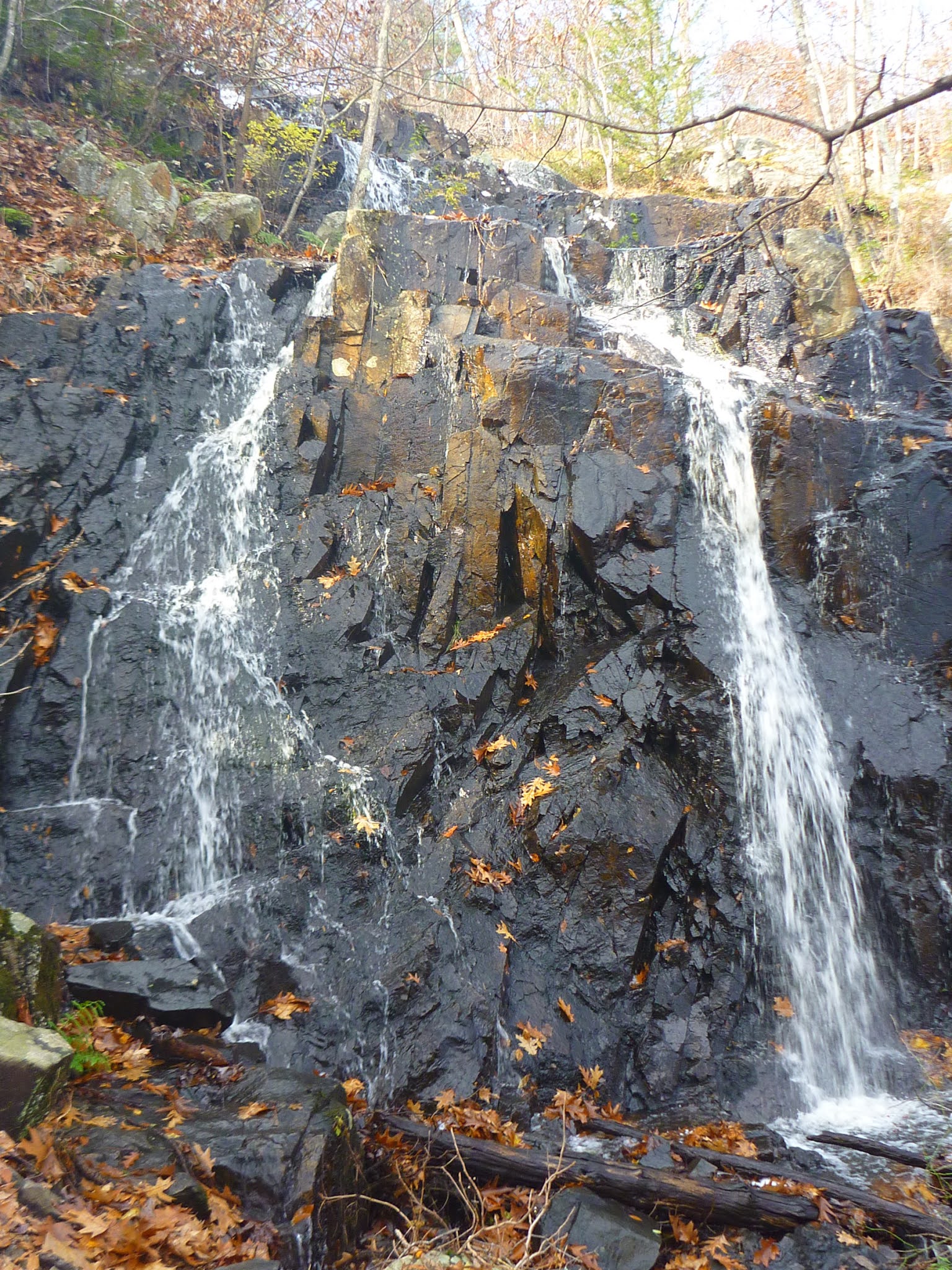
One of the closest natural waterfalls to the city of Boston: Cascade Falls (seen on Nov. 14, 2021)

The Cascade Trail is a short trail to a horsetail-type waterfall in the southeast corner of the Middlesex Fells Reservation north of Boston, Massachusetts. This trail shares its trailhead with the east-side trailhead of the Cross Fells Trail at the end of Goodyear Ave in Melrose, Middlesex County. The Cascade Trail gently winds among hillside oaks to the base of the falls.

The Cascade Trail marker is the upright yellow rectangle, which you will see fixed on trees. The hike from the trailhead to the cascade rocks (0.15 mile one-way) takes no longer than ten minutes. 

The waterfall—called Cascade Falls or simply Cascade—is a combination of horsetails and plunges. The water source is the Shilly Shally Brook [1].


Getting to the trailhead

From Boston, take a train of the Orange Line to Oak Grove, which is the last stop on its northbound route. Walk north on Washington Street. After less than half a mile—at the Melrose Garden Triangle—turn left on Goodyear Ave [2]. This short road ends where the Cross Fells Trail and the Cascade Trail begin. 

See the Friends of the Fells map for the Fells trail network [3]: find the Shilly Shally Brook and the Cascade in the lower left section above the Legend table.


 A horsetail-type waterfall: Cascade Falls with two bottom horsetails on the day I was visiting (Nov. 14, 2021 - after a rainy night)

References and more to explore

[1] The Cascade, Melrose, MassachusettsNew England Waterfalls. URL: https://newenglandwaterfalls.com/ma-thecascade-melrose.html.

[2] Best of Boston. The Cascade at Middlesex Fells Reservation. Boston Magazine. URL: https://www.bostonmagazine.com/best-of-boston-archive/2015/the-cascade-at-middlesex-fells-reservation/.

[3] Middlesex Fells Reservation Map: https://www.friendsofthefells.org/wp-content/uploads/2014/04/Fells_Reservation_Map.pdf.


Saturday, October 30, 2021

Rock & boulder hiking in the Lynn Woods Reservation: from Dungeon Rock to Balanced Boulder

A pond with boulders next to Boulder Path in the Lynn Woods Reservation 
The Lynn Woods Reservation is the second largest municipal park in the greater Boston area. It makes up a fifth of the area (about 2,200 acres) of the City of Lynn north of Boston. The park is roughly divided into equally sized areas north and south of the Walden Pond reservoir.  Both sides are crisscrossed by multiple trails along which you can explore points of historical and geological interest. The handout map contains the following administrative information:

Founded in 1881, Lynn Woods Reservation, is a 2,200-acre municipal forest park located in Lynn, Massachusetts. The City of Lynn's Department of Public Works, Park Commission, and Lynn Water & Sewer Commission share jurisdiction and management of Lynn Woods Reservation. The park encompasses nearly one-fifth of the entire land area of the city and represents a significant natural, watershed, and public recreational resource in eastern Massachusetts.

Beyond dog walking and hiking, the recreational activities in the park include mountain biking and bouldering. Early this fall, I hiked from the Pennybrook Road Entrance to the Balanced Boulder on mostly single-track trails including Jackson Path, Boulder Path, Richardson Pathway, Comel Path and Overlook Trail. I found this to be an apt sequence of trails alongside which one can get an impressive overview of the park's rocks, boulders and crags.

Starting at the Pennybrook Road Entrance, it just takes a short walk on Jackson Path to get to Dungeon Rock and nearby Union Rock.

Upstairs to the Dungeon Rock formation
Continuing northwest on Dungeon Road and soon turning right on Cooke Road leads to the south-end Boulder Path junction. The shallow pond shown in the top picture is on the left side of Boulder Path.

Boulder Path
After about half a mile this path meets Cooke Road again. A very short climb took me to the Stone Tower on top of Burrill Hill. Here, the Richardson Pathway intersects with Cooke Road. The Walden Pond reservoir is located north of Burrill Hill. To get around the southeast tip of the reservoir, I hiked Richardson Pathway downhill (east of the Stone Tower), turned left at its junction with Comel Path and shortly, at the end of this path, right on Great Woods Road

Boulder assembly next to Richardson Pathway
At the reservoir tip, I turned left on Ox Pasture Road, which I followed for half a mile along the lake to the point where the Overlook Trail splits off to the left. This trail continues over rocky terrain, still relatively close to Walden Pond, but which often was not visible through the forest or intersecting rock formations. Around Overlook Crag I tried different rock plateaus for varying, but never complete views of the extending body of water.  

Overlook Crag: view of parts of Walden Pond
Northwest of Overlook Crag, the trail winds slightly away from the reservoir, continuing to the Great Frog Boulder and the Balanced Boulder.
Great Frog Boulder


Balanced Boulder

References and more to explore

[1] Map: Lynn Woods Reservation. URL: http://www.cityoflynnoecd.net/documents/resource/maps/Lynn_Woods_2009-01-20.pdf. Note: this map is also provided at certain Lynn Woods trailheads such as the Pennybrook Road Entrance.

[2] Welcome to the Lynn Woods Reservation. City of Lynn. URL: http://www.lynnma.gov/departments/lynnwoods.shtml

[3] Kiley Jacques. A Visit to Lynn Woods Reservation. Northshore Magazine. May 2, 2016. URL: https://www.nshoremag.com/faces-places/a-visit-to-lynn-woods-reservation/.

[4] Peyton Moreno. The Role of Friends of Lynn Woods. Friends of Lynn Woods. November 2, 2020.  URL: http://www.lynnwoods.org/.


Unnamed boulder next to Overlook Trail