 |
| Lincoln Bypass Trail near Carson City |
 |
| Longview/Kingsview Way post |
The Lincoln Bypass Trail connects Carson City with the trail system of the Kings Canyon waterfall area in the Humboldt-Toiyabe National Forest. This 4.4-mile-long hiking, mountain biking and horseback riding trail starts at the intersection of Kings Canyon Road and Longview Way in West Carson City and ends at the south trailhead of the Ash Canyon to Kings Canyon Trail. Today's Kings Canyon Road section between the Kings Canyon Rd/Longview Way trailhead and the Ash-to-Kings trailhead, which you are bypassing by using the accordingly named single-track trail, was part of the original 1913 Lincoln Highway.
 |
| Green band alongside the downhill path of water into Kings Canyon Creek |
The Lincoln Bypass Trail—completed in October by Sierra Trail Works & Muscle Powered—is much more than a bypass trail: it's a great addition to the Kings Canyon/Ash Canyon trail system.
 |
| Prickly poppy |
 |
| Mariposa lily |
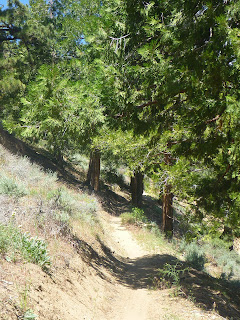
The bypass trail is a scenic trail by itself. In late spring, Sierra/Great Basin wildflowers such as prickly poppies and Mariposa lilies are blooming alongside the path. Winding up through a short canyon at the edge of a Carson City neighborhood, the mellow-graded trail traverses a sagebrush plateau with amazing views of forested Carson Range slopes and continues through shrub, including snowbrush and wild rose shrub, before entering open pine forest, crossing Kings Canyon Creek and concluding its path at a stand of cedar trees. See the signpost below with directions for continuing on the Upper Waterfall Loop trail. The trail map at the kiosk on the other side of Kings Canyon Road shows the waterfall loop trail; but not the Lincoln Bypass Trail (as of June 2022).
 |
| Stand of cedars where the bypass trail continues to the Upper Waterfall |
Getting there
From the Nevada State Capitol Building in downtown Carson City, take West King Street and go west. West King Street continues as Kings Canyon Road. Find parking where Longview Way and Kingsview Way meet Kings Canyon Road. The trailhead is on the left side west of Kingsview Way.
References and more to explore
[] Lincoln Bypass /mountain bike trail. Trailforks. URL: https://www.trailforks.com/trails/lincoln-bypass/.
[] Staff Report (Gregg Berggren, Trails Coordinator): Capital to Tahoe/Lincoln Bypass Trail. URL: https://www.carson.org/home/showpublisheddocument/77624/637696192196230000.
[] Lincoln Highway Era (1913-1928). URL: https://4thprater.onlinenevada.org/era/lincoln-highway-era.
[] The Lincoln Highway in Nevada. Nevada Magazine, March-April 2013. URL: https://nevadamagazine.com/issue/march-april-2013/539/.
 |
| Mountain bikers on track at a switchback of Lincoln Bypass Trail |


No comments:
Post a Comment