Saturday, February 25, 2017

Out of the canyon: Upper Evans Trail

Upper Evans Trail
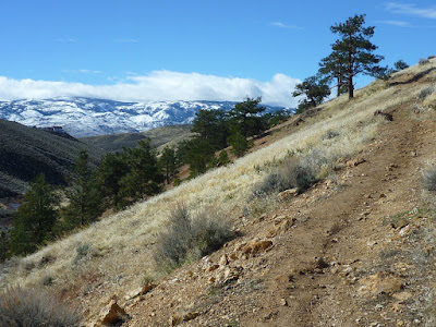
Upper Evans Trail with views of Evans Canyon and the snow-covered Carson Range in the background

At the lower Upper Evans Trailhead
Upper Evans Trail is your way out of Evans Canyon north of Reno, where Evans Canyon Trail and Miners Trail close the canyon trail loop—at Trail Marker 6. This junction is located about one mile north of the Basque Sheepherder Monument. The lower Upper Evans Trailhead can also be accessed from the Vista Rafael Parkway.

A couple of switchbacks lead uphill between pine trees toward a hilltop of altered volcanic rock. Enjoy views of Evans Canyon, the Red Hills and the north end of the Carson Range. Alongside the brown-red outcrops, the single-track trail eventually broadens and continues in southwest direction.

Altered volcanic rock next to Upper Evans Trail
Soon, you will arrive at Trail Marker 17, a Y-junction with an option to take Reno Vista Trail and then “N” Trail to descend back into Evans Canyon. Otherwise, continue on Upper Evans Trail by taking the right fork. This single-track trail leads to UNR DH Trail, Keystone Canyon Trail and to the Hoge Road Trailhead.

I am not sure if there is a designated upper Upper Evans Trailhead. Each non-loop trail should have a second trailhead (or trail-end). But Upper Evans Trail loses itself by intersecting and merging with various other trails and dirt roads. Consider Upper Evans Trail as a warm-up trail, if your plan is to manage further distances and longer loops within the network of  Peavine Trails—the growing trail network west of Keystone Canyon.

With regard to mountain biking, Trailfork characterizes Upper Evans Trail as “fun semi-technical singletrack.” Its difficulty rating is “Blue” with a “Black Diamond” climb difficulty. The January and February 2017 snow and rain storms added some extra challenges such as trail cracking caused by runoff water.

Monday, February 20, 2017

Evans Canyon's Miners Trail

Miners Trail follows the west side of Evans Creek, roughly paralleling Evans Canyon Trail. Both trails provide access to other running, hiking and mountain-biking trails of the Peavine landscape between north Reno and Stead in northern Nevada.

Miners Trail between Reno Mizpah Trail junction and “Miners Junction”
At Reno Mizpah Trail junction
Miners Trail and Evans Canyon Trail share the same trailhead at their south end near the Basque Sheepherder Monument next to the Reno Sports Complex and the disc golf field. From the trail intersection at the north tip of the grove through which the Nature Trail loops, Evans Canyon Trail follows the bank of Evans Creek, while Miners Trail (and “N” Trail) ascend westbound—indicated by Trail Marker 10. Climbing a short section, Miners Trails continues as a level, multi-track trail. Pass by its junctions with Snake Run and Reno Mizpah Trail, which both lead downhill to Evans Canyon Trail. Shortly, Miners Trail switches back towards the canyon as a single-track trail and follows a line just above Evans Creek.
Evans Creek with Miners Junction”
Soon, you will arrive at the H-junction at Trail Marker 7. At this so-called “Miners Junction,” Miners Trail and Evans Canyon Trail meet, connected by a path across Evans Creek, which is dry most times of the year. But during snow melting or after plenty of rain the north-south flowing Evans Creek can result in getting your shoes wet while crossing. Return on Evans Canyon Trail, if you simply want to do the Evans Canyon Loop, as shown in the map of my Evans Canyon post. Otherwise, continue north along Miners Trail until you get to an open hill-side stand of pine trees. Here, you will find the older Miners Trail post surrounded by pine-tree twigs, as shown in the top picture.

Hill-side pine trees near the north end of Miners Trail
Ready for a larger loop: Find Trail Marker 6 directing you to Upper Evans Trail leading uphill to Reno Vista Trail and UNR DH Trail. They all traverse sage-covered landscape with open views, making it easy to spot a trail that takes you downhill and back to your starting point.   

Friday, February 17, 2017

Evans Creek and Evans Canyon Trail

Evans Canyon north of the Basque Sheepherder Monument at Rancho San Rafael, Reno, Nevada

Rancho San Rafael Regional Park extends up into the Peavine area, featuring a multi-use trail network north of Reno, Nevada. The north-south stretching Evans Canyon separates the neighborhoods west of North Virginia Street from the Peavine open-space hills, including the one with UNR's letter “N” on its southeast-facing slope.

Evans Canyon Trail is a popular running, hiking and mountain biking trail. Its south end can be accessed from the free parking area at the Reno Sports Complex—northwest of the N. McCarran Blvd./N. Virginia St. intersection. Follow the short trail that traverses the disc golf field and leads to the Basque Sheepherder Monument. Continue downhill to the creek and grove with a Nature Trail. There, a small panel introduces Evans Creek:

Evans Creek probably began to form about three million years ago by erosion of a small stream as Peavine Mountain uplifted along with the Sierra Nevada.

Most of the erosion in the canyon probably occurred during the Ice Ages, when precipitation was greater than at present. Periodic floods caused most of the erosion in the canyon and deposited the gravels in the streambed. 

Although Evens Creek is now covered with heavy vegetation, a future flood could wash away the streambed and the plants. New vegetation would repopulate the streambed, continuing a cycle millions of years old.


The trail downhill from the Basque Sheepherder Monument can get flooded.


Erosion is going on. The winter of  2016/2017 brought more precipitation than recent winters. The temporary streambed seen in the picture above functions as a dry trail most times of the year.

Evans Canyon Trail follows Evens Creek on its left bank for about half a mile. Then, the trail crosses the creek and continues to the H-junction—a cross-creek connection with the Miners Trail. This would be your point of creek crossing, if your plan is to do the Evans Creek Miners Loop bringing you back to the grove. Otherwise, you want to continue on the right side of the creek. Evans Canyon Trail ends where concrete stairs lead up to the Vista Rafael Parkway. But you do not need to return the way you came. Take the U-turn trail below the parkway to get to the Miners Trail and the Upper Evans Trail. The Miner's Trail takes you back to the Evans Creek Miners Loop—the Evans Canyon Loop shown in the map below. It is the nature of a trail network that you can enjoy multiple loop options.


The “You Are Here” point in the map is the trail intersection just north of the grove with the Nature Trail. The trail access information on the board posted at the intersection gives the following trail lengths:
  • Nature Trail: 1.1 mi
  • Evans Creek Trail: 0.7 mi
  • Evans Canyon Loop: 1.5 mi
You will find the names “Evans Creek” and “Evans Canyon”  being variously mixed into “Loop” and “Trail” phrases, depending on trail markers, maps and web sites you read. If in doubt which way to take, orientate yourself by the creek and you won't get trapped in the canyon.

Keywords: Reno, Washoe County, northern Nevada, recreation, outdoors, trail network.

Nearby trails and points of interest:


Friday, December 23, 2016

A Christmas market walking tour

 
Christmas market (Weihnachtsmarkt) in downtown Bremen, Germany

Christmas markets are popular throughout Germany and other European countries. Visiting one can be like stepping into a fairy tale setting and leaving the real world behind. But Christmas markets exist in this world and a horrifying, deadly attack on a Berlin market on Monday, December 19, of this year interrupted the joyful pre-Christmas tradition of socializing with a mug of mulled wine or shopping for holiday-inspired, handcrafted goods. With the slogan “Jetzt erst recht!” (“Now more than ever!”), people keep returning to the joy- and colorful world of Christmas markets.

Warm welcome to the Christmas market in Bremen
For those who have never visited a Christmas market in Germany, here is a random walk through the downtown market in the City of Bremen in northern Germany. This tour is not meant to be a historical trip around Bremen's St. Petri Dom (St. Peter's Cathedral), the Bremer Rathaus (Bremen's Town Hall) and the Liebfrauenkirche (Church of Our Lady), where the market spreads out. The tour focuses on selected items you will find and may enjoy on a typical “Weihnachtsmarkt” (Christmas market).
Christmas market hut

Christmas markets are not religious events. They just happen to take place before Christmas. Since this is the time of cold weather, snow, ice and only short periods of day light, Christmas market themes derive from seasonal traditions and desires including the wonder of light, sparkling illumination, warmth, sweets, hot drinks, candles, incense, toys, gifts and handcrafted art. People bring their kids, reunite families and will meet with friends or strangers—often both. In the evening, markets can get crowded when visitors are drawn in or snuggling up under the roofs of market huts, which offer local food specialties and hot non-alcoholic or alcoholic drinks.

100% beeswax
100% Beeswax
Classic favorites are candles; in particular, those made from beeswax. The old custom of lightening a Christmas tree with “Bienenwachskerzen” (beeswax candles) can still be found in Germany. Beeswax candles were “mandatory” with my folks—not only for the tree, but also in stand-alone holders to light up the room without electricity and, at the same time, aromatize the air with church-like incense smell.

Mulled-wine bar
Mulled wine mug
To warm up physically, a mug of  “Glühwein” (mulled wine) definitely helps. Feuerzangenbowle is doing the same or more. However, many consider it too sweet. Especially, if you already got sugared up by “Klaben” (Christmas bread with dried fruits), “Kluten” (black-and-white sugar-chocolate dominoes), candied almonds or whatever else you consumed alongside the cake & candy rows. There are also sweet goods that you can eat, but, instead, may want to hang around your neck as a souvenir or save as a greeting to someone else: gingerbread hearts saying “Frohe Weihnachten” (Merry Christmas)—the sweetest way to promote the message of love & peace.

Christmas market huts next to Bremen's Liebfrauenkirche (Church of Our Lady)

Saturday, November 19, 2016

Hiking between walls of moisture-dripping ferns and mosses: Fern Canyon

Fern Canyon, Humboldt County, California
Slippery, foot-bridge-enhanced trail through Fern Canyon, Humboldt County, California
When visiting the coastal redwood forests of northern California, you are getting used to tilt your head far back to scan the giant trees from root to crown. You want to tilt your head for something else? What about an excursion to spectacular Fern Canyon within Prairie Creek Redwoods State Park? This is a deep gorge, where you will experience a unique botanical adventure by tilting your head (and camera) for California native ferns and mosses clinging to steep cliffs. And if your neck gets stiff, there are plenty of ferns to approach that hang from the lower walls alongside the creek bed.

From the trailhead at the end of Coast Bluff Beach Road, you will arrive at the opening of the stream canyon after a short northbound hike between the beach and bluffs. Level Fern Canyon Trail follows Home Creek, which carved out the canyon through sedimentary soil. River sandals or waterproof boots are the footwear of choice. The creek trail is generally passable; but after a rain storm, especially in winter, a flood may rush through. Foot bridges are installed over the creek during summer months. Year-round, water is dripping down the rock faces, creating a fern paradise, which is the home of dippers and amphibians, including the Pacific giant salamander and the northern red-legged frog.


Fern with radiating fronds at canyon cliff
  
The natural history of Fern Canyon is briefly summarized on an educational panel near the trailhead:

Millions of years ago, a retreating sea left these coastal bluffs behind. Waters draining to the ocean sculpted the rocky formations into sheer canyon walls. Some of the exquisite ferns now clinging to the steep, shadowy cliffs are ancient species whose ancestry can be traced back 325 million years.

The canyon is now shrouded with lush five-fingered ferns, dark green sword ferns, and delicate lady ferns. Scouring winter floods periodically rush through the canyon, sweeping debris from its floor. Spruce and red alder saplings often survive for a few years on small terrace ledges, but they rarely reach maturity before falling off or being swept away.

Seeping waters supply year-round dampness for the dense foliage and provide habitat for a diverse mix of moisture-loving creatures such as salamanders, frogs, and dippers. Several perennial waterfalls cascade from the canyon rim, adding to the cool, moist canyon microclimate.

Fern Canyon, Humboldt County, California
Visitors entering Fern Canyon at its opening near the coast

The Fern Canyon Loop Trail offers round-trip hiking—including a creek and a rim paths. After flooding or a landslide event, however, visitors will find it advisable to return via the route they walked into the narrowing canyon.


Getting to the coast-side trailhead for Fern Canyon
The coast-side trailhead is accessible via unpaved roads. It is located at the midsection of Gold Bluffs Beach. Take Davison Road, which connects Hwy 101 north of Orick with the beach. Find the Entrance Kiosk at the ocean side after driving about 3.5 miles northwest-bound along Davison Road. The kiosk is about half-way between the Davison Road/Hwy 101 junction and your destination. Once through the entrance, follow Gold Bluff Beach Road north toward its dead-end, which is the trailhead to the Gold Bluffs Coastal Trail and the Fern Canyon Loop Trail. Although a relatively remote location, Fern Canyon (and the road and short coastal trail section leading to it) often gets overcrowded in summer.
Fern Canyon can also be reached from the Prairie Creek Redwoods State Park visitor center via a five-mile-long hike (one way) on James Irvine Trail.

References and more to explore
[1] California's Redwood Coast: Fern Canyon in Prairie Creek Redwoods SP [www.redwoods.info/showrecord.asp?id=476].
[2] Phil Rovai (park ranger): Fern Canyon: The Real “Lost World” at Prairie Creek Redwoods State Park [www.scribd.com/document/34241324/Fern-Canyon-The-Real-Lost-World-at-Prairie-Creek-Redwoods-State-Park].


Ferns with waving fronds clinging to a steep wall of Fern Canyon

Friday, October 28, 2016

Shorebird Loop Trail in Humboldt Bay National Wildlife Refuge

Board walk: beginning of the Shorebird Loop Trail
Beginning of the Shorebird Loop Trail at the visitor center
The 1.75-mile-long Shorebird Loop Trail in the Humboldt Bay National Wildlife Refuge is one of many short trails that can easily be reached for a nature stroll in coastal northern California [1]. It is a level lasso-loop trail: it includes an out-and back section to Long Pond and a loop section (the lasso nose) that surrounds the pond and brings you close to Hookton Slough and Teal Island in the South Humboldt Bay. November through April are the best months to watch the impressive variety of waterbirds, including migratory shorebirds. The best day hours for wildlife watching are when dawn or dusk coincidences with the one to two hour window before or after high tide [2]. 

The visitor center and trailhead is at YOU ARE HERE

The trail begins as a board walk at the visitor center. I recently walked the trail one afternoon in summer, not the recommended season for bird-watching. Various interpretive panels along the trail are dedicated to the natural history and the human history of the marshlands. For example, one panel features northern harriers, formerly called marsh hawks, which hover low over marshes and sloughs in search of prey. Then there are peregrine falcons who dive down on their prey at speeds of up to 200 mph (322 km/h).


Marsh lotus, an invasive species from Europe
From the loop trail, I saw strips of yellow pillows, which I was informed at the visitor center are mats of marsh lotus (Lotus pedunculatus). This freshwater-marsh flower from Europe is on the list of invasive species [3].

The Humboldt Bay is a stopover for fuel and energy—not only for tourists, but for migratory birds as well. The latter typically fly north to breed during the Arctic summer and return to warmer wintering regions far south from Humboldt Bay.

Eroding bucket of the Jupiter dredge, once used to dig through marshes and mudflats

The marshlands of Humboldt Bay were changed by dredging. The eroded metal bucket next to the trail along the slough south of Teal Island is a left-over from the marshes-to-pastures days:

This piece of metal is a bucket from the Jupiter dredge [built in 1926 by the Stockton Iron Works in California's Central Valley]. From the 1930s through 1970s, it was used to dig through salt marshes and mudflats to create a system of dikes in the South Bay, transforming wetlands into pasture. This practice reduced the bay's estuary by 40 percent.

Since 1971, when the Humboldt Bay National Wildlife Refuge Complex was established, the agricultural development trend has been reversed to habitat restoration “to conserve precious habitat for the great diversity of birds, mammals, fish, amphibians, invertebrates, and plants that occur in the Humboldt Bay area” [4]. The Shorebird Loop is a relaxing trail, along which to catch a first glimpse of both the restoration efforts and the estuary biodiversity.

Long Pond

Getting to the Shorebird Loop Trailhead
From Highway 101 south of Eureka, take exit 695. Go north on Refuge Entrance Road, parallel to Hwy 101, for about two miles, to where the roads bends west. After another mile, you will see the visitor center to your left. Walk through the open passage onto the board walk and begin your hike on Shorebird Loop Trail.

References and more to explore
[1] Jim Hight: Seven Trails In Your Backyard [http://www.northcoastjournal.com/aug98/8-98.trails.html].
[2] Humboldt Bay Wildlife Refuge [www.redwoods.info/showrecord.asp?id=1728].
[3] U.S. Fish & Wildlife Service/Humboldt Bay: Invasive Species Management [www.fws.gov/refuge/Humboldt_Bay/wildlife_and_habitat/InvasiveSpeciesManagement.html].
[4] See the section Refuge History at https://www.fws.gov/refuge/Humboldt_Bay/about.html.

Wednesday, October 26, 2016

Beach-combing near the North Jetty at the Humboldt Bay Entrance west of Eureka, California

Ocean wave spectacle at the Humboldt Bay Entrance at the south tip of the Samoa Peninsula
A sandy strip of land extends west of Eureka between the Pacific Ocean and Humboldt Bay—the only deep water bay between Coos Bay in Oregon and San Francisco Bay. At the tip (south end) of the north strip—the Samoa Peninsula—is the Samoa Dunes Recreation Area with the North Jetty. Once US military property, this is now a multi-use land run by the Bureau of Land Management. Beach-combing, bird-watching and wave-watching are just a few low-key activities visitors enjoy to do here.

Waves crash over the North Jetty

In case you are walking or picnicking on the beach between the jetty shore line along the bay entrance and the sand dunes, you want to watch the incoming waves for your own safety and pleasure. Usually, they make quite some splash. As with the Crescent City harbor jetty, this jetty line should never be considered completely safe. Often, it is a dangerous place to hang out at. Approach a jetty at low tide and only if no water is spraying over its top. An informative board recommends to “Be swept Away By the Beauty Not By the Sea” and continues:

People have died while walking on the jetties. Beware of sleeper sneaker or rogue waves. They can appear without warning often coming up on the rocks with deadly force. Never turn your back on the ocean!

A wave flowing and foaming over the jetty

Getting there
From Euraka, take Highway 255 across the Samoa Bridge and turn left onto New Navy Base Road. Drive south for about four miles to the Samoa Dunes Recreation Area. At the junction with Bunker Road, from which the latter leads to an OHV staging area with historic ammunition bunkers, stay on the main road until you reach its dead-end. There is parking space in a dry and safe distance from the Humboldt Bay Entrance and the North Jetty.

References and resources
[1] BLM: Samoa Duenes Recreation Area [www.blm.gov/ca/st/en/fo/arcata/samoa.html].
[2] Humboldt Bay recreational map: Humboldt Bay Area Beaches and Dunes [humboldtbay.org/sites/humboldtbay.org/files/humbeach.pdf].
[3] Surfline: Humbold Harbor Entrance HD Cam & Surf Report [www.surfline.com/surf-report/humboldt-harbor-entrance-northern-california_5084/].
[4] Humboldt Bay Entrance, Califirnia Tide Chart [http://tides.mobilegeographics.com/locations/2675.html].