 |
| Volcanic plug exploration: on top of one of the two rock piles on Bishop Peak |
 |
| Summit Trail with view of the summit |
Summit Trail is the path to follow. Don't expect to be alone on the trail or at the summit. California Polytechnic State University is close by: climbing to the top of Bishop Peak seems to be a work-out assignment for most students. The trail winds up a steep, southwest-facing slope. Thanks to the many switchbacks, I didn't experience the upward hike as strenuous (although I overheard people saying it is) and enjoyed the changing vistas of the surrounding rock formations and of Los Osos Valley and the Irish Hills.
To get onto the Summit Trail, I started out from the Highland Drive Trailhead, which is located on the left side near the end of Highland Drive. There, a metal plate—worked into a boulder—has the title Ferrini Ranch Open Space and informs (see picture):
This Bishop's Peak trail leads to a very special place in the community of San Luis Obsipo. For almost a century, the Ferrini Family have been the stewards of this land and in 1995 they gifted this trail and 138 acres of open space to the people of San Luis Obispo.
The one-mile-long Highland Connector Trail connects the Highland Drive with the Summit Trail. The latter, according to the Bishop Peak Natural Reserve trail map, has its starting point at the Patricia Trailhead . The distance to the summit from the Patricia Trailhead is given as 1.9 miles. The distance from the Highland Drive Trailhead to the summit is somewhat shorter.
 |
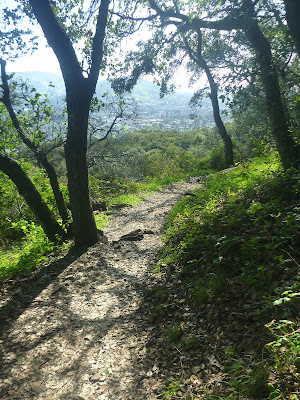
| Shaded forest section of the Summit Trail |
About one half of the hike is across meadows and through shaded oak forest. The other half includes a rockier trail with open views and multiple switchbacks.
 |
| Summit Trail crossing southwest-facing slope |
 |
| View of tumbled-down boulders and Los Osos Valley |
The trail officially ends between two piles of rocks & blocks. If you feel at ease with off-trail explorations, here you may scramble through brushes and grottoes or crawl the final feet to a top position.
 |
| Rock sculptures at Bishop Peak's summit |
Trail maps
There are trail maps alongside the trail:
And there are PDF maps. Here is the link to the Bishop Peak Natural Reserve Trail Map: https://www.slocity.org/home/showdocument?id=16660.
Further reading
Bishop Peak in San Luis Obispo. URL: https://www.hikespeak.com/trails/bishops-peak-san-luis-obispo-hike/ (accessed March 17, 2024).
Exploring the Nine Sisters. March 3, 2013. URL: https://www.slovisitorsguide.com/exploring-the-nine-sisters/ (accessed March 17, 2024).
San Luis Obispo (including a trail map). URL: https://www.sierraclub.org/sites/default/files/sce/santa-lucia-chapter/lucians/BishopPeak.pdf (accessed March 17, 2024).


No comments:
Post a Comment