Tuesday, February 7, 2012
Orange lichen and juniper berries along the Bailey Canyon Creek Trail, Virginia Range, Nevada
The hills and mountain ranges surrounding Truckee Meadows (Reno/Sparks) appear monotonously yellow-gray at this time of the year, especially without any lasting snow cover. Yet, displays of color can be found by hiking into nearby valleys and creeks. A variety of colorful lichen, mosses and pale-blue juniper berries dot the base and slopes of Bailey Canyon. This canyon is located in the Virginia Range southeast of Reno between Steamboat Creek/Pleasant Valley and Virginia City. The limited floor of the canyon, which exhibits a V-shaped cross-section, is a dry wash (weather-related exceptions apply). Currently, a few frozen water puddles are present and provide a hint that occasionally water is flowing through. The narrow trail frequently crisscrosses the stream bed. The orange lichen was seen at the bottom of a rock amid the stream bed. The canyon slopes feature outcroppings of rock composites and pinyon-juniper forest. The juniper brushes show an abundance of berries, reflecting in the sunshine. The juniper berries have the size of blueberries, but taste bitter and are not true berries: they are the seed cones of these coniferous plants. Bailey Canyon, a Nevadan Nature Trail!
Getting there
From South Virginia Street at the Summit Sierra Shopping Mall take Virginia City HWY (Route 341) and, after half a mile, turn right on Toll Road. Follow this road until the pavement ends and find parking (see TopoZone and Bailey_Canyon - Washoe,Nevada maps). Unfortunately, there is no trailhead. Walk south on the dirt road until you arrive at some horse stables. Try to find a path to the right, cross the creek and find yourself on the trail. Although the beginning no-trailhead and no-signpost experience may feel discouraging, the trail now becomes clearly visible and closely follows the canyon bed. No beginning, no end? Based on some local maps, I am assuming that the trail will eventually connect with the Washoe and Virginia Road and Ophir (Jumbo) Grade, taking you either (if turning west) to the eastern shore of Washoe Lake or (if turning east and climbing uphill) to Virginia City and Gold Hill. I still have to give it a try.
Sunday, February 5, 2012
Wilbur D. May Arboretum and Society, Reno, Nevada
The Wilbur D. May Arboretum in Reno is located southwest of the intersection of North McCarran Blvd. and North Virginia Street. The arboretum is a living museum featuring plants in a transitional zone with an arid climate between the Sierra Nevada Mountains and the Great Basin Desert [1]. In addition to local species, the arboretum also showcases plants native to other parts of North America, such as the shown honey locust from Illinois (tolerating drought and poor soils), and shrubs and trees from around the world.
Information about upcoming events, workshops and volunteer opportunities is given by the nonprofit May Arboretum Society, which recently premiered its new website [2,3].
A panel at the arboretum informs that it was initially created in 1982 through funding from the Wilbur May Foundation in memory of Wilbur D. May, a generous philanthropist during his lifetime, who left a legacy to the community with the May Center. Further, the panel describes the extreme locality conditions under which the plants—although being nursed—have to grow and delight visitors:
The Wilbur D. May Arboretum and Botanical Garden is located at an elevation of 4,600 feet on the foothills of Peavine Mountain where the Sierra Nevada Mountain Range meets the Great Basin Desert. Daily temperature ranges can fluctuate 50 degrees [Fahrenheit scale] or more and the average annual precipitation is only seven inches. The majority of the precipitation comes in the form of rain and snow in the cool winter months with hot, dry summers and strong winds throughout a majority of the year. Very few plants can survive in these conditions without human assistance.
Not much precipitation in any form has come so far in this winter's months.
References and links
[1] Washoe County Nevada > Regional Parks and Open Space > May Arboretum: www.co.washoe.nv.us/parks/arboretum/arbor.html.
[2] Lenita Powers: Wilbur D. May Arboretum blooms online [www.rgj.com/apps/pbcs.dll/article?AID=2012302050022].
[3] May Arboretum Society: mayarboretumsociety.org/.
Monday, January 30, 2012
Wild cucumber, or manroot, of North America
Wild cucumbers of the Marah genus (gourd family, Cucurbitaceae) are found on the west coast of North America. The common name “manroot” refers to the large underground tubers that can weigh up to 100 pounds [1]. From these tubers, wild cucumbers sprawl or climb as vines with the help of tendrils that attach the growing plants to shrubs and trees. Most striking (and pricking) are the eye-catching spiny balls, one to two inches in diameter. Sometimes they are dangling from a vine—as in the pictures herein, showing a plant along the Ojai Pratt Trail through chaparral-like habitat south of Santa Barbara in California. The unripe, green fruits typically ripen into non-edible, yellow to brown fruits. The large leaves are palmetedly lobed, with five to seven lobes.
In a recent Bay Nature article entitled “Cool as a Cumber,” Jake Sigg features the two Marah species (M. fabaceus and M. oreganus) that grow in shrublands around and beyond San Francisco Bay [2]. He describes their emergence from summer dormancy with the advent of autumn rains. The best time to admire the spiny fruits is winter. With the beginning of the dry season in spring, the herbage turns yellow-brown and dies back to the tuberous root.
Like with all species in the gourd family, the flowers of the Marah are unisexual [3]: individual flowers are either male or female. But both sexes can be found on the same plant (monoecious plants), on which male flowers fertilize the female ones.
References and more to explore
[1] wiseGEEK: What Are Wild Cucumbers? [http://www.wisegeek.com/what-are-wild-cucumbers.htm].
[2] Jake Sigg: Cool as a Cucumber. Bay Nature January-March 2012, page 10. Also see Sigg's Wild Cucumber (Marah) article at collective roots and his San Francisco Natural Areas contribution.
[3] Gourd Family (Cucurbitaceae) - Biology of Gourds: science.jrank.org/pages/3083/Gourd-Family-Cucurbitaceae-Biology-gourds.html.
Tuesday, January 24, 2012
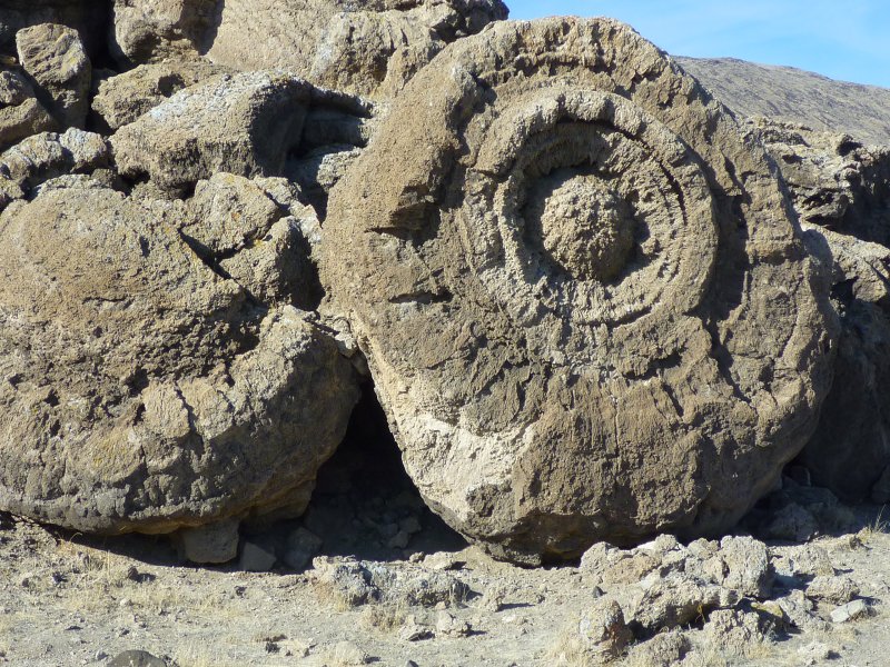
Concentric thinolite layers at Winnemucca Lake
Winnemucca Lake in Nevada is like Pyramid Lake a remnant of the Pleistocene Lake Lahontan. Winnemucca Lake is separated from Pyramid Lake by the Lake Range, but almost meets it at Dago Bay, north of where the Truckee River flows into Pyramid Lake. Winnemucca Lake is mainly a dry lake now: the top picture shows its playa at New Year's Eve 2011. Depending on the day light, it may look like salt or snow. But a hike into the playa confirms that it is sand and soil (which may be covered by snow on some rare, snowy winter days).
The Pyramid-Winnemucca landscape is rich in natural tufa sculptures including Popcorn Rock, Indian Head Rock and the towers and deposits at The Needles. Spectacular tufa formations can be explored at the south end of Winnemucca Lake. There, assemblies of thinolite rolls are scattered along the side of a gentle slope. Getting close to these unusual rocks, one can see crystalline tufa forming concentric layers, as seen in the picture above. How did calcium carbonate deposit and align into these mysterious, round-shaped megaliths?Getting there
From I-80 at Wadsworth near Fernley take Route 447 north. This route enters the Pyramid Lake Indian Reservation along the Truckee River and leads to Nixon. From there, Route 447 continues north to Gerlach and the Black Rock Desert. The site of interest is about five miles north, just past the left-side intersection with the dirt road going to the east shore of Pyramid Lake, the Great Stone Mother & Basket and the scenic Pyramid rock (currently closed). The thinolite tufas are on the right side, off Route 447, which leaves and reenters the Reservation there.
Sunday, January 22, 2012
The steam geyser of Lake Pyramid's Needles area
The tufa structures of the Needles Rocks area at the north end of Lake Pyramid in Nevada make a fascinating landscape for hiking and hanging around. Between the shoreline and the tufa mounds is a steam geyser, spraying hot water over 25 feet high. The hot water is running down into the lake and green plants can be seen thriving and bending in the flow of warm water.While relaxing at the geyser fountain, enjoying its splashing sound and the sun-light reflections in the falling water droplets, one's thought may go back in time and imagine (diving) this place during the days of Lake Lahontan: instead of ejecting into the air, the hot and calcium-rich water would have mixed with the lake water and initiated chemical reactions causing calcium carbonate (CaCO3) precipitation and tufa formation.
Saturday, January 21, 2012
Hiking between tufa pinnacles and mushroom castles
Tufa deposits of various sizes and shapes can be found in California and Nevada, typically along the shores of Pleistocene lakes and their present remnants (often dry lakes or valleys today) such as Honey Lake, Pyramid Lake, Mono Lake, Indian Wells Valley, Panamint Valley, Searles Lake and the Salton Sea [1]. An impressive diversity of tufa mounds and cementations can be explored at the north end of Pyramid Lake in Nevada. This location is often referred to as “the Needles.” The Needles Rocks, like Popcorn Rock and Indian Head Rock, were built in the past during times of higher water levels, when upwelling calcium-laden spring water entered the lake along fault zones and mixed with colder, carbonate-rich lake water [2].
The tufa formations in the Needles area include spread-out mounds composed of interlocking spheres and barrels and tall mounds (towers) reaching elevations 100 m above lake level [3]. Tufa is mainly calcium carbonate, but some tufa deposits contain cells of algae. The variation in composition, density, porosity and crystallinity results in a multitude of forms including encrusting, fiber-forming and branching tufa. Many can be discovered between and around the Needles.
Getting to the Needles
Route 445 along the west side of Lake Pyramid ends at Warrior Point as a paved road and continues on as Indian Land Route No. 2. The dirt road to the Needles has been closed. The “tufa incarnation of the first President of the United States of America,” George Washington Rock, about five miles north of Warrior Point, is a good location to view Wizard Cove and the Needles. Depending on your time, you may start anywhere along the shore and hike north. The tufa mounds can be seen from far away. But remember that you are in desert country: features that look like they are nearby, may still be miles away. Also, you may sink or break in by stepping onto unstable ground, what will further delay your approach.
References and more to explore
[1] Tufa on pages 116-118 in California Geology by D. R. Harden. Second Edition. Pearson Education, Inc., Upper Saddle River, NJ, 2004.
[2] Tufa on page 145 in the guide book Geologic and Natural History Tours in the Reno Area by J. V. Tingley, K. A. Pizarro, C. Ross, B. W. Purkey and L. J. Garside. Nevada Bureau of Mines and Geology Special Publication 19, University of Nevada, Reno, 2005.
[3] Larry Benson: The Tufas of Pyramid Lake, Nevada. USGS, Circular 1267, last updated 2004 [plpt.nsn.us/geology/index.html].
Wednesday, January 18, 2012
Indian Head Rock at Pyramid Lake
Indian Head Rock next to the shoreline of the lower west side of Pyramid Lake is—like Popcorn Rock—an eroding tufa mound. This complex of deposited calcite (calcium carbonate) showcases various forms of tufa such as coralline and crystalline-layered tufa. Differently rounded and coated parts of the ludicrous-looking mound are interlocking with each other. The picture below shows a thinolite arch at Indian Head's base with crystalline tufa forming concentric layers of fibrous and branched calcite structures.
Finding Indian Head Rock
Indian Head Rock is located along Route 446 between its intersection with Route 447 at Nixon and its intersection with Route 445 a few miles further north. From the rock complex, it is only a short walk to Indian Head Beach.
Finding Indian Head Rock
Indian Head Rock is located along Route 446 between its intersection with Route 447 at Nixon and its intersection with Route 445 a few miles further north. From the rock complex, it is only a short walk to Indian Head Beach.
Subscribe to:
Posts (Atom)