Saturday, September 30, 2023

Berlin Townsite Trail, Nevada

The largest structure in the townsite: the Berlin Mill with the ore chute pointing uphill into the direction of the mine entrance
Berlin is a ghost town at the western edge of the Shoshone Mountains in central Nevada. This area is known as the Berlin Historic District. Historic buildings in the Berlin State Park are maintained in a state of  “arrested decay.” The name “Berlin” refers to the Berlin Mine, which was named for the city of Berlin in Germany, the country from which some of the local prospectors came from.

The temporary existence of Berlin as a gold and silver boom town reflects the short time of the briefly prospering mining business: Berlin was established in 1897 and largely abandoned by 1911. 

Visiting Berlin today and walking along the Berlin Townsite Trail — a 0.9-mile-long loop trail — is a great start to travel back in time and explore how life might have been back then between mountain ranges and desert valleys around 1900. 

Here, I show snapshots I made in September 2023, showing buildings and sites. The tour starts at the Visitor Center and ends at the collapsed Clubhouse

Alongside the trail you will find many interpretive posts and plaques — some where not much is left from the past and others in front or right at building walls. The text of the latter has been included here to put the pictures into context. Thrown in are also some interesting facts I found in the Berlin Tour Guide (onsite handout) — herein simply referred to as the Guide

Berlin Historic Park Visitor Center


Mrs. Phillips Home

Mrs. Kate Phillips lived here until 1907. She then moved to Ione and opened a boarding and lodging house.

Later, Bill and Mack Foster resided in this building for about twenty years. During that time they prospected a wide area and also leased on company property. Later they gardened and raised goats. Bill got sick and was taken to Tonopah where he died in 1953. In 1954, Mark died here of a heart attack.

In his book “Odyssey of a Desert Prospector”, Hermann W. Albert's description of the house in which he lived, fits the appearance of his building at the time. Mrs. Phillips moved to Ione previously and it was very likely that Albert lived here when he was working for the company.

Mrs. Phillips House


The Berlin Mill

This building was a beehive of activity while Berlin was in its heyday.

One man tended to the primary crusher and did other odd jobs, another tended the 30 stamps and the concentration tables, and a third man fired the five boilers and looked after the four steam engines. One engine powered the primary crusher and the stamps, another powered the concentrating tables, the third drove the direct current dynamos that supplied electricity for lights, and the fourth engine was combined with a compressor that furnished air to run the drilling rigs and pumps in the mine.

The area between the mill, machine shop and boarding house was piled high with cord wood used to fuel the boilers. Mine rail tracks were laid between the long piles of wood and flat rack trucks rolled on the tracks to bring wood close to the boilers.
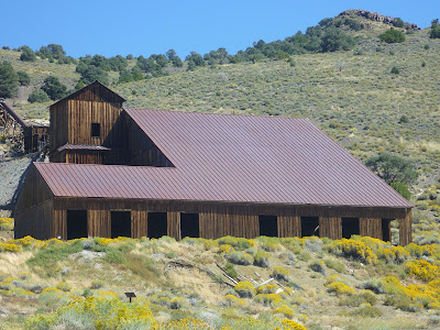
Berlin Mill


A look inside the mill

The forest you see around Berlin is mostly second growth. The Guide explains that during the activity at the Berlin Mine, nearly every large pinyon and juniper between Grantsville and Ione was felled to feed the boilers and steam engines at the mine and mill. In the Berlin Mill picture you can spot some trees up the hills in the background. 

Ore processing in the mill always left mill tailings behind, which still contained gold. The tailing values were recovered in 1910 by using a cyanide plant .  

Machine Shop

This building contained the blacksmith shop, and was equipped with power driven drill presses, and lathes, etc. Therefore, it was called the machine shop. The crew of mechanics that worked here kept all the mine and mill machinery running smoothly.

Occasionally a passing automobile that had broken down was towed to its door to be put into running condition again.

Machine Shop

Obviously, some mining tools and machinery is displayed around. But the Guide says that all of the major equipment and machinery was sold and hauled away during the scrap metal drives during Worl War II.


Stage Station

The stage driver and his horses were housed under one roof in this building. A partition made of lumber separated the dwelling section from the barn. A small corral was attached to the south section and the door leading into the barn could be closed in cold weather.

The men who drove stage from 1904 until 1924 were John Mullin. Ed Dieringer and Alex Dyer.. Alex used horses until 1915. On his first trip by Model T, the car quit him at the Dieringer Ranch. He caught a ride into Ione for help, and Albert Mayette and Firmin Bruner drove him back to his car and got it started.

Stage Station


Assay Office

Samples of rock and ore from the mine and samples of concentrates from the mill were processed (assayed) here to determine the amount of values they contained. The furnace in this assay laboratory used charcoal because it was the only clean burning fuel produced locally.

The night watchman used this office to warm himself and to rest in after each trip through town on lookout for thieves and fires. He also ate his midnight lunch here. The watchman's name was Mr. Doolan.

Assay Office

The Clubhouse

The two-story building that stood here was called the “Clubhouse”. It might have been erected to house the mine and mill office. But during the years from 1906 to 1908, it was used as quarters for visiting company officials and local supervisors that did not have families. The bedrooms were upstairs and the lower floor was a lounge.

In the years following 1945, someone removed lumber from the partition walls, thus weakening the building, and it finally collapsed.

[Text by Firmin Bruner, a resident of Berlin - 1904]

What has been left of the “Clubhouse”

According to the Guide, alcohol and drinking was not permitted in Berlin. I wonder what visitors and supervisors did in their free time (if there was any) in the lounge? Did they frequent the four saloons located nearby, outside town? 

Getting there

From Reno, take I-80 to Fernley. Take exit 46 and continue east on Highway 50. Pass through Fallon and continue to the Middlegate Junction. Turn right onto Route 361 and go south for about 30 miles toward Gabbs. Take a left onto Nevada Route 844 and drive about 16 miles to the park entrance. 

Expect your travel time to be 4 hours. Maybe, a little less. Or more, if you take stops along your route — for example, at the Grimes Point Archaeological Site southeast of Fallon.


References and further reading

Berlin State Park. Berlin Town Guide, funded by the Wilhelm Hoppe Family Trust. Available for free at the Berlin Visitor Center (Mine Superintendent's House).

Berlin. Forgotten Nevada. URL: https://forgottennevada.org/sites/berlin.html.

Berlin, Nye Country. Nevada Expeditions. URL: https://www.nvexpeditions.com/nye/berlin.php.

Deborah Wall: Berlin-Ichthyosaur park offers a stunning look at history. Las Vegas Review-Journal, May 15, 2017. URL: https://www.reviewjournal.com/local/local-columns/deborah-wall/berlin-ichthyosaur-park-offers-a-stunning-look-at-history/.

Eric Cachinero: Mine Mechanics. Nevada Magazine, January - February 2019.URL: https://nevadamagazine.com/issue/january-february-2019/8260/.

Note: all listed websites were accessed on September 30, 2023.


Keywords

Berlin Mine, turn-of-the-century mining town, mining history, central Nevada.


Saturday, June 24, 2023

Sugar Pine Reservoir loop trail: hiking & more northeast of Foresthill in the Sierra Nevada, California

Flooded Forbes Creek at Sugar Pine Reservoir

The Sugar Pine Dam, constructed between 1979 and 1982, is an earthfill embankment dam, located about seven miles northeast of Foresthill in Placer County, California [1]. The Sugar Pine Reservoir—let's just call it a lake from here on—supplies municipal water for the Foresthill community. It is a serene recreational site with swimming, fishing, watercrafting, hiking, bicycling, horseback riding and camping options. 

A four-mile-long hiking and bicycling trail “circles” the lake. Its perimeter is not circle-shaped: the loop trail winds around the lake by taking you out-and back around lake arms—flooded sections of former creeks. Forbes Creek and Shirttail Creek are tributaries to the lake. Past the dam, overflow water follows Shirttail Creek downstream into the North Fork American River.  

In June of this year I hiked around the lake—an easy walk. I started out counterclockwise from the boat ramp. About half-way around, I found various interpretive Tahoe National Forest panels next to the lake shore informing about the local history, geology and wildlife. In the following, I am sharing some of the pictures I took on my round trip by framing them with quotes and notes based on interesting panel text.   

The first panel I encountered had the title Under the Water. It takes us back to the days before the reservoir was built, inspiring us to ponder what being at this place may have been like at different times in the past:

When Shirttail Canyon and Forbes Creek were dammed to form Sugar Pine Reservoir, many Native American and historic sites were flooded. Local Native Americans used the area for hunting and gathering. Acorns were gathered and various seeds were processed by grinding bedrock milling stations. 

Historic use included mining and grazing. Shirttail Canyon was named by early miners. Two miners, Tuttle and Van Zandt, discovered a lone miner in the canyon wearing only a short shirt. They asked the miner, “what in the devil's name do you call this place” The lone miner laughingly answered, “Don't know any name for it yet, but we might as well call it Shirt-tail as anything else.”

Old fence lines associated with grazing can still be seen. Historic maps indicate that a road and an unidentified building were flooded.


View from the Under the Water panel: reservoir water now covering Native American and historic mining and grazing sites

Continuing on, you will see panels that describe how ospreys live and fish, and how fallen trees sustain the forest around the lake and beyond. Then, there comes the panel with the title Contribution to the Great War:

Chromite, a mineral found in the Sugar Pine area, was a critical resource during World War I. Ferrochrome, which is made from chromite and steel, was used as armor plating for tanks and equipment.

Chromite mining in this area began in 1876, but was most active, and most important, from 1917 to 1919 to support the war effort.


Shirttail creek bridge
Near the Shirttail creek bridge you may notice an area of thinned forest, where a panel explains that in 2010 small trees and shrubs were removed to leave the remaining forest healthier and better able to survive drought and wildfire. In 1936, the McKenzie Mill fire swept through the area and burnt most of the trees.

Walk across the bridge, enter the cedar grove and find the cedar tree with burn marks (fire scars). This tree survived the fire thanks to its thick insulating bark. Fire intensity is key to the outcome of a forest fire:

When wildfires burn too hot and out of control, they can devastate a forest. However, fire plays an important role in the forest ecosystem. Low-intensity fire helps “clean house” by burning up dead material and making more nutrients and water available for trees and plants to grow stronger and healthier. Some trees and plants actually need fire to release their seeds.

A nearby panel about the local Nisenan People says that “in the fall, the Nisenan would often set the ground litter and vegetation on fire. Since these fires were low intensity, large trees were unharmed. The burning improved the growth of grasses which supported and attracted the animals they hunted..”


Sprays of cedar branchlets at Shirttail Creek near the Manzanita Day Use Area 

After scanning the old cedar canopy and enjoying the fresh green of many young cedar trees, I left the cedar grove and came to the forest edge, an almost treeless area of pale green serpentine rock. Serpentine minerals are hydrous magnesium iron phyllosilicates. Serpentine is the California State RockGeology Created this Forest Edge is the panel title here, reading:

Serpentine rock creates soil that is toxic to most plants. This is especially noticeable at a forest edge like this one.

On serpentine soil, trees are sparse and there are large areas of bare rock. Where the composition of the soil changes to andesitic (volcanic) based soil, plants and trees are more abundant.

The change from bare ground to tree cover is often so abrupt that foresters and soil scientists can map general soil types using aerial photos [like the one shown on the panel].


A serpentine rock at the forest edge

Evergreen manzanita shrubs are not only drought-resistant, obviously they tolerate serpentine soil. You will find them here: the area is even called Manzanita Day Use Area.

Northeast corner with the Manzanita Day Use Area where fresh Shirttail Creek water is filling the reservoir 


Okay, the last panel (it could be your first if you are on a clockwise round trip) summarizes The Sugar Pine Story:

In 1982 Sugar Pine Reservoir was built to provide the town of Foresthill with a dependable water source. The reservoir is not only valuable to residents of Foresthill, but also to wildlife, fish, and recreationists.

The reservoir is named for the sugar pine tree, easily recognized by its gigantic cone. The sugar pine is not as common here today as it once was due to a combination of historic logging, a 1936 wildfire, and the spread of a disease that kills sugar pines called White Pine Blister Rust.


Continuing the round trip on the paved trail across the Giant Gap Campground, you will arrive at the point, where a sign indicated you have one mile to travel to the dam. That section is a panel-free, red-dirt single track. Expect some fallen rocks on the path.


Unpaved trail section between dam and Giant Gap Campground

The dam area is the western most tip of the reservoir. A short unpaved trail towards the boat ramp concludes the loop.


Note on name of the reservoir loop trail

The trail is frequently referred to as Joshua M. Hard Memorial Trail to honor Army Sgt. Joshua M. Hardt of Applegate, California. Joshua died at age 24 on October 3, 2009, while serving during “Operation Enduring Freedom” [2,3].


Getting to the boat ramp

Sugar Pine Reservoir is located northeast of the city of Auburn in the Sierra Nevada. From the historic mining town of Foresthill, continue northeast on Foresthill Road for about 10 miles. Turn left at the sign for the reservoir and drive downhill for 4 miles to get to the boat ramp parking and picnic areas. 

Address: Sugar Pine Reservoir, California 95631.


Boat ramp area of Sugar Pine Reservoir with dam in the back

On my visit in mid-June the reservoir was relatively quiet. But I was told larger crowds should be expected on hot summer weekends.


References and more

[1] Sugar Pine DamWikipedia. URL: https://en.wikipedia.org/wiki/Sugar_Pine_Dam.

[2] Army Sgt. Joshua M. Hardt  URL: https://thefallen.militarytimes.com/army-sgt-joshua-m-hardt/4316304.

[3] Joshua M. Hardt Memorial Trail at Sugar PineSingletracks. URL: https://www.singletracks.com/bike-trails/joshua-m-hardt-memorial-trail-at-sugar-pine/.

[4] Sugar Pine Reservoir. Recreation.gov. URL: https://www.recreation.gov/camping/gateways/2284.


Monday, June 12, 2023

Muscle Powered and blue-belly guarded: Bob's Trail

Bob's Trail Post at Four Day Trail junction: manzanita backdropped and blue-belly guarded
The three-mile-long Bob's Trail is your backbone trail through the Ash Canyon Trail System. Various side tracks add interest and challenges to the east-west oriented Bob's Trail, which connects the (limited) Foothill Drive parking space at the outskirts of Carson City, Nevada, with the trailhead of the Ash to Kings Trail

Bob's Trail's side trails are short single tracks, between 0.3 and 1.3 long, and have max grads up to 19%. They include:

It needs less than a day (depending on your mode of traveling: only a few hours) to visit, hike or bike all of them. And after each side trip you will always end up on Bob's Trail to get straight back to from where you started. Once the section between the ends of Eagle View Trail is completed, you'll have, for example, less than three miles back to Foothill Drive. 

Like the Eagle View Trail, Bob's Trail was built by Muscle Powered [1]:

Built by Muscle Powered at the beginning of 2018, Bob's Trail was named in honor of Robert “Bob” Crowell who was an advocate for trails and Open Space. Currently there are two segments of this trail with future plans to connect.  


Foothill Drive Gate: Bob's Trail starts here


Muscle Powered

Promoting a pedestrian- and bicycle-friendly infrastructurehttps://musclepowered.org


Map link

Ash Canyon Trail System maphttps://www.carson.org/home/showpublisheddocument/80022/637861499835270000


Reference

[1] Click the Bob's Trail tab on the Ash Canyon Trail System website or look for other trails within the trail networkhttps://www.carson.org/government/departments-g-z/parks-recreation-open-space/parks-and-places/trails/ash-canyon-area

Sunday, June 11, 2023

Four Day Trail

A curious blue-belly lizard hanging on to a Four Day Trail post

The 0.6-mile-long Four Day Trail leads through open forest between Evidence Trail and Bob's Trail in the Ash Canyon Trail System west of Carson City, Nevada. The trail system website describes the trail as follows [1]:

Named after the original fireman who built the trail with the license plate “Four Day”, the Four Day Trail is a stacked loop trail just below the Evidence Trail.


Expect hikers, mountain biker and horseback riders on Four Day Trail—and lizards.


Four Day Trail with views of lower Ash Canyon


Map link

Ash Canyon Trail System maphttps://www.carson.org/home/showpublisheddocument/80022/637861499835270000


Reference

[1] Click the Four Day Trail tab on the Ash Canyon Trail System website or look for other trails within the trail networkhttps://www.carson.org/government/departments-g-z/parks-recreation-open-space/parks-and-places/trails/ash-canyon-area.

Evidence Trail

Evidence Trail switchback with views into Ash Canyon

The one-mile-long Evidence Trail is a staked loop trail above the Four Day Trail in the Ash Canyon Trail System west of Carson City, Nevada. It is named after the Thelonious Monk tune “Evidence” [1]. There we go again: along with the Seven Steps Trail we found another single-track that derives its name from a jazz tune. What would have Miles Davis or Thelonious Monk made of their tune-to-trail-name fame?

Evidence Trail is open to hikers, mountain bicyclists, and horseback riders. Jazz musicians.are welcome!

Like Vicee Canyon Rim TrailSeven Steps Trail and Eagle View Trail,  Evidence Trail is a side track of Bob's trail.

In late spring, here, the air gives evidence of the many flowering tobacco brushes, which are growing on the surrounding slopes and deodorizing the environment with their spicy fragrance.  

Trailside Sego lilies


Map links

Map of westside Carson City with Vicee Canyonhttps://mapcarta.com/23374436/Map.

Ash Canyon Trail System maphttps://www.carson.org/home/showpublisheddocument/80022/637861499835270000


Reference

[1] Click the Evidence Trail tab on the Ash Canyon Trail System website or look for other trails within the trail networkhttps://www.carson.org/government/departments-g-z/parks-recreation-open-space/parks-and-places/trails/ash-canyon-area.

Eagle View Trail

Eagle View Trail

The 0.8-mile-long, single-track Eagle View Trail through wildlife habitat—mainly for mule deer and raptors—was built by Muscle Powered in 2019. This mountain biking and hiking trail circles around the “knob” of Eagle View Open Space with varying vistas and steep side slopes [1,2].

Eagle View Trail is part of the Ash Canyon Trail System near Carson City in northern Nevada. Like Vicee Canyon Rim Trail and Seven Steps Trail, it is a side track of Bob's trail. In fact, the section of Bob's Trail between the east and west ends of Eagle View Trail is marked as a “future connection” in the March 2022 map of the Ash Canyon Trail System. Such, Eagle View Trail is the “current detour” until this missing section is completed (which maybe it is, if the east-side trail post, shown on the left, can be trusted. I haven't found a matching west-side post yet.). Sooner than later, Bob's Trail will connect the Foothill Drive trailhead at Carson City's outskirts with the trailhead of the Ash to Kings Trail—providing a main-thread path between these two trailheads with multiple options of scenic side-tracking

The amazing views from Eagle View Trail will always be worth the detour.

 Vicee Canyon seen from Eagle View Trail. This canyon section is located west from the Vicee Canyon Rim Trail section.


Map links

Map of westside Carson City with Vicee Canyonhttps://mapcarta.com/23374436/Map.

Ash Canyon Trail System maphttps://www.carson.org/home/showpublisheddocument/80022/637861499835270000


References

[1] Click the Eagle View Trail tab on the Ash Canyon Trail System website or look for other trails within the trail networkhttps://www.carson.org/government/departments-g-z/parks-recreation-open-space/parks-and-places/trails/ash-canyon-area.

[2] Eagle's View Open Space favored as name for newest Carson City property. Lahontan Valley News, October 29, 2019: https://www.nevadaappeal.com/news/2019/oct/29/eagles-view-open-space-favored-as-name-for-newest-/.


A tune became a trail: Seven Steps Trail

Seven Steps Trail

The Seven Steps Trail is a continuation of the Vicee Canyon Rim Trail. Both trails are short single tracks—side trails to Bob's Trail—within the Ash Canyon Trail System west of Carson CityNevada.

The 0.3-mile-short Seven Steps Trail is open to hiking, mountain biking and equestrian activities. It connects the west-side end of  the Vicee Rim Trail with Bob's Trail—the main trail thread through the trail network connecting Carson City's Foothill Drive with the Ash-to-Kings trailhead. 

From Vicee Canyon, the Seven Steps Trail travels upward across an east-facing slope with views of Carson City. The trail has some step-like features. While hiking uphill and counting, I came to the conclusion that “seven steps” is a reasonable approximation. However, according to the trail website, the trail name is attributed to the tune of jazz musician Miles Davis: “Seven Steps to Heaven” (on a record released in 1963). 

The smell of trail heaven: sweetly fragrant flowers of tobacco brush

Once you are in heaven, it just takes a few steps downhill to get back onto Bob's Trail.


Map links

Map of westside Carson City with Vicee Canyonhttps://mapcarta.com/23374436/Map.

Ash Canyon Trail System maphttps://www.carson.org/home/showpublisheddocument/80022/637861499835270000


References

Click the Seven Steps Trail tab on the Ash Canyon Trail System website or look for other trails within the trail networkhttps://www.carson.org/government/departments-g-z/parks-recreation-open-space/parks-and-places/trails/ash-canyon-area.

Seven Steps to Heaven (Wikipedia, accessed on June 11, 2023): https://en.wikipedia.org/wiki/Seven_Steps_to_Heaven.