Sunday, April 28, 2019

Hickison Petroglyphs Interpretive Trail

Stairs to petroglyphs and vista points
The Hickison Petroglyph Recreation Area is a Great Basin prehistoric site located next to Highway 50 about 20 miles east of Austin, Nevada. When I arrived at the trailhead of the Hickison Petroglyphs Interpretive Trail on an early spring day in 2019, I made the same experience Valerie Norton described on a 2017 visit [1]: the brochure-box was empty and the panel with the trail gave no site details. Also, I couldn't find a website with a detailed map for the self-guided tour. Alongside the unpaved trail loop, sites were clearly marked by numbers. So, I keep my pictures marked accordingly with the hope of coming eventually across an interpretive map.

Hickison Petroglyphs Interpretive Trail between its trailhead and the first marked site
Lucky Gretchen: when she was visiting with her family, she found a brochure for pick-up and they all were in front of petroglyphs in just a couple of minutes [2]. She writes that the brochure describes the Hickison petroglyphys as typical of the Great Basin curvilinear style. Curvers and carvers are unknown.

Curvilinear carvings
The loop trail and the dead-end vista side trails make for a pleasant walk, traversing mostly open pine forest and providing easy access to the numbered petroglyph faces carved onto the rock slabs. There are distinctly different carvings: deeply carved, lightly carved, geometrically abstract and figure-representing. How much did erosion change the original carvings? How often were they modified or overscrawled? I think, I spotted some very recent “scribbles,” i.e. vandalizing scratchings.

The petroglyph site is named after ranch owner John Hickerson [3]. How did the name mutate to Hickison? The petroglyphs are said to give evidence of prehistoric hunting and dwelling sites dating back to 10,000 B.C., when the Great Basin was a “Great Lakes” area, including Lake Toyiabe and Lake Tonopah [3]. I wonder if the shorelines of those lakes were near the rock croppings in the period during which the Great Basin petroglyphs were created.

Rockscape view from vista point


Keywords: Nevada; Great Basin; National Forest; US Route 50; roadside attraction; prehistoric site.

Getting there

On your way from Austin to Eureka on Hwy 50, drive over Hickison Summit (6546 ft., 1995 m). Soon, on the left side of the road, you will see a large sign in the shape of an isosceles trapezoid with the longer of the parallel sides at the top. It reads “HICKISON PETROGLYPHS Recreation Area & Interpretive Site.” Turn left and follow the northwest-bound gravel road for a quarter-mile to the Interpretive Trail site and camping area [4,5].

Vista point canyon view south with Monitor Valley farther back


References

[1] Valerie Norton: Hickison Petroglyphs Interpretive Trail. “Moments in Dirt and Ink” Blog,  May 15, 2017. Link: valhikes.blogspot.com/2017/05/hickison-petroglyphs-interpretive-trail.html.
[2] Gretchen:  Hickison Petroglyph Recreation Area, Nevada. “Desert Survivor” Blog, October 17, 2017. Link: desertsurvivor.blogspot.com/2017/10/hickison-petroglyph-recreation-area.html.
[3] Hickison Petroglyph Reacreation Area. Travel Nevada. Link:travelnevada.com/discover/27113/hickison-petroglyph-recreation-area.
[4] Hickison Petroglyph Reacreation Area. Bureau of Land Management. Link: www.blm.gov/visit/hickison_petroglyph_recreation_area.
[5] Map of Hickison Summit area including Hickison Petroglyph Recreation Areahttps://www.google.com/maps/d/viewer?ll=39.446000000000005%2C-116.75170000000003&z=15&mid=1UvljiHxGw4ZlmWSOp3jm3wTpy7M.


Wednesday, March 20, 2019

Bowers Family Cemetery Trail

The Bowers Family Cemetery Trail is a well-maintained walk under trees—a short climb from the backside of Washoe County's Bowers Mansion to the Bowers Family grave site. The tombstone of Comstock millionaires Sandy and Eilley Bowers and their children is located at the end of the trail.

Pentagonal Bowers Family tombstone
On your way up, you will get a chance to view—through the pine trees —the mansion with its octagonal rooftop structure.

Bowers Mansion rooftop
From the grave-site platform, grand vistas of Washoe Lake and the Virginia Range can be enjoyed.

View of Washoe Lake and parts of the Virginia Range from grave site
Engraved in the pentagonal tombstone are the names of Lemuel Sanford Bowers (1833-1868), called Sandy Bowers, Alison Oram Bowers (1826-1903), called Eilley Bowers, and the names of their children, who died young: John, Theresia and Margaret Persia. Sandy died of miner's lung disease: silicosis.  Eilley outlived her husband (Sandy was her third one) and her children. In 1876, according to the onsite information kiosks, the mansion was put into foreclosure. The story goes that Mrs. Eilley Bowers—one of the richest women of America for some years—died penniless in Oakland, California.  

The Bowers Family Cemetery Trail starts with stairs.


 Address of the Bowers Mansion

4005 Old U.S. Highway 395
Washoe Valley, Nevada 89704


Getting there

Driving south on Old U.S. Highway 395, pass the Davis Creek Regional Park entrance and exit the “highway” at the Bowers Mansion Regional Park sign (shown to the left). Continue southward on the park road past the mansion grounds and find parking in the paved area at the end of the road. A short walk across the play ground and picnic greens takes you to the backside of the mansion. The marked trail to the hillside graveyard starts next to the Bowers Root Cellar building.

Bowers Mansion phone number: (775) 849-0201.


More to explore

Bowers Mansion Tombstones, Washoe County, Nevada. Photos by Holly Hart of Oxnard, California. Link: www.usgwarchives.net/nv/washoe/photos/tombstones/bowers/bowers.html.
Allison “Eilley” Oram Bowers. Find A Grave. Link: www.findagrave.com/memorial/24651681/allison-bowers.  
Lemuel Sanford “Sandy” Bowers. Find A Grave. Link: www.findagrave.com/memorial/24651675/lemuel-sanford-bowers.
Bowers Mansion. National Park Service. Link: www.nps.gov/nr/travel/nevada/bow.htm.

Wednesday, March 13, 2019

Deadman's Creek Trail southeast of Washoe Lake: the gazebo loop

Gazebo southest of Washoe Lake
The gazebo above Deadman's Creek's riparian zone with snowstorm-swept Slide Mountain in the background (March 8, 2019)
Deadman's Creek Trail consists of a short path through riparian habitat—the interpretive nature trail section—and a loop meandering through an opening canyon uphill to a gazebo vista point. Hikers can enjoy spectacular views of Washoe Lake and the Carson Range throughout the year. A small board posted near the trailhead describes the trail as follows:
This trail takes hikers through a riparian zone along the spring-fed Deadman's Creek. At the trail intersection, the right branch takes hikers to a gazebo overlooking Washoe Valley and Washoe Lake. The left branch follows the canyon up to a dirt road where hikers can further explore the area.
Riparian zone with dead-tree-gate

This is a moderate trail with a short, steep climb to the gazebo (an elevation gain of approximately 380 feet).

The trail name refers to the mysterious death of two ranch partners at Dead Man's Ranch, mentioned in a book with the title “Pioneers of the Ponderosa: How Washoe Valley Rescued the Comstock,” written by Myra Sauer Ratay (1912-199), born in Franktown in the southwest corner of Washoe Lake.
Small rock shelter with lichen and icicles
The lower trail section features various informative panels posted next to native plants. If you follow the trail on the left side of the creek, you will soon get to an Y-junction. The left branch takes you out of the canyon to the mentioned dirt road. The right branch crosses the creek and bends southwest, passing various boulders and rock outcrops—one with a rock shelter—before leading further uphill to the gazebo. 

View of Washoe Lake (left) and the sand dune landscape with flooded areas (lower right)


Getting to the Deadman's Creek Trailhead

Driving south on I-580/U.S.395, exit the freeway southwest of Washoe Lake to get to Washoe Lake State Park. Go east on Eastlake Bouevard. Watch out for a few crosses on the right side of the road with a small parking area in front—less than a mile east from the Wetlands Loop trailhead and about half a mile before you would arrive at the visitor center. To get a local overview, find Deadman's Creek Trail (colored in blue) in the lower right section of the Washoe Lake State Park map.

Friday, February 1, 2019

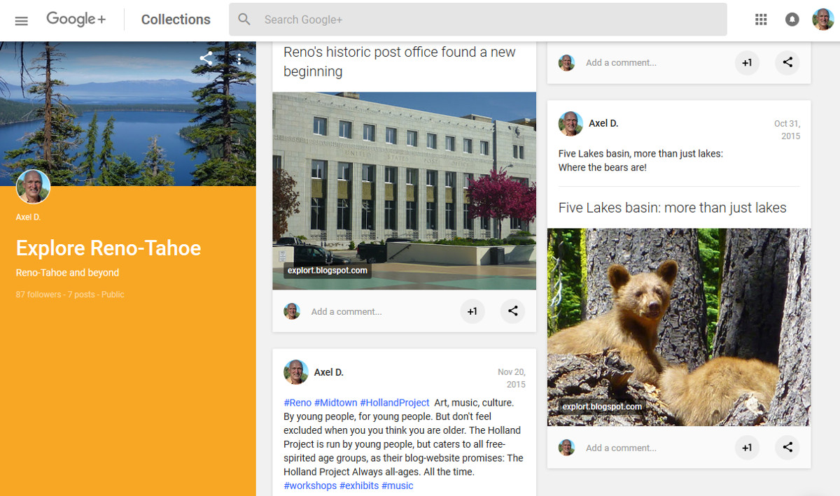
Goodbye Google+

Gone after April 2, 2019: my Google+ Account (like all other consumer accounts)

My Explore Reno-Tahoe collection including my favorite black bear snapshot and a picture of Reno's historic post office

My Recreating Outdoors collection including links to my posts about the Point Reyes' Kule Loklo Trail and Kehoe Beachside Geology

I have a personal Google+ account, which is going away on April 2, 2019 [1]. This is not an April Fools Day prank. Google+ for “consumers” will be shut down [2].  The reason for the G+ suspension are low user engagement and Google's internal investigation (Project Strobe) resulting in privacy concerns related to the access that third-party developer have on Google and Android products [3-5].

The Google+ Team send me an email with a link to download my Google+ content in archived format, including +1 websites (liked websites) as well as circle and stream data.

To share and keep in memory my Google+ Profile and my collections, I above show selected screenshots.

In addition to posting to Trailing Ahead, I continue publishing on Explore Reno-Tahoe and beyondLatintos and Axeleratio—and share pictures via Twitter (@travelingahead), Pinterest (TrailingAhead) and Tumblr (Axeleratio). More about me at www.axeleratio.com/axel.

Here, I like to take the opportunity to thank all my readers; those, in particular, who contacted me forwarding comments and supplementary information or inquiring about re-publishing a liked post in a local newsletter. 


Keywords: social networking, Google PlusGoogle+ shutdown, G+.

References

[1] My Google+ Home Page “always between borders, bonds and bytes” still available through February and March of 2019: https://plus.google.com/113418081893311820936.
[2] Google+ profile and page suspension. Google+ Help. Link: support.google.com/plus/answer/6320424?hl=en.
[3] Ryan Whitwam: Google+ Will Shut Down in 2019 After Exposing User Data. ExtremeTech, Oct. 8, 2018. Link: www.extremetech.com/internet/278352-google-will-shut-down-in-2019-after-exposing-user-data.
[4] Swapna Krishna: Google is shutting down Google+ following massive data exposure. engadget, Oct 8, 2018. Link: www.engadget.com/2018/10/08/google-shutting-down-google-plus/.
[5] Mike Allton: Goodbye Google+. Google Shuts Down Google+. TheSocialMediaHat.com. Link: www.thesocialmediahat.com/news/google-officially-done-10082018.


Friday, December 28, 2018

Around the Nevada “N”-—the Thorton Point Loop


Thorton Point: view of downton Reno, Huffaker Hills and Virginia Range
The Thorton Point Loop is a round trail within the section of Rancho San Rafael Park stretching into the Peavine Mountain foothills north of N McCarran Blvd. This is a popular hiking and mountain biking area just a few miles away from the campus of the University of Nevada, Reno (UNR). UNR students maintain and paint the rocks that form the hillside letter_“N” with its slab serifs.
 Nevada “N” —slab-serif-typefaced
“N” trail signRecently, I noticed the trail-map entryThorton Point Loop 4.0 mi” in the Evans Canyon Trailhead map displayed at the kiosk in the Reno Softball Complex/Disc Golf Course parking area. Older maps just show(ed) Thorton Point (if at all). Anyway, walk from the trailhead to the Basque Sheepherder Monument and you will see the “N” slope with the Thorton Point rock outcrops crowning the Nevada “N” site. From the monument, hike downhill to Evans Canyon grove where a Nature Trail circles through the tiny forest alongside creek banks. Cross Evans Creek and go upward on Miners Canyon Trail/ “N” Trail leading to the “N” site. Before getting to the letter baseline, turn right at the intersection you can see in the upper section of the picture below.
“N” Trail
Upward to the Nevada “N” and Thorton Point

Mizpah mine tailings
Pass the tailings of the Reno Mizpah Mining Co. site (in the small canyon to your right).
Continue ascending to the fenced-in NV Energy high-voltage facility. At the trail intersection next to the hazardous voltage site, turn left onto Reno Vista Trail. This trail traverses the area between the “N” and Thornton Point.


Thorton Point red rock with lichen and snow
Eventually, the vista trail bends left and descends to its junction with the Rancho Connector Trail (RCT). Continue downhill on the RCT into Coyote Canyon, ending at the Evans Canyon grove. From there, it only is a short distance to the Basque Monument and your starting point.

Trail Maps

Map showing four-mile-long Thorton Point Loop trail (displayed at Evans Canyon Trailhead kiosk):
Nevada “N” and Thorton Point


“Peavine Trails” map: https://www.reno.gov/home/showdocument?id=48300.
Find Thorton Point and the“N” in the lower right quadrant of this map. The Thorton Point Loop can be identified by following, clockwise, a section of  the Rancho Connector Trail, Reno Vista Trail, “N” Trail and Miners Cyn Trail.

Sunday, October 28, 2018

Olmstead Loop Trail

Olmstead Loop: a horse trail (also used by hikers, dog walkers and mountain bikers)

The Auburn State Recreation Area (ASRA) with the Olmstead Loop Trail is a trail el dorado in El Dorado County, California.

The Olmstead Loop is a nine-mile-long round-trip trail through the Sierra foothills between Highway 49 and the North Fork American River west of the community of Cool. The trail was named in 1993 for outdoor enthusiast and mountain biker Dan Olmstead, who owned and operated the Bike & Hike Shop in nearby Auburn.

Kiosk with Auburn State Recreation Area map
The “official trailhead”—the 0-mile point—of the loop trail is located at the St. Florian Court/Hwy 49 junction. The parking lot, equestrian staging area and an information kiosk with a trail map and a biographical sketch of Dan Olmstead are all located behind Fire Station 72 (proudly serving the Community of Cool). The Olmstead Loop Trail can also be accessed from the Cave Valley Gate at the Northside Elementary School about two miles south of Cool and the Catecroft Gate (Gate 158 near the Niegel Lane/Hwy 49 junction) about three miles south of Cool.

Olmstead Loop Trail
Olmstead Loop Trail near its junction with Cave Valley Trail
The section of the Olmstead Loop Trail that runs close and parallel to Hwy 49 passes through meadows with stands of oak and pine trees and a few blackberry patches. The section halfway between Hwy 49 and the North Fork American River includes two steep canyon descents/ascents: Knickerbocker Creek and Salt Creek. On a hot summer day, you certainly will welcome the shade and water you can find there (before the creeks may dry out in late summer).

The first three miles (if starting in Cool) take you to a line of four radio towers. Soon after passing the 3-mile post the trail bends north. Find the beautiful trail intersection, at which the Catecroft Trail (a shortcut from Gate 158) and the Luken's Mine Trail meet the loop trail. On your way to the westernmost point of the loop near McElroy's Spring, you will pass the 4-mile post.  Past the spring the trail soon descends into Knickerbocker Creek. Between the latter and Salt Creek you will cross a paved road. Instead of continuing the loop route, here you get the chance to shortcut and head east: back to the Cave Valley Gate or northeast to the fire station.

Reach the mile-6 post shortly before crossing Salt Creek. The twenty to thirty minute climb out of Salt Creek canyon on a dirt road gets you to the mile-7 post and the northwest tip of the loop. This is the Pointed Rocks area. Lichen-covered outcroppings of various size point towards the sky. The Training Hill Trail connects this place with the Western States Trail and the Wendell T. Robie Trail. To now conclude the loop (back to the fire station), it takes less than two miles—the last half mile or so with Cool in view.


References and more to explore

[1] Olmstead Loop Trail, description and trail map: https://www.canyonkeepers.org/tgolm.pdf [accessed Oct. 28, 2018].
[2] Jordan Summers: 60 Hikes within 60 Miles of Sacramento. Menasha Ridge Press, Birmingham, AL, 2008.; Hike 34, pp. 182-186.
[3] Ogre's Trail Guide to Northern California Mountain Biking > Olmstead Loop (Cool): ogrehut.com/trails.php/Sierra-Central/Cool/ [accessed Oct. 28, 2018].
[4] Cool Horse Trails > Olmstead Loop (part of the Auburn State Recreation Area): www.coolhorsetrails.com/olmstead_8.html [accessed Oct. 28, 2018].

Monday, July 30, 2018

Lily Lake to Susie Lake

Susie Lake with snow-covered parts of the Crystal Range in the far back
The trail from Lily Lake to Susie Lake is very popular with day-hikers and backpackers alike. Tourists and day-hikers may just walk to the Glen Alpine Springs Historical Site or continue to Grass Lake—a 2.7-mile-hike from Liky Lake (one-way). Climbing up to Susie Lake, Half Moon Lake or Mt. Tallac also are day options.

To get to Susie Lake, follow Glen Alpine Trail from the trailhead at Lily Lake to its junction with Grass Lake Trail. Proceed on the 1.8-mile-long section of Glen Alpine Trail (Trail 17E08 in the map below) to the junction with the Lake Aloha/Gilmore Lake trail post. Up to this point the route is the same as described for the Half Moon Lake hike.

Pond with lily pads next to Trail 17E32

trail post at 17E32/PCT-TRT junctionVeer left at the Lake Aloha/Gilmore Lake junction to follow the Lake Aloha direction (Trail 17E32 in the map). After passing various lily ponds, you will soon arrive at the 17E32/PCT-TRT junction (trail post shown on the left). Turn left (southwest) and descend to a beautiful meadow, which is densely covered with wildflowers including alpine tiger lilies. The first Susie Lake overlook is coming up soon. The PCT-TRT makes a half-circle around Susie Lake and then continues westward to Heather Lake and Lake Aloha. Susie Lake's shore allows for stunning views of Cracked Crag and Jack's Peak.


Maroon-spotted flowers of alpine tiger lily
 
Map of Susie Lake and surrounding lakes and trails including Half Moon Lake Trail (17E31)

More to explore about and around Susie Lake