Sunday, January 31, 2016

Snow Terraces Trail

Snow Terraces with Peavine mountain, Washoe County, Nevada
The short Snow Terraces Trail is part of the Peavine Trails network spanning a sagebrush-landscape northwest of Reno, Washoe County, Nevada. This trail connects the lower Poedunk Trail with the higher Halo Trail. The Snow Terraces Trail is used by hikers and mountain bicyclists to get—via Keystone Canyon Trail and Fisticuffs Trail—to the Halo and Bacon Strip Trail. Snowshoers enjoy this trail on those rare winter days on which the snow cover holds from the Snow Terraces all the way down to the Truckee river.

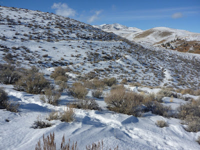
From the Snow Terraces Trail's junction with Poedunk Trail at Trail Marker 37, the single-track trail traces its uphill path along a few switchbacks. The higher you get, the more spectacular becomes the panoramic vista including the Red Hills, Reno and the Virginia Range further southeast. Also, the northern end of the Carson Range with Mt. Rose is coming into better view. Once you have passed the ridge, marked by an inclining dirt road, you will see the other side of the recreational Peavine landscape: the background scenery of Peavine Peak concludes the wavy topography of hills, ridges and canyons. The north-northeast-facing Snow Terraces are just a few steps away. Climbing the “terraces” (actually, it looks more like a stepped hillside) by following the switchbacks, you will soon find yourself on the Halo Trail—at Trail Marker 47

I am still waiting for the day, on which to observe a halo from this location; but in 2012 I found it to be a great spot for watching the solar eclipse

Peavine Peak surrounded by a wavy topography of hills, ridges and canyons
Peavine mountain in winter, seen from the Snow Terraces

Saturday, January 30, 2016

Poedunk Trail, west of Keystone Canyon Trail

Poedunk Trail traversing a typical Washoe County winter landscape with a half & half pattern—a northeast-facing, snowy slope next to a south-facing, snowfree hillside

The Poedunk Trail runs roughly parallel to the Keystone Canyon Trail. Connected via the Rancho Connector Trail (RCT), Fisticuffs Trail and Total Recall Trail, those two hiking and mountain biking trails form the major north-south axis of the current Peavine Trails network, which is projected to further grow westward onto the upper Peavine Mountain hills.

The Poedunk Trail, a single-track trail, is also open to horseback riding. This trail is named after the Poedunks (poedunk.org), a trail club affiliated with the International Mountain Bicycling Association (IMBA). According to the Poedunk website, the Reno-based Poedunks build and maintain non-motorized trails on Peavine in partnership with Washoe County Parks, the U.S. Forest Service, the City of Reno and other Peavine user groups. Let's congratulate them for what they have achieved so far!

All year round, you will come across mountain, snow or mud bicyclists on Peavine trails. I am also frequently meeting hikers and runners, but have never seen anyone horse riding within this open-space neighborhood northwest of Reno.

To get to the south-side “Poedunk Trailhead,” you may either start from the East Keystone Trailhead (see “Getting to the Keystone Canyon Trailhead” in my previous post “Keystone Canyon Trail”) or from the Middle Keystone Access area, just north of the Leadership Parkway. From East Keystone, follow the RCT northwestward, from Middle Keystone, follow the RCT northward: the Poedunk Trailhead is the RCT/Poedunk Trail junction at Trail Marker 34. Go north-northwest on Poedunk Trail. Very soon, you are going to arrive at what looks like a five-trail junction, marked by Trail Marker 35. The steep, dirt-road incline to your left is a non-recommended short-cut to the Halo Trail's Stonehendge section. The two trails to the right are inofficial connections with the Keystone Canyon Trail.

Bullet craters in mapped Peavine landscape
Continuing north on Poedunk Trail for about one mile, you will get to its junction with the Fisticuffs Trail at Marker 36. Further uphill, you will find a vista bench with views of the Truckee Meadows, Huffaker Hills and horizonal Virgina Range. Nearby on this saddle is Marker 37, from where the Snow Terraces Trail winds uphill to the Snow Terraces and Halo Trail. Continuing downhill on Poedunk Trail for about half a mile, you will come to its intersection with dirt road 21535—at Trail Marker 38, next to a former staging area, which was used as a target shooting platform. Now, this is a declared “Congested Area” and the discharge of firearms is prohibited. But bullet holes in the displayed map of prohibited and restricted areas in the Peavine foothills indicate some recent discharge. One bullet almost punched through the “You Are Here” point. From here, Poedunk Trail winds further downhill, passes a small pine grove and continues alongside a creek until it ends at its junction with the Total Recall Trail—at Trail Marker 39.

The east-side branch of Total Recall Trail connects with Keystone Canyon Trail. If you are ready for a larger loop, climb northwest on Total Recall Trail to Trail Marker 49, from where you can return to marker 37 via many switchbacks along Halo Trail and then Snow Terrace Trail. 

Poedunk Trail near its junction with Total Recall Trail

Sunday, January 24, 2016

Keystone Canyon Trail, Reno, Nevada

Peavine Mountain foothills with Keystone Canyon Trail
The Keystone Canyon Trail connects the East Keystone Trailhead next to the Leadership Parkway in north Reno with the Hoge Road Trailhead, located further north, east of the Lower Radio Towers. This is a hiking, running and mountain bicycling trail, including a trail-side rock outcrop for rock climbing beginners. The Keystone Canyon Trail is the gateway to various single-track trails over the foothills and through the canyons of Peavine Mountain. It also makes for a great snowshoeing trail on those rare winter days during which fresh snow cover does not instantly melt away.

Keystone Canyon stretches north-south, roughly dividing the lower-elevation regions east of Peavine Mountain into the steep West-Keystone hills and the eastern hills of the Rancho San Rafael Park landscape. At the beginning of the Keystone Canyon Trail you will pass junctions, from where trails connect with the western Keystone Canyon Recreation Area and with Coyote Canyon and Evans Creek in Rancho San Rafael Park. Find informative panels on the right side of the trail briefly describing northern Nevada's Sierra/Peavine geology, reflecting on the local human history, and highlighting the local flora, fauna and restoration efforts.

After half a mile or so along the gravel-road section of the trail you will get to Trail Marker 25, where the Fisticufss Trail (spelling at marker) branches off to the left, inviting you to venture uphill towards Poedunk Trail and to the Snow Terraces and Halo Trail. If you continue through the now narrowing canyon for another half-mile, you will reach Trail Marker 60, where the Recall Ridge Trail branches off on your left and becomes Total Recall Trail further northwest. Along the canyon trail, you will soon get to Trail Marker 26, where the right-side UNR DH Trail provides you with various loop option to return to the Keystone Canyon Trailhead via Rancho San Rafael paths.


Getting to the Keystone Canyon Trailhead (East Keystone)
From the intersection of North McCarran Boulevard and North Virginia Street, drive west for one mile and turn right on Leadership Parkway. Continue westward on Leadership Pkwy below the painted water tank for about half a mile. Turn right at the upright stone displaying the trailhead name in all-uppercase letters:  KEYSTONE CANYON TRAILHEAD. At the end of the parking area is a kiosk showing a trail map and other information of interest.
A Peavine multiuse trail map is available at the Poedunk web site at www.poedunk.org/poeville-89503/peavine-trail-maps.

Keystone Canyon Trail Map: this is a section 
of an older map displayed at the trailhead and 
not showing the now-open Poedunk Trail

Friday, December 4, 2015

Once added to the edge of North America

Mastodon sketch along Keystone Canyon Trail
The Peavine Mountain and its foothills northwest of Reno, Washoe County, Nevada, are today a popular recreation landscape, where locals and visitors come for hiking, horseback riding as well as mountain and dirt biking adventures. Since the area is mostly devoid of trees, great views of the Truckee Meadows, Red Hills, Virginia Range and Mount Rose Wilderness can be enjoyed.

Traveling Keystone Canyon Trail, you will pass a mastodon sketched on an informative panel, which explains in brief how the Peavine area and northwest Nevada was formed geologically:

About 200 million years ago, the rocks you see to the west were at the ocean floor. The North American continent was to the east. Underneath the surface, tension was mounting as the oceanic crust converged with the continental crust of the North American plate.

The ocean plate was forced down, under the western edge of the continental plate, turning the peaceful landscape into a chaotic jumble of activity. For millions of years the plates converged, scraping off oceanic rock onto the edge of the continent, and melting some of the oceanic crust that was forced deep into earth. As the shoreline extended westward, rocks that now form the Sierra Nevada Range and Peavine Mountain were beeing added to the edge of the continent.

About 20 million years ago, the region east of the Sierras began to be stretched apart, breaking up the crust into blocks. More recently, probably starting less than 5 million years ago, much of the Carson Range was uplifted.

Fossil discoveries indicate that Nevada was once home to large mammals such as elephantlike mastodons. The panel says:

2.5 million years ago the land of this region was flatter - lush and green, with plenty of lakes, and active volcanoes. It was a different world - not recognizable as the Peavine Mountain we know today. Many of the plants and animals would be strange to us - like the large furry, elephant-size MASTODONS that foraged on the lush vegetation.

About 10 years ago, the Peavine foothills were still cluttered with car wrecks. They were removed from hillsides and canyons. Corroding metal assemblies would be strange to us now. Steep, hillside-eroding dirt roads are getting replaced by switchbacking single-track trails. Non-motorized recreation activities are extending westward, building a recreational trail network from Reno to Verdi and into California all the way to the edge of the continent.  

Sunday, October 11, 2015

From the southern tip of Fallen Leaf Lake to Angora Ridge & Lakes: Angora Lake Trail

View of Fallen Leaf Lake and Lake Tahoe from upper Angora Lake Trail
Angora Lake Trail
The Angora Lake Trail connects the southern tip of Fallen Leaf Lake with the Angora Ridge between Tahoe Mountain and Angora Peak, south of Lake Tahoe in California. The steep single-track trail ascends through mixed forest. Warm up by climbing the easy-to-follow, but rocky switchbacks. Once you get closer to the ridge, the trail turns into a soft, needle-covered forest path. Take a break without missing the opportunity of  far-reaching views—framed by conifer trunks and branches—across Fallen Leaf Lake and Lake Tahoe towards the northern peaks of the Carson Range.

From the ridge, it is only a short, level hike to the parking area of the Angora Lakes Resort. Your effort to come up here from a public parking lot at Fallen Leaf Lake will save you the $7 parking fee at the resort entrance (and a bumpy ride over the rough Angora Ridge Road). The unpaved resort path leads uphill to the lower Angora Lake, with several cabins to your left. The public path continues alongside the lake. A short incline leads to the upper Angora Lake, which is semicircularly surrounded by rustic cabins, while the opposite lake side is bordered by steep slopes and cliffs.

Lower Angora Lake, early October 2015
The north side of the upper Angora Lake has a public beach, inviting visitors to wade through the shallow waters. If you brought your swimsuit, you may want to swim across the deep blue spots in the lake toward the rock walls. There are no lifeguards on duty. A notice warns about the danger of off-cliff jumping,with injuries and fatalities happening each season. Simply, enjoy the marvelous view of backdropping Echo Peak from the water or the shoreline or—during resort season—from a rented boat or the lemonade stand.  
The shallow water of the upper Angora Lake

Getting to the Angora Lake trailhead west of the Fallen Leaf Lake Marina and Store

The trailhead is located between the Fallen Leaf Chapel and the Fallen Leaf Fire Station next to Fallen Leaf Road. The writing on the trailhead sign is fading and needs some fresh paint to better contrast its background.

To get there, go south on Fallen Leaf Road from its junction with Highway 89, just west of Camp Richardson at the outskirts of South Lake Tahoe. Follow Fallen Leaf Road for about 4.5 miles. Alongside Fallen Leaf Lake, this is a narrow single-lane road through lake-side neighborhoods with turn-outs. At the lake's end, the chapel and fire station is on the left side of the road. If you don't find parking there, consider taking the paved, narrow road—uphill and alongside Glen Alpine Creek—to the public parking area at the Glen Alpine trailhead and walk back the half mile to the Angora Lake trailhead.  

Saturday, October 10, 2015

Sticky monkeyflower growing in the shrubland of Rancho Corral de Tierra

Orange bush monkeyflower
A pair of tubular flowers of Mimulus aurantiacus, growing in Rancho Corral de Tierra
Rancho Corral de Tierra is rugged, chaparral-covered land between the upper ridges of the Montara Mountain and the Pacific coast in San Mateo County, California. Easily accessible, but steep trails, including French Trail and Clipper Ridge Trail, invite hikers to explore this open space terrain south of San Francisco. From almost everywhere along the Rancho ridges, the ocean vistas are breathtaking. Endangered and endemic species such as Hickman's cinquefoil and invasive species such as pampas grass from South America occur in Rancho. Also, sticky monkeyflower (Mimulus aurantiacus) with its deep green sticky leaves grows and blooms on the dry soil of the rocky hillsides in Rancho, usually between March and September. Its long blooming season benefits nectar-thirsty hummingbirds for half the year.

Sticky monkeyflower is found throughout California and beyond, with flowers varying in color from pinkish white to brilliant red. The most common corolla color is yellow-orange. This color and the fact that plants grows up into branched shrubs explains the other name: orange bush monkeyflower.

The tubular flowers of the bush monkeyflower typically come in pairs. The picture above shows a pair of yellow-orange flowers of a plant found next to the upper Clipper Ridge Trail in mid-September. The picture also shows the opposite, lanceolate leaves with rolled-under edges.

Note: Depending on which of my field guides I am consulting, I am finding Minumuls aurantiacus, pronounced MIM-yoo-lus aw-ran-TIE-a-kus, grouped within the lopseed family (Phrymaceae) or within the snapdragon family or figworth family (Scrophulariaceae). My understanding is that Mimulus species had traditionally been placed in Scrophulariaceae, but are now classified as Phrymaceae based on DNA studies shining new light on phylogenetic relationships (see, for example, a paper by Beardsley and Olmstead in the American Journal of Botanty 2002, 89(7), pp. 1093-1102: Redefining Phrymaceae: The Placement of Mimulus, Tribe Mimuleae, and Phryma). Not enough, the scientific name has been changed from Mimulus aurantiacus to Diplacus aurantiacus: Welcome to monkeyflower science!

More about Mimulus aurantiacus:
Golden Gate National Parks Conservancy: Mimulus aurantiacus (Sticky Monkeyflower) [www.parksconservancy.org/conservation/plants-animals/native-plant-information/sticky-monkeyflower.html].
California Phenology Project: Sticky Monkeyflower (Diplacus auratiacus) [www.usanpn.org/cpp/MIAU].
Michael L. Charters: Mimulus aurantiacus Curtis [www.calflora.net/bloomingplants/bushmonkeyflower.html].

Thursday, October 8, 2015

A hiking loop in the Rancho Corral de Tierra foothills: French Trail and Clipper Ridge Trail

Clipper Ridge Trail's steep downhill path through chaparral with Princeton and the Pillar Point Peninsula at the bottom
About one mile north of Pillar Point Harbor, several trails crisscross the foothills at the southern end of Rancho Corral de Tierra. A few trails lead uphill, traversing steep slopes and long ridges. They are flanked by tangled shrubs and, in many places, by nonnative pampas grass. The views are spectacular: Montara Mountain further north, Princeton-by-the-Sea just “down the hill” and Half Moon Bay in the south. French Trail and Clipper Ridge Trail are rough dirt-road tracks through the Rancho area between Denniston Creek and Deer Creek. They make the upper Rancho terrain accessible.  

Invasive elegance of pampas grass
For a clockwise loop hike, follow the northwest-bound trail beginning at the end of Coral Reef Avenue. Pass its junction with Flat Top Trail and continue on the uphill trail you are seeing ahead of you. There are some trail markers, but until now I haven't found trail names posted at junctions or intersections. Fortunately, this is open space with an open view, supporting orientational place recognition and trail spotting.

Upper Clipper Ridge Trail
After climbing French Trail for about half a mile, you'll find a sign on your left, saying that there is no access to the “agricultural protection area.” Keep climbing. After about another mile, the French Trail meets the Clipper Ridge Trail. Before turning right and returning downhill, you may want to continue uphill for another mile to reach the level section of Clipper Ridge Trail with trees, shade and magnificent vistas. Further east, Clipper Ridge Trail bends into Deer Creek Trail, which goes downhill into Quarry Park and El Granada neighborhoods.

From the French Trail/Clipper Ridge Trail junction, you passed earlier, Clipper Ridge Trail starts its steep downhill course—shown in the top picture. After about one mile of descend, you will arrive at the junction with Flat Top Trail and Almeira Trail. Hike right on Flat Top Trail and at the next junction turn left and take the trail that takes you straight through a stand of eucalyptus trees to the starting point at Coral Reef Avenue.  


Getting there
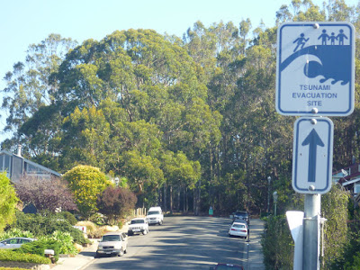
Rancho Corral de Tierra is located about ten miles south of San Francisco, California. From Highway 1 (Cabrillo Hwy), about half a mile northwest from the traffic-light intersection between Princeton and El Granada, turn right on Coral Reef Avenue. Follow this road uphill to its end, which is a tsunami evacuation site with a few parking spots.

From Cabrillo Hwy to Rancho trailheads: Coral Reef Avenue
Trailheads and tsunami evacuation site at the upper end of Coral Reef Avenue