Monday, November 14, 2011

Spanish Springs Trailhead has been dedicated


One, two, three ... the Spanish Springs Trailhead has been dedicated in the presence of a small crowd on a sunny Saturday morning. This trailhead will provide future access to trails through open space along the west side of Spanish Springs Valley in Washoe County, Nevada. Currently,  there are existing dirt roads and crisscrossing tracks. Trails still have to be designed and built. The site offers great views across the valley to Sugarloaf Peak and to the Pah Rah and Virginia Range further southeast. Spanish Springs Trailhead may eventually be a gateway for hikers, mountain bikers and horse riders to an area much larger than the currently targeted 330 acres, which are part of Bureau of Land Management (BLM) land. These acres are surrounded by further BLM land and the Reno Sparks Indian Colony to the north. Hopefully, trail connections to Lemmon Valley and the envisioned Sun Valley Rim Trail will become true.


Getting there
From Sparks drive north on Highway 445 (Pyramid Highway), pass Lazy 5 Regional Park and turn left on Eagle Canyon Driven. After about two miles turn right on West Calle de la Plata (direction for Spanish Springs Airport) and then turn left on Fuggles Drive. Carefully drive through the neighborhood, turn left on Kinglet Drive, drive uphill to the end of the road and housing development and find parking to your right.


Altered andesite buckwheat in the vicinity of Reno


Altered andesite buckwheat (Eriogonum robustum) of the buckwheat family (Polygonaceae) is a narrowly restricted endemic that occurs in hydrothermally altered andesite areas of the Reno/Sparks area in northwestern Nevada [1-3]. The shown plants grow in Reno's Red Hill area.

Altered andesite buckwheat can be found on dry andesite soil at low elevation including the Red Hill area and slopes of Mt. Peavine and the Geiger Grade [2]. Notice that it also is known under the vernacular name Geiger Grade buckwheat. The plants have leaves that are matted with felty hairs, resulting in a greenish white to silver color.

Altered andesite buckwheat is closely related to Lobb's buckwheat (Eriogonum lobbii), which is found at higher elevation: Whereas Lobb's buckwheat is locally common in alpine and subalpine environments, altered andesite buckwheat is narrowly restricted to cold-desert environments [1].

Andesite is a very finely crystalline extrusive rock of volcanic origin, solidified from molten lava at the Earth's surface. In composition, andesite can be considered an intermediate between basalt and rhyolite: it is composed largely of plagioclase feldspar with smaller amounts of dark-colored mineral [4,5]. Andesite is typically lighter colored than basalt, having a color from dark gray-green to lighter gray, brown or red. The name Red Hill makes a reference to the rust-red color of its hill sides.  

Keywords: botany, biogeography, taxonomy, geology

References and more to explore
[1] K. F. Kuyper, U. Yandell and R. S. Nowak: On the taxonomic status of Eriogonum robustum (Polygonaceae), a rare endemic in Western Nevada. Great Basin Naturalist 1997, 57 (1), pp. 1-10 [ojs.lib.byu.edu/wnan/index.php/wnan/article/viewFile/730/1578].
[2] Laird R. Blackwell: Tahoe WildflowersA Month-by-Month Guide to Wildflowers in the Tahoe Basin and Surrounding Areas. A Falcon Guide, Morris Book Publishing, LLC, 2007; page 53.
[3] J. D. Morefield: Current Knowledge and Conservation Status of Eriogonum robustum E. Greene (Polygonaceae), the altered andesite buckwheat. Nevada Natural Heritage Program, Department of Conservation and Natural Resources, 1550 East College Parkway, suite 145, Carson City, NV 89706, December 2000 [heritage.nv.gov/reports/errotext.pdf].
[4] Dictionary of Geology & Mineralogy. Second Edition McGrawHill, New York, 2003.
[5] J. V. Tingley, K. A. Pizarro, C. Ross, B. W. Putkey and L. J. Garside: Geologic and Natural History Tours in the Reno Area. Nevada Bureau of Mines and Geology, University of Nevada, Reno, 2005.


Sunday, November 6, 2011

To the top of Slide Mountain

Mount Rose Ski Tahoe is a ski resort in the Carson Range between Lake Tahoe and Reno/Sparks in Nevada. The actual ski facilities are located around the north-facing slopes of Slide Mountain, which, with an elevation of about 9,700 feet, is not as high as Mt. Rose with an elevation above 10,500 feet. Whereas Mt. Rose, nearby Tahoe Meadows and the Tahoe Rim Trail (TRT) are summer destinations for scenic hiking, Slide Mountain is the hot spot of the snow season, during which ski lifts take you to the top. Hiking the top of Slide Mountain, which is loaded with towers, antennas, various buildings, cable wheels and the upper stations of chairlifts, is not too popular, but possible. From the Mt. Rose Campground it takes less than an hour to ascend a dirt road (service road, normally without motorized traffic in summer) to the top. There, you get nice views of Mt. Rose, Truckee Meadows and the Virginia Range. Boards, displaying panoramic maps of the mountain slopes, introduce the ski bowls and downhill courses— from beginner to expert runs—with self-explaining names like Macho Bowl, Waterfall, Six Gun, Bullwhip and Wild Card.   

Getting to Mt. Rose Campground (closed in winter)
The campground is located a short distance off State Route 431, across the Mt. Rose Summit parking area. To avoid crossing the highway, parking at the Tahoe Meadows Trailhead is suggested. From there, go northeast, follow the TRT and Mt. Rose Campground Trail (length 0.4 mi) to the campground, cross the campground and turn right on the service road.


Tuesday, November 1, 2011

Pinemat manzanita (Arctostaphylos nevadensis) in the Carson Range


So Many Manzanitas. That is the title of a chapter in a book about gardening of native plants in California [1].  There are over 50 manzanita species (Genus: Arctostaphylos, belonging to the heath family, Ericaceae) and many have been considered for horticulture.

Manzanitas are native to California, Oregon and bordering areas including some corners of Nevada [1-4]. Pinemat manzanita is a mountain dweller loving open slopes and rock terraces in coniferous forests. The shrubs shown here grow next to the Tahoe Rim Trail at an elevation above 7,500 feet, south of Heavenly in the Carson Range, a few miles away from the California-Nevada stateline. They are rugged and undemanding plants, adapted to a special habitat with a snow-rich winter season and dry, hot summer months. Pinemat manzanita is an evergreen shrub, having the manzanita-typical shredding or smooth twigs with orange to brown color (picture above). The fruits are and berry-size “little apples” (picture below): spherical drupes of yellowish red to brown color when ripe.


Pinemats often grow near or between rocks, but also on crumbly soil, which they cover as dense mats—naturally providing erosion control.  

References and more to explore
[1] N. Nevin Smith: Native Treasures. University of California Press, Berkeley, 2006.
[2] USDA & NRCS Plant Guide - pinemat manzanita, Arctostaphylos nevadensis A. Gray: plants.usda.gov/plantguide/pdf/pg_arne.pdf.
[3] Ericaceae: ucjeps.berkeley.edu/cgi-bin/get_JM_treatment.pl?3449,3454,3507.
[4] Arctostaphylos nevadensis A. Gray - pinemat manzanita: http://plants.usda.gov/java/profile?symbol=ARNE.

From Heavenly to the East Lake Reservoir in the Carson Range, Nevada


An out-and-back hike to the East Lake Reservoir from Heavenly covers between 7 to 8 miles, of which over six miles are along the Tahoe Rim Trail (TRT). The hike begins with a climb (less than half a mile) to the single-track TRT.  A new TRT section goes westward, connecting with the Edgewood Creek and Van Sickle trails. To get to the East Lake Reservoir and beyond, you'll go east, take the switchbacks and then hike south between granite boulders and light as well as dense forest parts. The open forest sections feature displays of pinemat manzanita on the ground and views through the forest into Carson Valley and eventually towards Carson Range peaks such as Monument, Jobs Sister and Freel Peak, which all reach heights above 10,000 feet.

When you get to the point where the TRT continues on a dirt road, descending into Mott Canyon, you want to turn right on that ski area service road. Posted signs, warning about the danger of touching unexploded explosives (red or yellow devices) for snow avalanche control, will remind you that you are in an area with winter activities. A short ascent, more ski lifts and the small East Lake Reservoir should come into view between the trees. You can walk around the lake or explore further maintenance roads of the area. At the lake you'll pass the Dipper Express and Comet Express ski lift stations, large information boards with a winter landscape map & facilities and the East Peak Lodge and East Peak Grill, build half-way into the reservoir. Closed, of course, during the hiking season: you are depending on the drinks and food you brought with you.

Getting there
The trailhead for this trip is variously referred to as Kingsbury Grade South or Daggett Pass South. You are getting there from State Route 207 (known as Kingsbury Grade) between Stateline/South Lake Tahoe and the Carson Valley. At the pass, turn south onto Tramway Drive, which becomes a narrow one-way road winding through the Heavenly Resort. Eventually, you arrive at a sharp turn and find yourself driving north on Quaking Aspen Lane. There, you should see the Stagecoach Express ski lift to your right. Park nearby. At the wall on the right side of the lift facility is a small box with handouts for the TRT section Kingsbury South to Big Meadow, made available by the Tahoe Rim Trail Association (www.tahoerimtrail.org).You are ready to climb up the creek.

Notes, references and updates
[1] See the description of  the trail between the Stagecoach Express ski lift in Heavenly to the saddle near Peak 8611, given by Mike White in  Trip 10Chapter 6,  in his Reno-Tahoe hiking guide Afoot & Afield, Wilderness Press, Berkeley, California, 2006. 
[2]  See a similar description in section five of Tim Hauserman's guide The Tahoe Rim Trail, Wilderness Press, Berkeley, California, 2004 (fifth printing).
[3] Trail Information - Kingsbury Grade to Big Meadows - 23.1 Miles: www.tahoerimtrail.org/index.php?option=com_content&view=article&id=177&Itemid=210.

Friday, October 28, 2011

Curls and spirals: curl-leaf mountain mahogany in the Mt. Rose Wilderness


These curls and spirals belong to a curl-leaf mountain mahogany shrub in the Mt. Rose Wilderness, southeast of Reno, Nevada. Near the intersection at the dry rocky ridge where the side-trip trail to Church Pond intersects with the Jone-Whites-Loop-Trail, an assembly of small trees of this ever-green can be found. Curl-leaf mountain mahogany is native to areas between the Pacific Coast to the Rocky Mountains in North America, typically at elevations between 4,000 to 9,000 feet [1-4]. A few plants can be found in the Wilbur D. May Arboretum in Reno. There, the species identification sign tells us that the dense mahogany wood will not float in water.

Heavy wood, fluffy fruits: the long, white, hairy tails that curl up in all kinds of shapes are the fruits, which can be admired during fall season. These twisted hairy tails come off easily and as you look around the shrub you can find surrounding soil and rocks covered with them.

Curl-leaf mountain mahogany (Cercocarpus ledifolius) is a species of the rose family (Rosaceae). The leaves are lanceolate and their edges sometimes curl under. A shrub of curls, indeed!

References and further reading
[1] Cercocarpus ledifolius Nutt. - curl-leaf mountain mahogany: plants.usda.gov/java/profile?symbol=CELE3.

[2] Curlleaf- Mountain-mahogany: forestry.usu.edu/htm/treeid/other-species/curleaf-mountain-mahogany/.
[3]Cercocarpus ledifolius: www.malag.aes.oregonstate.edu/wildflowers/species.php/id-920.
[4] Peter Alden and Fred Heath: Field Guide to California. National Audubon Society, Chanticleer Press, 1998; page 127.


Thursday, October 20, 2011

Nevada Stateline-to-Stateline Bikeway Project

The future Nevada Stateline-to-Stateline Bikeway will encompass about 30 miles between the Nevada State Line in Crystal Bay of northern Lake Tahoe and the Lam-Watah-Trail to the east of the casino quarter in Stateline at the southeast corner of the Lake. The Nevada Stateline-To-Stateline Bikeway Project website is reaching out to the public for participation in the planning and design process. The public is invited to provide comments. Support and funding of the bikeway is encouraged by involving local (Washoe County), state and federal agencies, advocacy and interest groups and the community, including the Washoe tribal community. Today's article with the title Tahoe bikeway gaining momentum by Suan Voyles in the Reno Gazette-Journal is supplemented by a bikeway map, showing the first segments to be build next year: the South demonstration project north of Stateline and the North demonstration project south of Incline Village.


Tuesday, October 11, 2011

A loop around Porcupine Hill

Porcupine Hill is located east of the Martis Creek Wildlife Area. The loop is part of the Northstar Resort trail system between Truckee and the Tahoe Rim Trail at Brockway Summit. From the Martis Valley Parking Area (see trailhead direction for Martis Creek Trail), a 0.8 mile walk takes you along Middle Martis Creek, across Frank's Fish Bridge, to Gumba's Crossings. Instead of continuing the loop around the meadow, you'll walk the Tompkins Memorial Trail (TMT) between a golf course and Highway 267. Passing the huge  “Northstar at Tahoe” sign, continue along the golf course boundary, turn right onto a dirt road and continue until you reach the intersection (see picture), which is the beginning and end of the 2.8 miles loop around porcupine hill. The loop trail sections are going parallel to and above of Route 267 for about 1.2 miles, parallel to Northstar Drive for 0.4 miles and on Lower Sawmill Road (no motorized traffic) for another 1.2 miles.

Map of the Martis Creek Wildlife Area and Northstar Community: www.northstarattahoe.com/nsassets/files/hike-summer/Hiking_Trail_Map.pdf.

Martis Creek Trail

Martis Creek Trail is a short trail along Martis Creek, linking the Martis Valley Parking Area with other trails of the Martis Creek Wildlife Area southeast of Truckee in California. Martis Creek Trail crosses boggy habitat and, depending on season, you may get your feet wet, although small bridges are part of the trail. Some of them even have a name, for example, Blide Bros Bridge near the trailhead.  A panel informs that the period between May 1st and July 15th is prime bird nesting season, during which dog walking should be done on different trails. The Martis Creek Wildlife Area provides excellent habitat for breeding birds. 

Various other hiking options are available through the meadows and surrounding areas of sagebrush and light forest, including short connector trails of the Northstar Community and the Tompkins Memorial Trail.

Getting there
Martis Valley Parking Area is next to route 267 between Truckee and Kings Beach. Coming from Interstate 80 or Truckee and driving south on route 267, turn right at the  “Martic Creek Wildlife Area” sign (sharp turn) onto a dirt road. The gravel parking area with information panels is only a very short distance away from the turn-off.  

Map of the Martis Creek Wildlife Area and Northstar Community: www.northstarattahoe.com/nsassets/files/hike-summer/Hiking_Trail_Map.pdf.

Sunday, October 9, 2011

Red Hill Recreation, Reno, Washoe County, Nevada

 The Red Hill area north of Reno's Dandini Boulevard is a rocky desert featuring various desert plants and scenic places to overlook the Truckee Meadows and see mountain ranges beyond. If you have been to the Truckee Meadows Community College (TMCC) campus or the Desert Research Institute (DRI), you have been just south of the Red Hill. Panther Valley is bordering the Red Hill area to the west and Sun Valley to the east.

The National Park Service (NPS) is currently trying to shape a shared vision and conceptual plan for the Red Hill area through community engagement [1]. Washoe County residents are asked to provide their input and ideas on the future use of the Red Hill open space area [2]: www.surveymonkey.com/s/RedHillMasterPlan. This survey allows you to rank the importance—in your mind and life—of hiking and biking trails, equestrian use, restoration and nature projects (bird and wildlife watching), outdoor class room, viewing areas (Reno watching) and picnic tables. Don't miss this chance to leave your electronic footprint.

The Red Hill area should become a recreational hot spot, connecting Sparks and Reno communities with the future Sun Valley Rim Trail and the larger trail network system above and around Truckee Meadows.

References and details
[1] Rivers, Trails, and Conservation Assistance Program - Pacific West Region. 4. Red Hill Recreation: www.nps.gov/ncrc/programs/rtca/whatwedo/projects/NV.pdf.
[2] Staff report in the Reno Gazette-Journal Sunday, October 9, 2011, page 3D: Weigh in on Red Hill's future.

Thursday, October 6, 2011

An urban adventure destination in Reno, Nevada: a 164-foot-high climbing wall


The biggest little city of the world has a new hot spot: a 164-foot upwall climbing “arena” at the CommRow, which officially opened on October 1st, 2011 [1]. The east-facing climbing wall decorates the remodeled facade of the former Fitzgeralds Casino & Hotel on North Virginia Street between Second Street and Commercial Row in Downtown Reno [2,3]. And it is not just ornamental, it's a challenge. In addition to the outdoor facilities, rock & wall sports enthusiasts will find climbing complexes indoors. If weather conditions in the Sierra Nevada are not right for your climbing plans, they might be at the CommRow skyscraper. What about a training session to get ready for your next or first abseiling adventure?

Further resources
[1] Grand Opening October 1st, 2011 - Reno's First Urban Adventure Destination: commrow.com/calendar/event-details.asp?ID=30 (with map).
[2] CommRow: commrow.com/.
[3] See the wall at the Fitzgeralds Casino & Hotel before it became a climbing site: en.wikipedia.org/wiki/File:Fitzgeralds_Casino_%26_Hotel_-_Reno.jpg.

Wednesday, October 5, 2011

Tahoe Meadows Loop Trail System

Tahoe Meadows is rich in loop trails. The Tahoe Meadows Interpretive Loop Trail is a nature trail in the northern section of Tahoe Meadows. In the south, next to the upper trailhead of Ophir Creek Trail, there are three more loops, completing the Tahoe Meadows Loop Trail System. They are named Lower, Middle and Upper Loop. Their lengths are 0.8 mi, 2.3 mi and 3.0 mi, and their typical grades are given as 3.5%, 5.2% and 5.7%, respectively. These loop trails are mutually sharing trail sections with each other and also with the Tahoe Rim Trail (TRT) and Ophir Creek Trail, which descends to Davis Creek County Park. The loop trails take you in and out of the shade of the pine forest along Tahoe Meadow's southern fringes. Some parts are limited to hiking and dog walking. Others are open to mountain bikers and equestrians. Through the meadowland, signs remind you to stay on the trail, since the creek and meadow area is closed to protect natural and cultural resources. And having so many trail choices, there really is no need to trample one's own trail.

Getting there
Follow the directions to the Tahoe Meadows Trailhead. From there, instead of going east to the interpretive loop, hike the TRT in opposite direction. For a short distance, TRT almost merges with State Route 431, but then veers off to the left. Very soon you'll reach a bridge over Ophir Creek, where the Lower, Middle and Upper Loop Trails intersect and you are going to start your looping experiences.

Tahoe Meadows Interpretive Loop Trail

The Tahoe Meadows Interpretive Loop Trail is located near Mt. Rose Summit southwest of Slide Mountain between Reno and Incline Village in Nevada. It is referred to as Tahoe Meadows Nature Trail in Mike White's hiking guide Afoot & Afield (Trip 15, pages 260/1). This well maintained trail (wheelchair accessible) is a 1.2 mile loop, part of it on the Tahoe Rim Trail (TRT). The trail wanders through pine forests and on bridges and boardwalks over sensitive, marshy meadowland. 

The Tahoe Meadows and nearby areas are good sites to watch birds such as the red-tailed hawk, mountain bluebird and Clark's nutcracker. The local wildlife is explained on interpretive panels along the loop trail. Beautiful wildflowers such as meadow penstamon, monkeyflower, elephant head and shooting star can be discovered on this alpine meadow. And there is more to discover, which you need to interpret yourself.

In winter and early spring, Tahoe Meadows is a popular place for snow shoeing, cross-country skiing and paraskiing

Getting there
You'll find the Tahoe Meadows Trailhead about half a mile southwest from the Mt. Rose Summit parking area along State Route 431 (Mt. Rose Highway). Trailhead and loop trail are south of the highway. The TRT passes right through the parking lot, parallel to the highway. The loop starts about 0.1 mile east of this trailhead. Alternately, you can access the loop by parking at the Summit trailhead, cross the highway there and walk south on the TRT.

References and related websites
[1] Trail Information - Tahoe Meadows Interpretive Loop Trail: tahoerimtrail.org/index.php?option=com_content&view=article&id=174&Itemid=207.
[2] Tahoe Meadows Interpretive Trail (Tahoe Rim Trail): www.localhikes.com/Hikes/TahoeMeadowsInterpretive_6720.asp.
[3] Weekend Hike - Tahoe Meadows Interpretive Trail: www.weekendhike.com/2009/07/tahoe-meadows-interpretive-trail.html.
[4] EveryTrail - Tahoe Meadows Interpretive Loop: www.everytrail.com/guide/tahoe-meadows-interpretive-loop.
[5] Lahontan Audubon Society - Tahoe Meadows and Upper Ophir Creek: www.nevadaaudubon.org/birdingguide/birdingareas/tahoemeadows.html.


Thursday, September 22, 2011

A gooseberry slope north of Donner Lake in the Sierra Nevada

Their name gives a hint: Sierra gooseberries grow at places in the Sierra Nevada, California [1]. The steep slopes and lush creeks north of Donner Lake make such a location, where low-growing  gooseberries spread between occasional pine trees, manzanitas and other shrubs. Gregory Creek and the chaparral-like stretches of the Donner Lake Rim Trail (DLRT) are excellent areas to find gooseberry bushes next to the trail. During mid-September this year, I found juicy red, ripe berries at low elevation and soon-to-be-ripe ones at higher elevation. The level of ripeness is indicated by color change from yellow to red (see pictures). The berries look like little spiny balls of fire. You don't want to pick them without gloves. The German name for gooseberry is, perfectly fitting, Stachelbeere, meaning spine-berry. Yet, German Stachelbeeren—being hairy, but not spiny—can be touched and eaten without pain, while the Grossulariaceae species of the Sierra need some elaborated techniques.

Not afraid of giving Sierra gooseberries a try? Hank Shaw wrote a mouth-watering article about berries in the Sierra Nevada and how to prepare and taste them [2]. He raves about the delicious, fruity pulp and the intoxicating aroma of ripe Sierra gooseberries and provides—assuming you have a potato smasher at home—some ideas of what can be created from those prickly balls, including berry tarts and pink gooseberry sorbet. What about a gooseberry electrolyte sports drink for the next field trip?

Sierra gooseberries are wind pollinated. Their flowers are bisexual and their seeds are dispersed by animals such as black bears and rodents. Sierra gooseberry plants also regenerate asexually by layering and sprouting from the root crowns [3]. Their scientific name is Ribes Roezlii, referring to Benedikt Roezl (1823-1885), a Czech gardener and botanist, who traveled around the Americas to collect orchids and other plants, some of them now named in his honor [4,5].

Reference and more to explore
[1] USDA Plants Profile: Ribes roezlii Regel - Sierra gooseberry [plants.usda.gov/java/profile?symbol=RIRO].
[2] Hank Shaw: Berries of the Sierra Nevada [honest-food.net/2010/08/31/berries-of-the-sierra/].
[3] Ribes roezlii [www.fs.fed.us/database/feis/plants/shrub/ribroe/all.html].
[4] Jan Vytopil: Benedikt Roezl 1823-1885 [www.pacsoa.org.au/places/People/roezl.html].
[5] Wikipedia: Benedikt Roezl [en.wikipedia.org/wiki/Benedikt_Roezl].

Wednesday, September 21, 2011

Anderson's thistle along Donner Lake Rim Trail

Anderson's thistle (Cirsium andersonii), also named rose thistle, is a flowering plant in the sunflower family (Asteraceae), native to California and parts of Nevada and Oregon [1]. In the Tahoe Basin and surrounding areas in the Sierra Nevada, the thistle occasional occurs at mid elevation on dry flats and forest openings [2]. The posted plants were found in mid-September along the open stretch of Donner Lake Rim Trail (DLRT) between its junction with the Wendin Way Access Trail and Summit Lake. The tall plants occur in small groups, often in the neighborhood of some shrubs. The slender flower heads display an explosion of white, pink and rose. The green leaves should be handled with care: they contain a couple of small spines around their edges.
Note: There are about 200 Cirsium species worldwide (North America, Europe, Asia and Africa). Some of them look alike and I tried my best to match and identify the shown ones with rose thistles described in the literature and on websites—excluding other classifications. Still looking for a local thistle expert.


References and more
[1] USDA Plants Profile: Cirsium andersonii (A. Gray) Petr. - rose thistle [plants.usda.gov/java/profile?symbol=CIAN].
[2] Laird R. Blackwell: Tahoe WildflowersA Month-by-Month Guide to Wildflowers in the Tahoe Basin and Surrounding Areas. A Falcon Guide, Morris Book Publishing, LLC, 2007; page 84.
[3] Go on a photo tour:  Adam R. Paul | CalPhotos | Wikimedia.

Tuesday, September 20, 2011

Crimson columbines at streambanks northwest of Donner Lake

 
Crimson columbine plants are native to Northwest America from Southern Alaska south to Baja California, and east to Montana, Wyoming and Utah. They prefer open or partly shaded sites in moist habits such as seeps, streambanks and meadows. The shown flower and leaves belong to a plant seen along the
Donner Lake Rim Trail (DLRT) west of Summit Lake at a bank of a small stream flowing through coniferous forest. This and neighboring plants were tall (as high as 80 cm). While some closed flowers were found in upward position, the long-spurred open flowers were all hanging upside down: five sepals, five petals and many yellow stamens. The green leaves are divided in leaflets—being deeply pinnately lobed.


The beautiful flowers attract hummingbirds as pollinators and humans as photographers

The crimson columbine is a species of the buttercup family (Ranunculaceae). Its binomial name is Aquilegia formosa and other common names are western columbine, red columbine and Sitka columbine [1-3].

References and more
[1] Richard Spellenberg: North American Wildflowers. Alfred A. Knopf, New York, 2001; page 707.
[2] Laird R. Blackwell: Tahoe WildflowersA Month-by-Month Guide to Wildflowers in the Tahoe Basin and Surrounding Areas. A Falcon Guide, Morris Book Publishing, LLC, 2007; page 68.
[3] USDA Plants Profile: Aquilegia Formosa Fisch ex. DC. - western columbine [ plants.usda.gov/java/profile?symbol=AQFO].
[4] CalPhotos: http://calphotos.berkeley.edu/cgi/img_query?text_only=0&display1=image+ID+num&where-calrecnum=430.

Monday, September 19, 2011

Summit Lake near Donner Pass in the Sierra Nevada

Summit Lake is surrounded by forest and some big boulders. The Donner Lake Rim Trail (DLRT) passes by along its south side. The lake is accessible from Donner Summit via Pacific Crest Trail (PCT) and Summit Lake Trail and also via DLRT from the three-way junction at the upper end of the Wendin Way Access Trail, coming uphill from the Gregory Creek Trailhead (see sign-post and map on DLRT page).


The distance from this junction to Summit Lake is about 2.5 miles. Just to the left of the junction, after crossing Gregory Creek on a wooden bridge, you'll see a small rock to your right with a plaque saying “In Memory Of Our Parents Charles & Eunice - Happy Trails To All Who Cross Here - From The Quinn Family.”  The trail continues along open stretches with nice views, passing two more bridges. The first one is shown here, the second one has to be detoured, since it was severely damaged over winter (but is going to be fixed this fall by the Truckee Donner Land Trust and the United States Forest Service). Occassionally the trail merges with Summit Lake road (a dirt road) for short stretches and then veers off again, what is always indicated by a DLRT sign with a directional arrow posted at some tree. When the trail seems to get lost between rocks and trees, you have arrived at the south shore of Summit Lake.

Sunday, September 18, 2011

Hiking and biking on Donner Lake Rim Trail (DLRT)

Donner Lake Rim Trail (DLRT) is currently surrounding about half of Donner Lake, located west of Truckee in California. The part north of the lake is open for hiking, mountain biking and equestrian recreation. The western section coincidences with the Pacific Crest Trail (PCT) and is closed to bicycles. The 2008 printing of Mike White's hiking guide Afoot & Afield (Trip 5 of Chapter 2) says that “the remaining part of the DLRT is realistically many years away from completion.” And in 2011 it still seems to be many years. The TrailLink DLRT website has more details, but searching the recommended Truckee Donner Land Trust site at www.tdlandtrust.org does not yield any results for keywords “DLRT” and “Donner Lake Rim Trail.”

The existing DLRT sections are easy to reach: for example, from the Gregory Creek Trailhead at the end of Donner Lake Road just north of Interstate 80. A climb on an access trail for about one mile takes you 
to the DLRT. At the intersection you'll find the shown sign that directs you westward to Summit Lake (another two and a half miles) and eastward along the 2009 completed DLRT section connecting with the Glacier Way Access Trail. Either choice offers excellent views of Donner Lake and surrounding Sierra Nevada peaks.


Getting to the Gregory Trailhead and the DLRT
The Donner Lake Rim Trail Area Map posted at the trailhead shows how to get there (see photography below: Wendin Way Access Trail east of Negro Canyon). From Interstate 80, take the Donner Lake interchange exit between Donner Summit and the west-most Truckee exit. Or, from Donner Pass Road near the western tip of Donner Lake, take Donner Lake Road, drive uphill, underpass Interstate 80 and continue on the dirt road for a short distance until you see two boards at the trailhead. Walk or bike around the gate to the east and find the uphill trail to your left after 100 feet.

Wednesday, September 7, 2011

On the Emigrant Trail: the Donner Party Memorial at Donner Memorial State Park


The Donner Party was a group of emigrants from Springfield, Illinois—or immigrants to California, from a West Coast viewpoint—who was heading west in the summer of 1846. They took the Hastings Cutoff through Utah and Nevada. This rugged trail caused delays and they did not reach the Sierra Nevada crossing until November, when they were trapped by snow and forced to make a winter encampment near Donner Lake. Thirty-five of the party died and the last survivor was not brought out before April of the next year [1].

The Donner Party Monument is dedicated to memorize this fateful event of 1846 and 1847; as the plaque on the back says: “In Commemoration Of The Pioneers Who Crossed The Plains To Settle In California.” The tall and erect sculpture shows man and wife with children. Looking west they do. Not frightened, but hopeful, caring for each other, touching hands. She is holding a baby and he is equipped with pioneer gear at the waist belt. 

Getting there
The Donner Party Memorial and the Emigrant Trail Museum are located next to the entrance of Donner Memorial State Park at the eastern tip of Donner Lake, where Interstate 80 and Donner Pass Road are next to each other. From central Truckee, drive west on Donner Pass Road. The monument is visible from the road to your left, just before you reach the Donner Memorial State Park entrance and Donner Lake. Coming from Sacramento, going east on I-80, you have two options: (1) leave I-80 above the western tip of Donner Lake and continue east on Donner Pass Road along the lake past the Donner Memorial State Park entrance until you see the monument to your right, or (2) take the next exit, which is very close to the monument, and turn west onto Donner Pass Road to find parking and access to the memorial and museum on the left side. Note: unexpected snow is possible in May, June or October and winter enthusiasts expect snow from November to April.

Donner Party Reference
[1] William Bryant Logan and Susan Ochshorn: The Smithsonian Guide To Historic America - The Pacific States. Stewart, Tabori & Chang, New York, 1989; pages 148-150.

Tuesday, September 6, 2011

Lobb's buckwheat on the Sierra Nevada Crest south of Roller Pass


Lobb's buckwheat (Eriogonum lobbii), also named granite buckwheat, grows on rocky slopes and outcrops of the northern Sierra Nevada at mid and high elevation [1-4]. The shown plants were found during this year's Labor Day week-end along the Pacific Crest Trail (PCT) south of Roller Pass, where the PCT closely follows the apex of the mountain range over volcanic rocks and soil towards Mt. Anderson and Tinker Knob.

The white to pink and beige colored flowers are located at the end of long greenish purple stems around a cluster of leaves. The round flower heads typically hug the ground. The leaves are covered with a layer of woolly fabric one can easily rub away to expose the red or green leave surface (see picture below).


I haven't yet found any information on the function of the felty leave material: is it protective or does it adsorb and channel moisture to the plant?

Keywords: Northern California, alpine environment, botany, buckwheat family (Polygonaceae), dicot

References and more 
[1] Laird R. Blackwell: Tahoe WildflowersA Month-by-Month Guide to Wildflowers in the Tahoe Basin and Surrounding Areas. A Falcon Guide, Morris Book Publishing, LLC, 2007; page 88.
[2] USDA Plants Profile: Eriogonum lobbii Torr. & A. Gray [plants.usda.gov/java/profile?symbol=ERLO2]. 
[3] ITIS Report: Eriogonum lobbii Torr. & A. Gray [www.itis.gov/servlet/SingleRpt/SingleRpt?search_topic=TSN&search_value=21183].
[4] CalPhotos: calphotos.berkeley.edu/cgi/img_query?where-genre=Plant&where-taxon=Eriogonum+lobbii.

Monday, September 5, 2011

On the Sierra Nevada Crest between Roller Pass and Mt. Anderson

A hike on the Pacific Crest Trail (PCT) between Roller Pass and Mt. Anderson, south of the Donner Pass in California, offers amazing views of the Sierra Nevada including the Carson Range to the east, Castle Peak to the north, and peaks of the Granite Chief Wilderness in the south. The trail passes old volcanic terrain between Cedar Creek and Coldstream Valley. Endless meadows of mule ears are spreading out over the volcanic slopes. Forest patches of pines, firs and mountain hemlocks are found in-between. A small section of the PCT along the slope of Mt. Lincoln was still covered by snow during this year's Labor Day week-end.

Getting to Roller Pass and beyond
The Roller Pass is located about two miles south from the PCT trailhead near the Alpine Skills International (ASI) Rock Climbing Center at Donner Pass (www.alpineskills.com) south of the old Donner Pass Road. Cross the ASI parking lot and continue on a dirt road until you see the trailhead (a short distance away to your left) with a board displaying a trail map. Along the PCT, pass both left-side junctions of the Mt. Judah Loop trail and continue southward. You know when you have arrived at Roller Pass by finding a metal post with a historical marker plaque (T-39), saying Truckee Trail - Roller Pass and quoting Nicholas Carriger (September 22, 1846) of the ill-fated Donner Party: “We made a roller and fasened chans to gether and pulled the wagons up white 12 yoke oxen on the top and the same at the bottom.”
You may want to follow the directions and detailed descriptions of Trip 16 Mt. Judah Loop Trail and Trip 17 PCT: Donner Pass to Squaw Valley in chapter 2 of Mike White's hiking guide A foot & A field. The 3.5-miles-long Roller Pass - Anderson Peak section of the PCT provides for an easy-going, pleasant hike (no climbing skills are required here) and scenic picnicking, assuming that most of the snow is gone (usually after mid-July) and the breeze over the crest is tolerable or even refreshing on a hot and sunny day.

Saturday, July 9, 2011

Brown's Peony north of Lake Tahoe

Brown's  peony (Paeonia brownii) is a flowering plant of western North America, therefore also called western peony. This plant grows in sagebrush desert and pine forests, typically on sandy soils and clay soils [1-3]. The plants shown here were found at a particular semi-shade area along the Tahoe Rim Trail between Brockway Summit and the branch-off to Martis Peak.

Brown's peony is a leafy plant with bluish-green, divided leaves. The flowers are multicolored. They show a deep purple color, while they are closed. The blossoming flowers have five to six purple-greenish petals, looking like upside-down spoons in the hanging flower of the picture just above. Towards the center, the flowers turn orange and yellow, exposing a cluster of yellow-green miniature bananas, which are thick-walled follicles that hold the seeds [4]. The hermaphrodite peony flowers are pollinated by insects.

Northwestern Native Americans made tea from western peony's roots to treat lung ailments [3]. And a powder of the dried and ground root can be used as a dressing on cuts, wounds, burns and sores [1].

References and further reading
[1] Plants for a future: Paeonia brownii - Douglas [www.pfaf.org/user/Plant.aspx?LatinName=Paeonia%20brownii].
[2] Peter Alden and Fred Heath: Field Guide to California. National Audubon Society, Chanticleer Press, 1998; page 161.
[3] Richard Spellenberg: North American Wildflowers. Alfred A. Knopf, New York, 2001.
[4] California Wildflowers: Brown's Peony, Paeonia brownii (Paeoniaceae)  [researcharchive.calacademy.org/research/botany/wildflow/wildflowers.asp?w_id=128].

Friday, July 8, 2011

Martis Peak Fire Lookout

A visit to Martis Peak Lookout is suggested as a sidetrip in Tim Hauserman's Tahoe Rim Trail book [1] and as Trip 1 of the North Tahoe hikes in Mike White's guide Afoot & Afield [2]. For hikers, the best way to get to Martis Peak is probably from the “intersection” of the Tahoe Rim Trail (TRT) and Highway 267 between Truckee and Kings Beach. The eastward TRT section connects the Brockway Summit with the Mt. Rose Summit, a distance of 19.7 miles according to the hand-outs available at the trailhead orientation panel. Martis Peak is five to six miles away, with about one mile off the TRT.

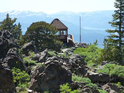
During early July this year, some trail sections near Martis Peak were still hidden under piles of snow. We met some bikers who gave up at the final section. After skirting a meadow with southwest views of Lake Tahoe and the Sierra Nevada, the TRT merges with a dirt road. While the TRT continues to the east, the trail to Martis Peak continues westward on this road (for a short distance) and then north on a paved road (16N92B), currently blocked by a fallen tree (see picture), which hikers easily bypass. After about half a mile, the wooden fire lookout building (restored through the cooperative efforts of USFS, CDF and the community) is coming into view. Assuming no fires and good weather conditions, the lookout panorama includes Mt. Rose, Mt. Verdi, the Boca and Stampede Reservoirs, Donner Lake and Pass, the mountain ranges of the Granite and Desolation Wilderness and Lake Tahoe.   

Getting to the TRT parking area at Brockway Summit
From Interstate 80, take Highway 267 south to Kings Beach. Drive through eastern parts of Truckee, pass the airport (to your left) and the Martis Creek Wildlife Area (to your right). After passing the Northstar and Ritz-Carlton turnoffs to your right, you get to Brockway Summit. The TRT crosses Highway 267 a little further downhill, where roadside parking is available.


References
[1] Tim Hauserman: The Tahoe Rim Trail. Wilderness Press, Berkeley, California, 5th printing March 2004; page 104.
[2] Mike White: Afoot & Afield • Reno-Tahoe • A comprehensive hiking guide. Wilderness Press, Berkeley, California, 2nd printing November 2008; pages 105 and 106.
[3] Martis Peak: www.summitpost.org/martis-peak/153510.

Wednesday, July 6, 2011

A blue-belly's blue belly


The western fence lizard (Sceloporus occidentalis) lives in almost every part of California and Nevada and in certain areas of the neighboring states. Males show bright blue patches or lines along the sides of the body [1-3], which are best seen when the lizard turns around—what he never does. While I was watching a western fence lizard in the upper Hunter Creek area west of Reno in Nevada, a friendly hiker came along, carefully picked up the lizard and turned him around: the above picture shows the blue belly and his yellow-orange limbs. The picture below shows the typical angle of view, which we have, when encountering lizards. The skin with coarse, spiny scales of this male lizard, exhibiting patterns of light and dark brown triangular polyominoes on a grayish white background, can be seen.


The western fence lizard is normally not found in the desert, maybe in desert canyons. Its preferred habitats include the ground, rocks and lower parts of coastal sage brush, chaparral and woodlands—from the Pacific coast (a disjunct population occurs on Isla de Cedros off of  Baja California [2]) to high elevations below 9,000 feet like the Lake Tahoe area. Its diet includes spiders, scorpions, centipedes and insects such as caterpilllars, beetles, ticks, crickets, flies and ants as well as, but rarely, other lizards [4]. My favorite part about their feeding behavior is the tick diet, which reduces our risk of getting Lyme disease: ticks in regions inhabited by the western fence lizards carry Lyme disease 45 percent less frequently than ticks in other regions [5].

References and more to explore
[1]  San Diego Natural History Museum: Sceloporus occidentalis, Western Fence Lizard [www.sdnhm.org/fieldguide/herps/scel-occ.html].
[2] I. Lindsey: Western Fence Lizard, Sceloporus occidentalis [kaweahoaks.com/html/lizard_western_fence.htm].
[3] Peter Alden and Fred Heath: Field Guide to California. National Audubon Society, Chanticleer Press, 1998; page 257. 
[4] Mary Sharp: Western Fence Lizard's Diet [www.ehow.com/about_6569760_western-fence-lizard_s-diet.html]. 
[5] Laura Hautala: Watching for Blue Bellies. Bay Nature June 2008 [baynature.org/articles/web-only-articles/watching-for-blue-bellies].

Tuesday, July 5, 2011

The Red House in Franktown Creek


The Red House is located in the Carson Range in Nevada, where the flume crosses Franktown Creek [1]: mountain bikers typically climb up to the Red House and the various trails in that area from the west side (Lake Tahoe), avoiding the steepness of the east-side trails from Washoe Valley and Carson City. But they enjoy the effortless downhill ride on that side. While I was hiking up from the the Lakeview Gate Trailhead at the end of Hobart Road, I met quite a few bikers taking that direction.

Although the house is showing some fading red color, its name reportedly derives—according to an interpreted panel in the front yard—from the name of Harry “Red” McGovern, who was a caretaker here. The house was one of the many caretaker stations along the water routes, which the Virginia and Gold Hill Water Company (VGHWC) built during the time of the booming, strongly water-dependent mining business. The VGHWC also established phone lines in 1877, operational until 1957, and at the Red House Station one can see remnants of Jeffrey pine telephone poles, wire, ceramic and glass insulators. A 1924 Dodge Roadster continues to rust in the front yard. The picnic table next to the interpreted panel is a more recent addition. The Red House property was acquired by Nevada State Parks in 1963.

Getting to the Red House
From the the Lakeview Gate Trailhead in northwest Carson City, follow the trail to the “Ghost of a Sawmill” and to Hobart Reservoir. From Hobart Reservoir, continue the downhill path through Franktown Creek for about one mile, past the Red House Dam, until you see the Red House across the creek to your left. The one-way distance between the Lakeview Gate and the gate-free house is approximately 6.5 miles, including an elevation change of almost 2500 feet.  

Reference for cyclists
[1] ScottyS: Red House Flume Trail [www.mbpost.com/trail/263841/red-house-flume-trail.html].

Sunday, July 3, 2011

Hobart Reservoir in the Carson Range

The Hobart Reservoir is located in the Lake Tahoe Nevada State Park between Carson City and Marlette Lake. This is a fishing lake (rainbow, brook, and cutthroat trout) at an elevation of 7,650 feet in the Carson Range [1]. A camp ground and scenic picnic spots are found next to it. Mike White notes that Carson City still uses water from Hobart Reservoir as part of the municipal water supply [2].

The Hobart Reservoir holds water back from running down Franktown Creek. Originally, this reservoir was part of the water infrastructure for the mining operations in Virginia City and Gold Hill. According to information given on an interpreted panel at the Red House, further down the creek, the Hobart Dam collapsed twice: on February 13, 1911, caused by ice, and again in 1955 by a not mentioned cause.  

Getting there
There are various options to hike or bike to the Hobart Reservoir, for example, from the Lakeview Gate Trailhead at the end of Hobart Road in northwest Carson City. Just follow the trail to the “Ghost of the Sawmill” and continue on for about 1.5 miles. I have met families with little children climbing up and down to the reservoir so they can enjoy floating and swimming on a water surface surrounded by mountainous scenery.  Mountain bikers may get to Hobart Reservoir by starting from places in the Lake Tahoe area such as Incline Village and Spooner Lake.

References
[1]  Hobart Reservoir: www.ndow.org/fish/where/waters/west/2009/14_hobart_reservoir_2009.pdf.
[2] “Hobart Road to Hobart Reservoir” on pages 271 to 273 in Mike White's hiking guide Afoot & Afield • Reno-Tahoe • A comprehensive hiking guide. Wilderness Press, Berkeley, California, 2nd printing November 2008.

Saturday, July 2, 2011

“Ghost of a Sawmill” next to the trail from Hobart Road to Hobart Reservoir

What looks like a failed construction of an early submarine placed in a pine and fir forest, is called “Ghost of a Sawmill.”  This over-hundred-years-old, ghosty and rusted metal multitube is a leftover of the mining and sawmilling past between Virginia City and Lake Tahoe, when the Carson Range was an “industrial zone” with operating lumber and water businesses, supplying the booming mining industry.

This is the “ghost” of a steam boiler. Between the late 1870s and 1880s this site was operated by a Sierra Nevada Wood and Lumber Company, as an interpreted panel explains. Some industrial tools and other artifacts can still be found around the steam boiler. But their is more speculation than knowledge (documented facts) circulating around on what then was happening at this place. The panel offers this:

Before the turn of the 20th century, these hills and valleys were dotted with sawmills, all frantically turning the great Sierran forests into timbers for Virginia City Mines, lumber for buildings throughout the valleys below, and cord-wood for fueling extensive steam engine operations. This lumber business was paralleled by an equally booming water-supply business; in fact, because the water companies needed lumber for their flumes—and sawmills needed water to run boilers (similar to this boiler in front of you) and transport logs—these companies often had an overlapping board of directors.

At least that sounds familiar.

Getting to the “Ghost of a Sawmill” site
Exit HWY 395 between Carson City and Reno at East Lake Boulevard at the southwest corner of Washoe Lake. Continue south on 428, parallel to the highway and turn right into Lakeview Road. Immediately, leave this road and take Hobart Road (right turn, but not much of a turn) in westward direction. After passing the intersection with Numaga Pass Road, park near the Lakeview Gate Trailhead at the end of Hobart Road.
The trail is a dirt road used by hikers and bikers. Various parts are steep. The trail over the south-side slopes of Mc Ewen Creek Canyon offer vistas of Washoe Valley and Lake. The vegetation changes from riparian to manzanitian. Higher up you'll reach open forest. When arriving at a solar-panel equipped water tank facility, the final stretch will be climb-free, again with valley and lake views and Slide Mountain to the north. After about 3.5 miles from the trailhead gate, you' ll reach another gate with a sign indicating that you are entering Lake Tahoe Nevada State Park and you are 1.5 miles away from the Hobart Reservoir (Fishing Lake and Campground) and 2.5 miles away from the Red House historical site. Never mind the sign, you have arrived at your destination: you'll see the steam boiler to your left as soon as you pass the trail that branches to the right.