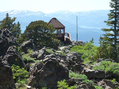
 During early July this year, some trail sections near Martis Peak were still hidden under piles of snow. We met some bikers who gave up at the final section. After skirting a meadow with southwest views of Lake Tahoe and the Sierra Nevada, the TRT merges with a dirt road. While the TRT continues to the east, the trail to Martis Peak continues westward on this road (for a short distance) and then north on a paved road (16N92B), currently blocked by a fallen tree (see picture), which hikers easily bypass. After about half a mile, the wooden fire lookout building (restored through the cooperative efforts of USFS, CDF and the community) is coming into view. Assuming no fires and good weather conditions, the lookout panorama includes Mt. Rose, Mt. Verdi, the Boca and Stampede Reservoirs, Donner Lake and Pass, the mountain ranges of the Granite and Desolation Wilderness and Lake Tahoe.
 Getting to the TRT parking area at Brockway Summit
From Interstate 80, take Highway 267 south to Kings Beach. Drive through eastern parts of Truckee, pass the airport (to your left) and the Martis Creek Wildlife Area (to your right). After passing the Northstar and Ritz-Carlton turnoffs to your right, you get to Brockway Summit. The TRT crosses Highway 267 a little further downhill, where roadside parking is available.
References
[1] Tim Hauserman: The Tahoe Rim Trail. Wilderness Press, Berkeley, California, 5th printing March 2004; page 104.
[2] Mike White: Afoot & Afield • Reno-Tahoe • A comprehensive hiking guide. Wilderness Press, Berkeley, California, 2nd printing November 2008; pages 105 and 106.
[3] Martis Peak: www.summitpost.org/martis-peak/153510.


No comments:
Post a Comment