Saturday, January 27, 2018

Take a walk through the Cypress Tree Tunnel at Point Reyes and explore the “wireless giant of the Pacific”

Cypress Tree Tunnel to KPH Station

Ornamental work at KPH entrance
Looking for Monterey cypress trees north of the Monterey peninsula? What about the Point Reyes peninsula north of San Francisco? There you can find weatherproof cypress trees branching out next to the trail leading to the lighthouse. And just off the Sir Francis Drake Boulevard—between Inverness and the lighthouse headlands—is the “tunnel” of giant Monterey cypress trees. This is the driveway to a historic wireless telegraph station—the civilian RCA/Marconi Station, also named KPH Maritime Receiving Station [1-3].


Everything intact? The KPH backside (November 2017)

As Morse code messaging declined and new technologies advanced, the station was retired in the late 1990s. It is currently preserved and cared for by the National Park Service and volunteers from the Maritime Radio Historical Society. A flyer posted onto the station's front door summarizes the history of and the current activities at the KPH station:

KPH began providing telegram service to ships at sea in 1905 from the Palace Hotel in San Francisco (thus the PH in the call sign). It continued that service until operations ended at this location on 30 June 1997.

There were hundreds of stations like KPH around the world. KPH was one of the biggest, called by some the “wireless giant of the Pacific.” One by one the lights went out at these stations. Bulldozers were waiting to demolish the buildings and antennas and build condominiums and golf courses. But KPH remained intact.

In 1999 the Maritime Radio Historical Society, in cooperation with the Point Reyes National Seashore, began a project to restore KPH to operation - the first and only a coast station left for dead has been returned to life.

Today KPH is on the air every Saturday from 12:00pm to 4:00pm. Please join us to see the only remaining civilian coast station in the world in full operation.

For more information call 414-990-7090 or send an email to: kph@radiomarine.org.


Getting there

From Olema or the Bear Valley Visitor Center, follow the direction given to get to the lighthouse trailhead. Halfway between Inverness and the end of Sir Francis Drake Blvd.—past G Ranch—look out for the sign reading “North District Operations Center - Historic RCA Building Established Circa 1929.” Find parking. The Cypress Tunnel is on the right side of the road.


References and more to explore

[1] JoshMc: Cypress Tree Tunnel in Point Reyes National Seashore.  “California through my Lens” blog post: californiathroughmylens.com/cypress-tree-tunnel.
[2] National Park Service: Historic KPH Maritime Radio Receiving Station and Cypress Tree Tunnel. Web-page: www.nps.gov/pore/planyourvisit/kph_treetunnel.htm.
[3] Roadside America: Cypress Tree Tunnel. Web-page: www.roadsideamerica.com/story/55705.

Friday, December 29, 2017

Point Reyes Lighthouse Trail

Point Reyes Lighthouse
The Point Reyes Lighthouse stands on a small platform on top of windblown rocks. Expect salt-spray and fog. In this harsh environment only specialized plant species survive. An interpretive panel tells us:
The wife of a lighthouse keeper once planted a small garden nearby, but with no success. As soon as the carrots sprouted the wind blew them away. Few plants can face up to the ocean's harsh influences.

On a foggy morning, your approach to the Lighthouse Visitor Center may include a short walk under water-dripping cypresses.

Fern plants growing on branches of wet cypresses alongside lighthouse trail

On an outside wall at the visitor center, you will find an offshore map showing the undersea topography of the continental shelf with Cordell Bank, Rittenburg Bank and Noonday Rock.

Discover an Oceanscape Under the Sea
Undersea map with continental shelf and Cordell Bank: Discover an Oceanscape Under the Sea

Skull of a gray whale
On their spring migration, California gray whales (Eschrichtius robustus) pass Point Reyes close to shore and—when the fog lifts—you can see spouting whales breaking through the ocean surface over the shelfscape. The skull of a female gray whale, found in February 1985, is on display next to the Point Reyes Conglomerate peak.

Steps alongside conglomerate
After passing the conglomerate outcrop,  you will find yourself on top of the stairway with 300-plus steps. The stairway sometimes is closed when winds are getting too strong to descend/ascend safely. Gusts exceeding 100 mph have been recorded. A panel summarizes the lighthouse history:

Point Reyes Light has guided and cautioned mariners along this hazardous coast for over 100 years. Built by the U.S. Lighthouse Service in 1870, it came under management of the U.S. Coast Guard in 1939. Resident personnel operated the station until 1975 when the conversion to automated lights and electronic equipment was completed.

The National Park Service maintains a very detailed Visit the Point Reyes Lighthouse site, which further highlights the lighthouse history and links to information on accessibility and road-closure/shuttle-bus policies during whale-watching season.


Getting to the lighthouse trailhead

From Olema or the Bear Valley Visitor Center, drive north on Bear Valley Road and turn left at its junction with Sir Francis Drake Boulevard. Follow Sir Francis Drake Blvd. for about 20 miles to its end—first northwest along the western shore of Tomales Bay to Inverness, then westward over the Inverness Ridge and finally southwest through the Pastoral Lands.


Don't miss Chimney Rock!

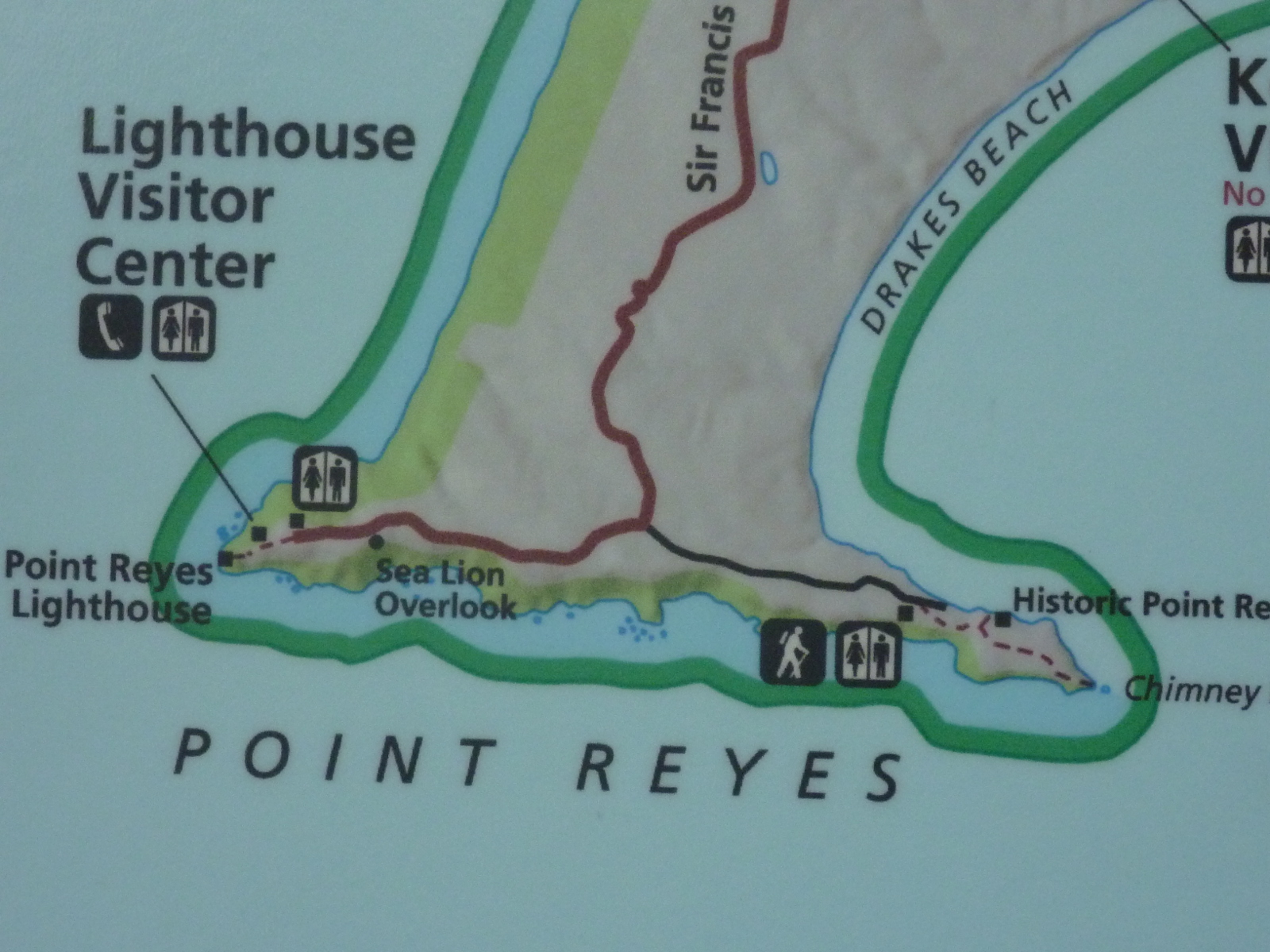
Returning from your lighthouse visit, you may want to explore the east-side spur of the headlands by hiking through grassland, enjoying views of Drakes Bay and overlooking surf-zone rocks such as Chimney Rock and the natural bridge at the end of Chimney Rock Trail. To do that, turn right on Chimney Rock Road (before passing again through the “A” Ranch). Find the parking lot and trailhead after about one mile from the Sir Francis Drake Blvd./Chimney Rock Rd. junction.


California Coast: Point Reyes headlands map with lighthouse tip and Chimney Rock tip

See more: Point Reyes National Seashore, California.

Thursday, December 28, 2017

Point Reyes Conglomerate

Outcrop of Point Reyes Conglomerate
Point Reyes Conglomerate is exposed on the Point Reyes peninsula. It can be found at the end of the Chimney Rock Trail around the overlook of Chimney Rock and the cliff arch. Next to the Lighthouse Visitor Center—at the other tip of the ocean-surrounded headlands—the conglomerate formation is exposed next to the lighthouse trail (shown above and below). There, on a display panel, and also on a web page it has been described with the following words [1,2]: 

The intriguing rock exposure in front of you is part of a formation that caps the highest hills in this area. The Point Reyes Conglomerate is a formation consisting of a sandy matrix embedded with pebbles, cobblestones, and boulders. Geologists estimate that the formation may be over 50 million years old.

Using less formal terminology, the conglomerate has been described as geologic cookie batter [3].


Features of exposed sandstone and Point Reyes Conglomerate

Watch out for similar conglomerate outcrops and sandstone features while taking a rest on your way down to or up from the lighthouse plateau.


 Lighthouse plateau downstairs

References  and related posts
[1] Point Reyes Lighthouse: www.ptreyes.org/activities/point-reyes-lighthouse.
[2] Point Reyes Conglomerate: www.ucmp.berkeley.edu/education/dynamic/session6/sess6_sign.htm.
[3]  Lighthouse, Point Reyes National Seashore, National Park Service, Marin Count: bahiker.com/northbayhikes/prlighthouse.html.

Chimney Rock Trail

Map of the Point Reyes headlands with Drakes Bay and Chimney Rock 
Chimney Rock Trail is a short Point Reyes headlands trail between Drakes Bay and the Pacific Ocean around the Farallon Islands. As you can see on the map above, several rocks and sea stacks dot the south-side coast of the eastern spur of the headlands. Chimney Rock is one of them. To get to the overlook, from where you can see Chimney Rock and the nearby natural bridge, follow the well-marked path from the trailhead (red arrow) to the end of Chimney Rock Trail.

Chimney Rock and cliff arch
Chimney Rock and natural bridge (cliff arch)

Point Reyes Lifeboat Station
Historic Lifeboat Station (Drakes Bay)
Several social trails lead close to the edges of steep cliffs of mostly Point Reyes Conglomerate, which frequently crumble and slide. Keep a safe distance! On your return walk, you may want to take Underhill Trail to get a close-up view of the historic lifeboat station, constructed in 1927. An interpretive panel at the trailhead “introduces” one of the U.S. Coast Guard crews commissioned to save ships and lives:

These seemingly ordinary men were the heroes of this coast. Like the men who served before and those who served after them, surfmen risked their lives to save mariners in distress. They were always on duty, always prepared and always willing to sacrifice.
Members of a coast guard crew
Surfmen prepared to save mariners in distress
On your final steps back to the parking lot, you will pass through a residence. You will find a plaque in the wall at the property's south entrance commemorating Francis Drake—an earlier “hero of this coast”—who landed on these shores on June 17, 1579 and took possession of the country, calling it Nova Albion.

How did these shores look then? Were the natural bridge and Chimney Rock already pounded by waves and what were their shapes?

Getting to the Chimney Rock Trailhead

From Olema or the Bear Valley Visitor Center, drive north on Bear Valley Road and turn left at its junction with Sir Francis Drake Boulevard. Follow Sir Francis Drake Blvd. for almost 20 miles and turn left on Chimney Rock Road after passing through the “A” Ranch. Find the parking lot and trailhead after about one mile at the end of this narrow two-way road.

If you are on your way back from a Point Reyes Lighthouse visit, turn right at the Sir Francis Drake Blvd./Chimney Rock Rd. junction before getting to the “A” Ranch.

Eastern spur of the Point Reyes headlands with Drakes Bay on the right side
 
Keywords: Point Reyes coast, steep cliffs, heavy surf, sea stacks, historic site, surfmen, coast guard.

Thursday, November 16, 2017

The “outer loops” in Sycamore Grove Park

Horses off Harrier Trail in Sycamore Grove Park
The outer loop trails in Sycamore Grove Park include Valley View Loop, Cattail Pond Loop, Meadowlark Loop and Harrier Trail. Whereas the inner loop trail—the Winery Loopleads around flat grasslands and orchards, the outer loop trails traverse mostly open hillsides with various vista points.

You can access those loops via Wagon Road Trail. Ascend the less steep branch of the Wagon Road Trail loop near the junction of the Winery Loop and Walnut Trail. This shaded, east-heading incline takes you above the Olivina winery ruins with views of the partially overgrown rubble inside the buildings that once were used to produce olive oil, wine and brandy.

Pair of palms near Wagon Road Trail/Valley View Loop intersection

Harrier Trail post
Post at Valley View Loop/Harrier Trail junction
Continuing south on Wagon Road Trail, you will pass another historic site, a pair of palm trees and then meet the Valley View Loop. Turn left on the loop trail and after half a mile you will arrive at the Harrier Trail post. Harrier Trail is a path traversing meadows next to an olive orchard and the Veterans Administration Hospital. The Harrier Trail incline past the row of tall eucalyptus trees alongside the hospital property leads to an unnamed loop. Either way you eventually will end up on Valley View Loop again.

The Valley View Loop summit features an excellent vista point with views of the Livermore area and Mt. Diablo farther north. Back on Wagon Road Trail, go west to Cattail Pond. You may see western pond turtles on the tiny rafts floating in the pond.

If not yet loop-tired, you still have the Cattail Pond Loop and Meadowlark Loop ahead of you, but they can be skipped by just taking the Wagon Road Trail back and downhill to the “lowlands” of the Arroyo del Valle.

Olive orchard, Livermore and Mt. Diablo (zoom in) seen from Valley View Loop Trail


Wednesday, November 15, 2017

Winery Loop Trail

The Winery Loop Trail is a 2.7-mile-long hiking and biking loop around the grasslands south of Arroyo del Valle in Sycamore Grove Park, five miles south of downtown Livermore in California. Trail highlights are the ruins of the historic Olivina Winery and the sycamore with a hole—the Hobbit Tree.

About a quarter mile south of the parks's Wetmore Road entrance, the trail follows a vineyard fence for another quarter mile to its junction with the 0.3-mile-long Olivina Trail. While you continue on the Winery Loop, you will soon arrive at an intersection, from where the 1.5-mile-long Wagon Road Trail ascends the hillscape and the 0.2-mile-long Walnut Trail offers a shortcut back to the streambed and Wetmore entrance. Past the intersection, the loop trail skirts the fenced ruins of the Olivina distillery and winery.

Ruins of the historic Olivina Winery
As you come to the junction with Kingfisher Crossing, you get another chance to shortcut the loop. If you do the complete loop, you will now travel between orchards: an olive orchard to your right (not part of the park) and a neglected almond orchard at the turning point of the loop. Here, the Winery Loop Trail meets the 2.5-mile-long Arroyo del Valle Regional Trail, which connects the Wetmore Road entrance with the Arroyo Road entrance

Old almond orchard with Wine Loop Trail

Saturday, November 11, 2017

The Hobbit Tree in Sycamore Grove Park

“Teapot view” of Hobbit Tree
The Hobbit Tree is an old sycamore tree in Livermore's Sycamore Grove Park.You can get to the tree by walking for about half a mile from the park's Wetmore Road Entrance on Arroyo del Valle Regional Trail to the trail's junction with Olivina Trail. The Hobbit Tree stands between the trail and the streambed. The site includes two benches.

Doorway and hole of Hobbit Tree
The hollowed-out sycamore houses various creatures. Hobbit-size humans find it easy to walk inside the tree through a narrow doorway or slide down to there through the oval hole. I found myself tall enough to simply look through the hole. Doing this from the Arroyo del Valle side, I got a peekhole view of the grasslands and the hills that backdrop the Olivina Winery ruins—historic structures, but younger than the Hobbit Tree. 

In a recent Bay Nature article, Sylvia V. Linsteadt shares her Hobbit Tree knowledge and discoveries:

I stopped on the Olivina Trail to visit an old sycamore known to park personnel and visitors as “the hobbit tree.” It's not hard to see why—from the outside, the tree resembles a fantastical teapot with a window, and what's more, it's partially hollow, with an arching doorway that opens into the tree's interior. Someone placed a stump just inside, and I sat there for a long time, looking up into the sycamore's hollow trunk, into darkness, trying to imagine the life of such a tree, roots down in the alluvial gravel of the old Arroyo del Valle, tall branches clattering in the breeze and home to countless birds, insects, and mammals. 


Reference and more about Sycamore Grove Park

Sylvia V. Linsteadt: Western sycamores speak of an older California. Bay Nature Oct. - Dec. 2017, 16-20+52.  Link: baynature.org/article/western-sycamores-speak-older-california.