Tuesday, December 4, 2012

Charity Valley Trail crossing Grover Hot Springs State Park


The Charity Valley Trail east of Markleeville in Alpine County, California, connects the meadows and campground around the Grover Hot Springs with the Blue Lakes Road trailhead in the Charity Valley (west-end Charity Valley trailhead). The east-end Charity Valley Trailhead is also named Burnside Lake Trailhead, since a trail that branches off Charity Valley Trail leads to Burnside Lake. The trailhead board gives the following distances: Charity Valley 4.5, west-end Charity Valley trailhead 7.5 and Burnside Lake 6.5 miles. Grover Hot Springs State Park's campground is only a half-mile away from the trailhead. Skirting the campground, you will, after 1.3 miles from start, get to a junction, at which you have the option to leave the Charity Valley Trail and head for a waterfall—1.2 miles southwest from this junction. Continuing uphill on Charity Valley Trail for another 2.2 miles, you'll reach the junction from where you may either continue to Charity Valley (3 miles) and to Blue Lakes Road (4 miles) or, switchbacking further uphill, to Burnside Lake and Burnside Lake Road (2 miles).

The eastern sections of the Charity Valley Trail are mainly going along a south-facing, granite-boulder-studded canyon slope (top picture) and parallel to Hot Springs Creek, which flows downhill through Humboldt-Toiyabe National Forest land and Grover Hot Springs State Park towards the Carson River. The western trail sections follow the canyon of Charity Valley Creek. Hot Springs Creek is flanked by forest of pines, firs and cedars. Depending on the season, you will observe interesting plants, mushrooms and animals. The picture above shows a mistletoe hanging down from a vertical branch of a juniper tree. The busy woodpecker, photographed in early November of this year, knew where to peck—and finally was rewarded with a big worm hidden within the bark of the conifer tree.

Getting to the east-end Charity Valley trailhead
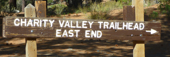
The east-end trailhead is located about three miles west of Markleeville. From Highway 89 in Markleeville, drive west on Hot Springs Road. After about one mile, pass the Pleasant Valley Road junction, from where you can get to the Thornburg Canyon trailhead. Continue on Hot Springs Road for another two miles until you approach the well-signed trailhead. Find parking on unpaved ground to the right.  


Monday, November 5, 2012

Lake Tahoe's Rubicon Trail


The Rubicon Trail along the shores of Lake Tahoe's southwest corner connects Vikingsholm Mansion at the head of Emerald Bay with attractions in D. L. Bliss State Park such as Rubicon Point's Lighthouse and the Balancing Rock. The two-mile trail section along the Emerald Bay shore between the Vikingsholm grounds and Emerald Point offers various views of Fannette Island—the focal point from about any place in and above the bay.

Fannette Island in Emerald Bay


From Emerald Point, Rubicon trail winds and climbs northward passing large boulders, cozy coves and tiny beaches. Multiple vista point invite for short breaks and magnificent views. Certain points allow a direct view down into the deep blue, leaving it to your imagination to further dive down into the submerged West Tahoe Fault (WTF). Earthquakes have occurred in this area in prehistoric time. They will happen again. Certain sections of the Rubicon Trail are probably high enough to be considered as a tsunami escape route; although falling trees, falling rocks and landslides are other possible threats. Indeed, the southwest corner of Lake Tahoe is an exciting place, staging both drama and serenity. 

Getting to the Rubicon Trailhead in Emerald Bay State Park
There are fee-based and no-fee parking areas available along Highway 89 (Emerald Bay Road) above Emerald Bay. The parking fee for the Vikingsholm parking lot on the eastside of the highway is currently $10.00 (see http://www.vikingsholm.org/tours.html). But arriving during the right time, early or off-season, you may find free parking on the westside between the Vikingsholm and Eagle Falls parking areas. From there, carefully cross the highway and take the short trail next to the highway to access the Vikingsholm parking lot, from where a steep, well-maintained trail leads down to the Rubicon Trailhead and Vikingsholm Castle.   

Note: There is a loading/unloading dock for private boats. This dock is located close to the Rubicon Trailhead at the Vikingsholm beach. Unfortunately, tour boats do not provide disembarking services in Emerald Bay. However, non-motorized Tahoe visitors have a chance to get to the bay by bus from both North Shore and South Shore locations. 

Thursday, November 1, 2012

The next long trail: Carson Valley Discovery Trail in the Pine Nut Mountains

The Pine Nut Mountains stretch for almost forty miles north-south from Dayton in northwestern Nevada to Topaz Lake at the Nevada-California stateline [1]. This mountain range with peaks as high as 7,300 feet is located east of the Sierra Nevada, bounded on its west side by the Carson Valley and on its east by the Mason Valley.

A new 45-mile-long, non-motorized, recreational trail, which will include five loop trails, is proposed along the westside of the Pine Nut Mountains: Carson Valley Discovery Trail. The Carson City Sierra Front Field Office of the Bureau of Land Management (BLM) is coordinating environmental and national historic preservation assessments in order to begin with the trail construction [2-4]. On November 14, from 5 to 7 pm, a public workshop for community input is scheduled at Pinon Hills Elementary School, 1479 Stephanie Way, Minden [4].

Keywords: trail planning, trail construction, trail network, hiking, outdoors.

References and more to explore
[1] SummitPost: Pine Nut Mountains - Nevada [www.summitpost.org/pine-nut-mountains-nevada/623219].
[2] BLM News Release, Carson City District: BLM Seeks Input on the Proposed Carson Valley Discovery Trail. October 25, 2012 [www.blm.gov/nv/st/en/info/newsroom/2012/october/blm_seeks_input_on.html].
[3] U.S. Department of the Interior: Carson Valley Discovery Trail, Public Scoping. October 31, 2012 [www.carsonvalleytrails.org/docs/EastCarsonValley/ECVTS_ScopingInfo.pdf].
[4] Reno Gazette-Journal, Outdoors Briefs: BLM seeks input on Carson Valley Discovery Trail. November 1, 2012; 3C [www.rgj.com/article/20121101/LIV08/311010041/BLM-seeks-input-Carson-Valley-Discovery-Trail].

Tuesday, October 30, 2012

Lola Montez Lake Trail


Lola Montez Lake Trail is a hiking and mountain biking trail, which connects its trailhead next to the fire station at the Soda Springs exit of Interstate 80 between Sacramento and Truckee with the Lower and Upper Lola Montez Lakes—and also with the Hole in the Ground trail. Since there are two lakes, both named for the legendary gold-rush actress and dancer Lola Montez, the trail name also occurs in plural form: Lola Montez Lakes Trail, as the trailhead sign on the page Lower Lola Montez Lake, Sierra Nevada, California shows (see paragraph Getting to Lola Montez Lakes Trailhead).

The new signpost shown above is located about half a mile from the trailhead, where the beginning single-track trail meets a gravel road. This road descends to Lower Castle Creek. A short distance past the creek crossing, another single-track section ascends from a marked junction to the next gravel-road section. Following this road, which passes by private property and no-trespassing signs, will take you into Tahoe National Forest territory and therein to a junction, at which the Hole in the Ground Trail branches off to the right, connecting Lola Montez Lakes with the Pacific Crest Trail (PCT). A short westbound walk from the junction, Lower Lola Montez Lake comes into view. The upper lake can be reached via the single-track trail along the northwest shore, from where one needs to climb and cross the granite landscape seen in the back of the picture.  

Tuesday, October 16, 2012

Out of the Truckee River Canyon to the TRT and Painted Rock area


The Truckee River Canyon between Truckee and Tahoe City features a string of camp grounds and picnic areas. Various biking and hiking trails can be accessed from within the canyon. Other trails, such as the Sawtooth Trail, skirt the canyon and provide scenic vista points. Most prominent, the Western States Trail, which in major sections coincidences with the nation's first non-motorized, coast-to-coast American Discovery Trail (ADT) [1], crosses the canyon.

The Painted Rock area along the Tahoe Rim Trail (TRT) is only a few miles away from where the Western State Trail crosses the Truckee River. Hikers, mountain bikers and horseback riders have the option of a moderate out-and-back trip to the Painted Rock(s) or a longer loop-including round trip, which has recently been described in a detailed, GPS-tracked trailhiker post [2]. Interestingly, it is not clear where, exactly, the Painted Rock is to be found. In my opinion, there are many painted rocks— assuming that the term painted rock refers to a rock with lichen- and erosion-based coloring and shading. The top picture with brain-like rock structures are located next to the TRT junction, while the others are found further to the east along the Watson-Lake-bound TRT.

Getting to the Western States Trail crossing and the TRT
The Western States Trails crosses the Truckee River on a Highway 89 bridge half-way between the Squaw Valley and the Alpine Meadows turnoffs. Driving south, you may find right-side shoulder parking before or after this bridge, overpassing the Truckee river and bike trail. Parking space is very limited. Just before driving onto the bridge, you'll see the Western States Trail signpost to your right. From the south end of the bridge, the Truckee Bike Trail can be accessed. Underpass the bridge on the bike trail and immediately ascend to find yourself on the opposite side of Highway 89. Here, the eastbound Western State Trail starts as a single-track trail. The trail winds out of the canyon for about two miles through pine and fir forest. Turn left at its junction with the TRT. Good luck with the painted rocks!    
 
References and more to discover
[1] American Discovery Trail: California [www.discoverytrail.org/states/california/ca_info.html].
[2] trailhiker: Western States Trail - Painted Rock loop from CA-89 [trailhiker.wordpress.com/2012/09/18/western-states-trail-painted-rock-loop-from-ca-89/]

Monday, October 15, 2012

From Gregory Creek Trailhead to Tahoe Donner trail network


The Gregory Creek Trailhead (GCTH) is a popular gateway to the Donner Lake Rim Trail (DLRT). This trailhead is located just north of the Donner Lake exit of Interstate 80 between Donner Summit and Truckee, California. From here, Summit Lake is 3.5 miles away. About the same distance applies to the trail that connects the GCTH with its toponymic overlook and the end (or beginning) of Gregory Creek Overlook Trail. The straight distance between GCTH and Gregory Overlook at the steep southern edge of the Donner Ridge is less than a mile. You do not want to climb up directly. Instead, the trail, used by mountain bikers and hikers, follows Gregory Creek northward to the Drifter Hut plateau. It then U-turns southward and continues along the slope below Donner Ridge.

The whole trail is single-track. At the Gregory Creek Trail/DLRT junction (about one mile from GCTH), you will take the right DLRT branch—the direction given as Drifter Hut and Glacier Way on the signpost. On this DLRT section you are going to leave the riparian habitat and climb up the forested slope until you get to the outcrops shown in the picture above. A few more switchbacks and you'll reach a plateau, which belongs to a patch of the Tahoe National Forest next to the area with the Tahoe Donner trail network. Watch out for the DLRT post signaling the almost-180-degree turn. Now comes an easy-going mile with magnificent views. At the vista site (posted as Negro Canyon Overlook), DLRT currently ends; but you are at another Tahoe Donner entry point, connecting with the Glacier Way Trailhead and further ridge, overlook and loop trails—actually, well-marked fire road trails.

Wednesday, October 10, 2012

Gregory Creek Overlook Trail

Gregory Creek Overlook Trail is a short trail connecting the Glacier Way Trailhead with the Donner Lake Rim Trail (DLRT). The signpost at the end of the overlook trail, where the DLRT starts, still uses the designation Negro Canyon Overlook Trail. This seems to be politically incorrect, since the word Negro here does not present the Spanish adjective for black; but, instead, refers to a person of black ancestry or appearance. There is the possibility that the name refers to Albert Johnson, an African American and resident of Donner Lake around 1878 [1]:
Johnson was well known and respected, and was a cook at the Truckee Hotel and later worked as a cook on a Lake Tahoe steamer. [...]. Eventually, he began renting cabins at Donner Lake near the output of Gregory Creek, which flows from Negro Canyon [sic!]. Unfortunately, his name does not appear on land or property records, making it difficult to establish if he has any official connection to the Negro Canyon name.

Let's stay with the name Gregory Creek for the canyon and, as done above, with the name Gregory Creek Overlook Trail for the Tahoe-Donner fire road trail, which ends at the marker with number 22 (see map). This scenic spot offers views of the western tip of  Donner Lake, Donner Pass Road with Rainbow Bridge, Mt. Judah, Roller.Pass and other features of the Pacific Crest. From this point and during a hike along the adjacent northbound section of the DLRT one gets various views of Gregory Creek. The picture below shows the DLRT section west of the junction, at which the Wendin Way Access Trail (not seen, since at the canyon bottom), also named Gregory Creek Trail (but not Negro Canyon Trail), meets the DLRT. Obviously, the mapping of this area has experienced a history of naming confusion. Fortunately, all its trails are easy to find and also well marked, when it comes to giving directions to destinations such as Summit Lake, Drifter Hut and Glacier Way.

Keywords: (in)correct naming, toponyms, hiking, mountain biking, vista points, Donner Lake, Sierra Nevada.

Reference
[1] Truckee Open Space > Negro Canyon (Upper Gregory Creek) [www.tdlandtrust.org/truckee-open-space].