 |
| Kayakers taking advantage of the tidal inflow to explore Hatches Harbor salt marsh areas |
Herring Cove Beach and Hatches Harbor of Cape Cod's Cape Tip area can be accessed from downtown Provincetown by choosing between different routes. My favorite one includes the bicycle trails through a mixed forest and over sand dunes. The total one-way-distance is a little over five miles. It includes about one mile from downtown to the Beech Forest trailhead next to Race Point Road. Then, 2.1 miles on the forest-pond-dune section of the Province Lands Bicycle Trail loop, another one mile on a paved trail traversing the coastal sand dune landscape and finally a beach walk north to Hatches Harbor with the Race Point lighthouse in view.
 |
| A view across Hatches Harbor to the Race Point Light Historic Site |
Start this hike or bicycle trip by leaving Provincetown northbound on Conwell Street. Pass Highway 6 at the street light. For a short distance, continue north on Race Point Road until you see the trail sign and the beginning of a two-lane bicycle path on the left. Follow this path to the Province Lands Bicycle Loop in the Beech Forest area. Turn left and continue westward on the 2.1 mile-long loop section. For almost two mies you will travel through dense forests passing various fresh-water ponds. Leaving the forested area, you

 |
| Bicyclist on Herring Cove Trail |
 |
| Herring Cove sand dunes |
Once you arrive at the beach, you want to leave your bike behind (if you came with one) and stroll north along the shoreline.
 |
| Herring Cove Beach |
The area you are entering now is changing its appearance within minutes due to the tidal flow of water. The most exciting place to watch the impressive ups-and-downs of salt water is the Hatches Harbor Habitat. This salt marsh estuary has an interesting recent history [1]:
The Hatches Harbor salt marsh is a remnant of a larger salt marsh complex that existed at the time of the first European settlement. This salt marsh was primarily a Spartina patens (salt hay grass) and S. alternifolia (smooth cord grass) community. In 1930, the upper 200 acres were enclosed behind a dike in an effort to contril salt water mosquitoes. The elimination of tidal flow dewatered part of the upper marsh, changing the mosaic of salt marsh and wetland communities. Subsequently, a small airport was constructed on the landward end of the marsh, an airport which today is a vital part of Provincetown's economy.
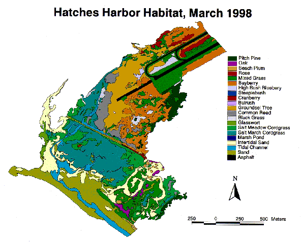
The airport can clearly be identified in the Hatches Harbor map [2]. The map also shows different zones with their predominant plant species.Thanks to tidal restoration efforts shellfish have re-colonized disturbed salt march zones, estuarine fish are again foraging in tidal creeks and important predators to mosquito larvae have returned [3].
 |
| Herring Cove Beach merging with Hatches Harbor salt marsh |
References and more to explore
[] Norm Farris: Hatches Harbor Habitat. Link: https://www.nps.gov/gis/gisday/gallery/caco/hatches.html.
[2] Hatches Harbor Habitat, March 1998. Link: https://www.nps.gov/gis/gisday/gallery/caco/hatches.gif.
[3] National Park Service, Cape Cod: Hatches Harbor Tidal Restoration Project. Link: https://www.nps.gov/caco/learn/nature/hatches-harbor-tidal-restoration-project.htm.


No comments:
Post a Comment