Saturday, May 9, 2020

Total Recall Trail: uphill with Peavine Peak in view

Peavine-Trails mountain bikers
Colorful mountain bikers on Total Recall Trail

Peavine Mountain
Peavine Peak seen from Total Recall/Stage Coach trail junction

The Total Recall Trail connects the Keystone Canyon north of Reno with the Lingles Loop area of the Peavine Trails network. This single-track hiking and mountain-biking trail begins at trail marker 60 on the Keystone Canyon Trail.

Total Recall Trail starting out of Keystone Canyon

First, it leads north-northwestward to junctions with the Stage Coach Trail and Poedunk Trail. The radio towers are always in view. Total Recall climbs up to its junction with the Halo Trail and further onto the ridge with the Rock Pile and the bench. This is the the other end of the Stage Coach Trail (trail marker 65)—obviously, you have various loop options here. This ridge-top trail junction offers scenic views of Mount Peavine. It is a meeting and socializing hot spot, currently with social distancing rules you want to keep continuing with by following the temporary Covid-19 directional trail recommendations

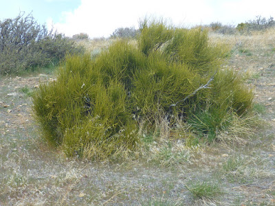
Mormon Tea
Mormon Tea brush (green ephedra) next to Total Recall Trail

After a short downhill hike or ride and a pleasant valley-meadow section, Total Recall ascends toward the Lingles Loop, Bobsled, Colpo Cyn and Scrub Brush Trail.


Dwarf onions
Dwarf onions flowering off Total Recall Trail

To get back to the Keystone Canyon, you may want to consider taking the short Over Easy Trail at the south tip of the Lingles Loop and then follow the Bacon Strip and Halo Trail downhill to the Snow Terraces, from where the Snow Terrace Snow Terraces Trail and Fisticuffs Trail leads you down into the canyon.


More about Total Recall Trail

Total Recall is a popular mountain biking trail: a 3.1-mile-point-to-point singletrack rated as intermediate with an average grade of 6% and a maximum grade of 17%.

Sunday, April 19, 2020

Switching (off) the fear factor on Peavine Trails

Currently, you will find more COVID-19 recommendation posts than rattlesnake warning signs along the Peavine Trails—a networks of hiking & mountain biking loops and trails northwest of Reno, Nevada. The recommendations have been posted to remember trail users how to manage avoiding the spread of the SARS-CoV-2 virus, a coronavirus that can cause the respiratory disease COVID-19.

Even outdoors in open space, social distancing is key. To minimize the chance that hikers, joggers and cyclist may run into each other, the temporary directional trail recommendations are set up such that many of the single-track trails are suggestively turned into one-way paths. “Direction Suggested” and  “Direction Not Suggested” signs have been posted. Either type asks people to remember the following:

Announce Yourself Early to Others

“Be Nice - Say Hi” and Smile when Passing

Move at Least 6 ft off Trail when Passing

Avoid Congregating at Intersections.

It works. There is nothing to fear and lots to enjoy. The value of a recreational trail network next to urban neighborhoods is priceless—anytime.

The posted signs you temporarily will see at many trail junctions and intersections:


COVID19 temporary trail recommendation: Suggested Direction

COVID19 temporary trail recommendation: Direction Not Suggested


Sunday, September 22, 2019

Cold Creek Trail 18E06

Cold Creek: unnamed waterfalls
Cold Creek Trail is a single-track trail leading from South Lake Tahoe, California, uphill to High Meadows. The 2.5-mile-long trail follows Cold Creek along the left (north) side. Almost level at its beginning near Powerline Trail, Cold Creek Trail continues as a sequence of switchbacks. It is popular with mountain bikers—and over certain sections quite a challenge. Hikers love this shaded creek & forest trail as well.

Cold Creek Trail near Powerline Trail
My Lake Tahoe Basin Trail Map marks Cold Creek Trail with two black diamonds—for “expert” use. Indeed, you need to master a few steep and rough rock jumps. I have seen many riders walking their bike at those locations. Half-way up you will pass by a few insignificant, yet beautiful waterfalls; where you may want to take a break and refresh. The trail mellows out as you are getting close to the meadows. Here, Cold Creek slowly meanders through brightening mixed forest.

Granodiorite rocks next to Cold Creek Trail
Cold Creek Trail ends at a creek crossing. Actually, it splits into two trails. One path continues uphill for another two miles to Monument Pass and the Tahoe Rim Trail (TRT). The other, across the creek, starts out as High Meadow Road, which you can take to get back to South Lake Tahoe and Meyers. The latter also connects with the 3.1-mile long Star Lake Trail—accessing Star Lake, the TRT and the Freel Peak surroundings within the Carson Range. 

Cold Creek at High Meadows


Friday, August 30, 2019

On and off the PCT: climbing Mount Lincoln


Pacific Crest Trail south of Mount Lincoln
Looking south from Mount Lincoln: the PCT follows the Pacific Crest toward Anderson Peak
Mount Lincoln, like Mount Judah, is an easily accessible peak in the Sierra Nevada located south of Donner Pass—west of Truckee, California. The Pacific Crest Trail (PCT) passes through between these two peaks. The gap in-between is known as Roller Pass or Judah-Lincoln Pass. Whereas Mount Judah is accessible via the popular, well-signed Mt. Judah Loop Trail, which shares a 1.1-mile-long trail section with the PCT, “Mt. Lincoln Trail” is an unsigned use trail.

A snow-covered section of the PCT near Roller Pass
Mount Lincoln's east-side slopes: sections of the PCT still snow-covered (mid-August, 2019)
From the Donner Pass, hike south on the PCT for about three miles. Once you are leaving the forest of the Roller Pass area, continue on the PCT traversing the steep eastern slope of Mt. Lincoln. Watch out for the junction, from where a narrow trail winds up to Mt. Lincoln. With the ski lift installation on the top of Mt. Lincoln always in sight, it is easy to stay on track. The panoramic view is amazing.

Pacific Crest lichen
Lichen patterns on a rock next to Mt. Lincoln Trail with Anderson Peak and Tinker Knob in the background

The winter ski area boundary on top of Mount Lincoln

Sugar Bowl in August
Sugar Bowl summer-view from Mount Lincoln with Castle Peak in the far back


Tuesday, August 20, 2019

Roller Pass—also known as Judah-Lincoln Pass


PCT at Roller Pass
If it weren't for the “Truckee Trail - Roller Pass” marker on the Pacific Crest Trail (PCT), most hikers would not notice they are passing a historical spot. The PCT—between Mt. Judah and Mt. Lincoln—is an almost level path through forest. Difficult to believe that the PCT here intersects an old wagon route.

E. W. Harris made three hikes to Roller Pass in the summer of 1977. He did review the history of emigrant parties in the Donner area and described the Roller Pass topography in detail [1].  The Roller Pass was discovered in 1846 by Joseph Aram, who was with a party of about twelve families on his way from Illinois to Santa Clara Valley [1-3]. Until then, the Donner Pass (Truckee Pass) was used to go west. Pausing at Truckee Lake (now Donner Lake), the Aram Party, guided by Chief Truckee, explored for an easier crossing of the Sierra Ridge. Referencing an article in the Journal of American History, Harris writes [1,4]:

Finally Aram turned to the southwest following Cold Creek to its confluence with Emigrant Creek and thence (presumably) to its head along Emigration Canyon. Here they reached the pass between Lincoln und Judah peaks, and found it incredibly steep for wagons, some 800 feet higher than Truckee (Donner) Pass, but in the final analysis easier for wagons.

PCT near Roller Pass with view of Mt. Lincoln
To get to “the pass between Lincoln and Judah peaks” today, follow the PCT south from the Alpine Skills Institute, 11400 Donner Pass Road, Truckee, CA 96161. It takes 1.3 miles to the first PCT/Mt. Judah Loop Trail junction and another 1.1 miles to the second junction. Continue southward on the PCT for a quarter mile and you will find yourself on Roller Pass—ready to begin your own analysis.

References and more to explore

[1] E. W. Harris: The Early Emigrant Pass between Mt. Judah and Mt. Lincoln.  In: Nevada Historical Society Quarterly, Spring 1979, Volume XXII, Number 1, pp. 31-39 . Link: epubs.nsla.nv.gov/statepubs/epubs/210777-1979-1Spring.pdf.
[2] Capt. Joseph Aram. Link: http://www.mariposaresearch.net/santaclararesearch/SCBIOS/jaram.html.
[3] Roller Pass. Donner Summit Historical Scociety. Link: http://www.donnersummithistoricalsociety.org/pages/JudahLooppgs/RollerPass.html.
[4] Joseph Aram,  “The Reminiscences of Captain Aram,” in James T. Watson, “Across the Continent in a Caravan,” Journal of American History, 1907, Vol. I., #4, 628.

Sunday, July 28, 2019

Castle Rock hiking: Saratoga Gap Trail and Ridge Trail

Vaqueros sandstone with tafoni at Castle Rock Sate Park
Castle Rock Falls
A scenic, 5-mile-long hiking trip in Castle Rock State Park, California, includes a section of the Castle Rock Trail and the full length of both the Saratoga Gap Trail and the Ridge Trail. There is an Interconnector Trail between the latter two, allowing for an overall shorter loop. You want to extend? Just add in a side loop to check out the interpretive shelter near Goat Rock. Trail highlights are the Castle Rock Falls (early spring), the “tafoni-decorated” Vaqueros sandstone sites and the never-ending views of the Santa Cruz Mountains, Big Basin and Monteray Bay.

This is a popular hiking and climbing area. As you get past the Interconnector Trail (post at its Saratoga Gap Trail junction shown on the left) into the Varian Peak area, you probably will experience less trail traffic. The waterfall and Goat Rock are the main attractors (and accessible in shorter time).

Don't miss the Patrick Charles Allen Memorial Grove of redwoods near the footbridge on Saratoga Gap Trail close to the Interconnector Trail junction. A short path leads down into a ravine with a redwood fairy ring.

As you continue on westward on Saratoga Gap Trail—now skirting Varian Peak—and leave the dense forest, the path winds through chaparral covering steep hillsides. The trail has rocky parts, under your foot (watch your steps!) and in front: you are approaching a Tafoni Cliffside. At some point you need to negotiate a narrow ledge, but a metal cable at the rock face helps you to stay on track.

Saratoga Gap Trail with tafoni cliffside in front
Back in the forest, the scenery changes from eroding sandstone to exfoliating bark: Pacific madrones are shedding their reddish-brown “skin.” 

Madrone trunk with peeling bark

Soon, you will be at the junction from where the Ridge Trails ascends towards Russell Point and continues along the ridge line toward Varian Peak and Goat Rock. There are a only a few vista points on this stretch of trail.


View from Ridge Trail: Can you trace the Saratoga Gap Trail winding through chaparral?
While Dan Seldows's Fraggle Rock Grove is a great spot to meditate in shade, the Emily Smith Observation Point and the scenic overlook near Goat Rock provide sweeping views of the San Lorenzo Headwaters Natural Preserve and beyond—one level up from the views you experienced along Saratoga Gap Trail.

At the Partridge Farm Interpretive Shelter—off the Ridge Trail near Goat Rock—you may want to rest and study the Castle Rock history. Between Goat rock and the shelter you will pass by yet another named grove: Ralph and Velma Angle Memorial Grove. I still need to find out, what this grove is about.

Partridge Farm Interpretive Shelter

The tafone of a nearby rock could also serve as a shelter. Its sandstone wall contains roughly spherical, differently colored masses, which—as I hopefully recall correctly from my geology lesson at the shelter—are termed cannonballs. At least, shape and size looks right.  


Tafone with rounded “cannonballs” in the wall

Past these outcrops, Ridge Trail descends over rocks and occasional stairs into the canyon of King Creek, where it meets Saratoga Gap Trail to close the loop. The park entrance at Skyline Blvd. is 0.2 miles away—uphill.


Getting there

From Saratoga Gap—the intersection of Hwy 35 (Skyline Blvd.) and Hwy 9—drive south on Hwy 35. The Main Park Entrance for Castle Rock State Park will come up on the right side after about two miles. The park brochure features a trail map: https://www.parks.ca.gov/pages/538/files/CastleRockSPFinalWebLayout082117.pdf.


Address

Castle Rock State Park
15000 Skyline Boulevard
Los Gatos, CA 95030


More about Castle Rock State Park

Rebecca Pratt visited Castle Rock State Park recently and hiked there with Beatrix Jiménez from Sempervirens Fund. She writes about her nature experience and reflects on the past and future of the park in the Summer 2019 issue of Bay Nature. Link: https://baynature.org/article/a-21st-century-gateway-to-castle-rock-state-park/.

Friday, June 28, 2019

Humbug Trail: hiking to a granite-slot waterfall


Humbug Falls: water coming down a granite slot, falling and shooting through carved out channels

The Humbug Trail in California's Malakoff Diggins State Historic Park connects “The Diggins” with the South Yuba Trail. Also named Humbug Creek Trail, this 2.7-mile-long single-track trail between the North Bloomfield Road and the South Yuba River roughly follows a series of shafts. These are vertical openings once used to construct a bedrock tunnel—the North Bloomfield Tunnel—to drain water and mining debris. The trailhead is near the West Point Overlook south of Diggins Lake. It is accessible by driving 1.5 miles south-southwest Trailhead from the Visitor Center and Museum in North Bloomfield, once named Humbug.


Humbug Creek
The one-way distance from the North Bloomfield Road trailhead to the waterfall is 1.25 miles—less than the half-way distance to the Yuba River. The fairly level trail, which follows the steep ravine cut out by Humbug Creek, is shaded and variously lined by poison oak. Humbug Falls are a chain of waterfalls. The most interesting sections, in my opinion, are those where the water is not falling, but shooting through channels carved out off the granite bed. 

Hikers on Humbug Trail


Also interesting to see at Malakoff Diggins:


A trail map of Malakoff Diggins State Historic Park is available with the park brochure: https://docs.google.com/viewerng/viewer?url=http://malakoffdigginsstatepark.org/wp-content/uploads/2017/09/MalakoffSHPFinalWebLayout051517.pdf&hl=en_US.