Sunday, June 11, 2023

A tune became a trail: Seven Steps Trail

Seven Steps Trail

The Seven Steps Trail is a continuation of the Vicee Canyon Rim Trail. Both trails are short single tracks—side trails to Bob's Trail—within the Ash Canyon Trail System west of Carson City, Nevada.

The 0.3-mile-short Seven Steps Trail is open to hiking, mountain biking and equestrian activities. It connects the west-side end of  the Vicee Rim Trail with Bob's Trail—the main trail thread through the trail network connecting Carson City's Foothill Drive with the Ash-to-Kings trailhead. 

From Vicee Canyon, the Seven Steps Trail travels upward across an east-facing slope with views of Carson City. The trail has some step-like features. While hiking uphill and counting, I came to the conclusion that “seven steps” is a reasonable approximation. However, according to the trail website, the trail name is attributed to the tune of jazz musician Miles Davis: “Seven Steps to Heaven” (on a record released in 1963). 

The smell of trail heaven: sweetly fragrant flowers of tobacco brush

Once you are in heaven, it just takes a few steps downhill to get back onto Bob's Trail.


Map links

Map of westside Carson City with Vicee Canyon: https://mapcarta.com/23374436/Map.

Ash Canyon Trail System map: https://www.carson.org/home/showpublisheddocument/80022/637861499835270000


References

Click the Seven Steps Trail tab on the Ash Canyon Trail System website or look for other trails within the trail network: https://www.carson.org/government/departments-g-z/parks-recreation-open-space/parks-and-places/trails/ash-canyon-area.

Seven Steps to Heaven (Wikipedia, accessed on June 11, 2023): https://en.wikipedia.org/wiki/Seven_Steps_to_Heaven.


Saturday, June 10, 2023

Vicee Canyon Rim Trail

Vicee Canyon Rim Trail with mountains of the Carson Range in the back 

Vicee Canyon Rim Trail is a 1.3-mile-long single track within the Ash Canyon Trail System west of Carson City, Nevada. Vicee Rim Trail—a shorter name for this short track—follows the south rim above Vicee Canyon. The open-space dirt trail leads through sagebrush habitat with views of the canyon and the Carson Range. 

At its west-side end, Vicee Rim Trail continues as Seven Steps Trail. Along with the latter and a section of Bob'sTrail, these single tracks form one of  many trail loops within the trail system.


Vicee Canyon seen from its south rim


Getting to the Vicee Canyon Rim Trailhead

The Vicee Canyon Rim Trail splits of Bob's trail less than half a mile northwest from the start of Bob''s Trail at the end of Foothill Drive. Foothill Drive is a short cul-de-sac next to where Carson City's West Winnie Lane bends south and continues as North Winnie Lane.

Bob's Trail/Vicee Rim Trail Y-junction


Map links

Map of westside Carson City with Vicee Canyon: https://mapcarta.com/23374436/Map.

Ash Canyon Trail System map: https://www.carson.org/home/showpublisheddocument/80022/637861499835270000


More about the trail system

Click the Vicee Rim Trail tab on the Ash Canyon Trail System website:or look other trails within the trail network: https://www.carson.org/government/departments-g-z/parks-recreation-open-space/parks-and-places/trails/ash-canyon-area.


Sunday, April 23, 2023

Jacks Valley Loop

View of Genoa Peak from Jacks Valley Loop

Jacks Valley Loop is a 6.5-mile-long loop trail in the Jacks Valley Wildlife Management Area southwest of Carson City, Nevada. The loop is part of the Clear Creek Trail System—4.7 miles of the loop is coinciding with the 21.7-mile-long Clear Creek Trail that connects James Lee Park with the Tahoe Rim Trail (TRT) at Spooner Summit.

Map of Jacks Valley Loop and access trails

Access trail from James Lee Park

As a single-track trail, Jacks Valley Loop is open to running, hiking, mountain biking and equestrian sports. The trail is open to dogs. Once on the loop, no further climbing is needed: the open-space trail winds through sagebrush habitat with amazing views of  the Carson Valley, the Carson Range and the Pinenut Mountains.

To get to the loop, follow the 0.9-mile long uphill path from the James Lee Park Trailhead to the eastside Clear Creek Trail/Jacks Valley Loop junction (CCT/JVL-east).  

CCT/JVL-east trailpost
Here, I am following the loop clockwise by starting out southbound. This sequence of switchbacks makes for over a quarter of the loop. The final switchback at the southeast tip of the loop is a great place to rest and enjoy views of the Carson Valley towards Minden/Garnerville and beyond.


Peaks of the southern Carson Range 

My favorite section of the loop is the panoramic south section. During winter and spring months, it offers vistas of the snow-covered peaks of the southern Carson Range. At mid-section, I found a small area with a scattering of low-growing yellow violets (Viola aurea), showing their bright, five-petaled flowers backdropped by white-hairy, gray-green leaves. The purple veins on the lower middle petal are arousing my curiosity at each close encounter.    

Yellow violets, south-facing slope, Jacks Valley Loop (April 23, 2023)

The shorter westside section of the loop offers views of Jacks Valley and Duane Bliss Peak. From the Clear Creek Trail/Jacks Valley Loop junction (CCT/JVL-west), Clear Creek Trail leaves the loop northwards to the Jacks Valley Road Trailhead and the Jacks Valley School Trailhead. To return to CCT/JVL-east, take the 1.8-mile-long north section of the loop to conclude your round trip.

View fromCCT/JVL-east: Carson Valley and Pinenut Mountains

Getting there

Driving south from Carson City to Minden on Highway 395, pass the Jacks Valley Road exit and then—about another mile south—turn right onto Mica Drive. Continue west for 500 ft and turn left onto Vista Grande Blvd. Follow this south-west leading road to the James Lee Park sign. Turn right onto James Lee Park Road (going westward), which soon bends south. Turn right onto James Lee Road. It ends at the trailhead. 

James Lee Park Trailhead


Nearby trails


References and more to read

Map of the Clear Creek Trail System: https://carsonvalleytrails.org/wp-content/uploads/2023/04/2023-04-18-Clear-Creek-Trail-System-Map-39x23-for-website.pdf.

Clear Creek Trail System Information. URL: https://carsonvalleytrails.org/wp-content/uploads/2023/04/2023-04-Clear-Creek-Trail-Overview.pdf.

Yellow Violet on page 37 in Laird R. Blackwell's Tahoe Wildflower Guide, Morris Book Publishing, LLC, 2007 (ISBN-13:  978-0-7627-4369-8,  ISBN-10: 0-7627-4369-7).


Sunday, November 13, 2022

Hiking the Sonoma coastline and enjoying sweeping views of sea stacks: Kortum Trail

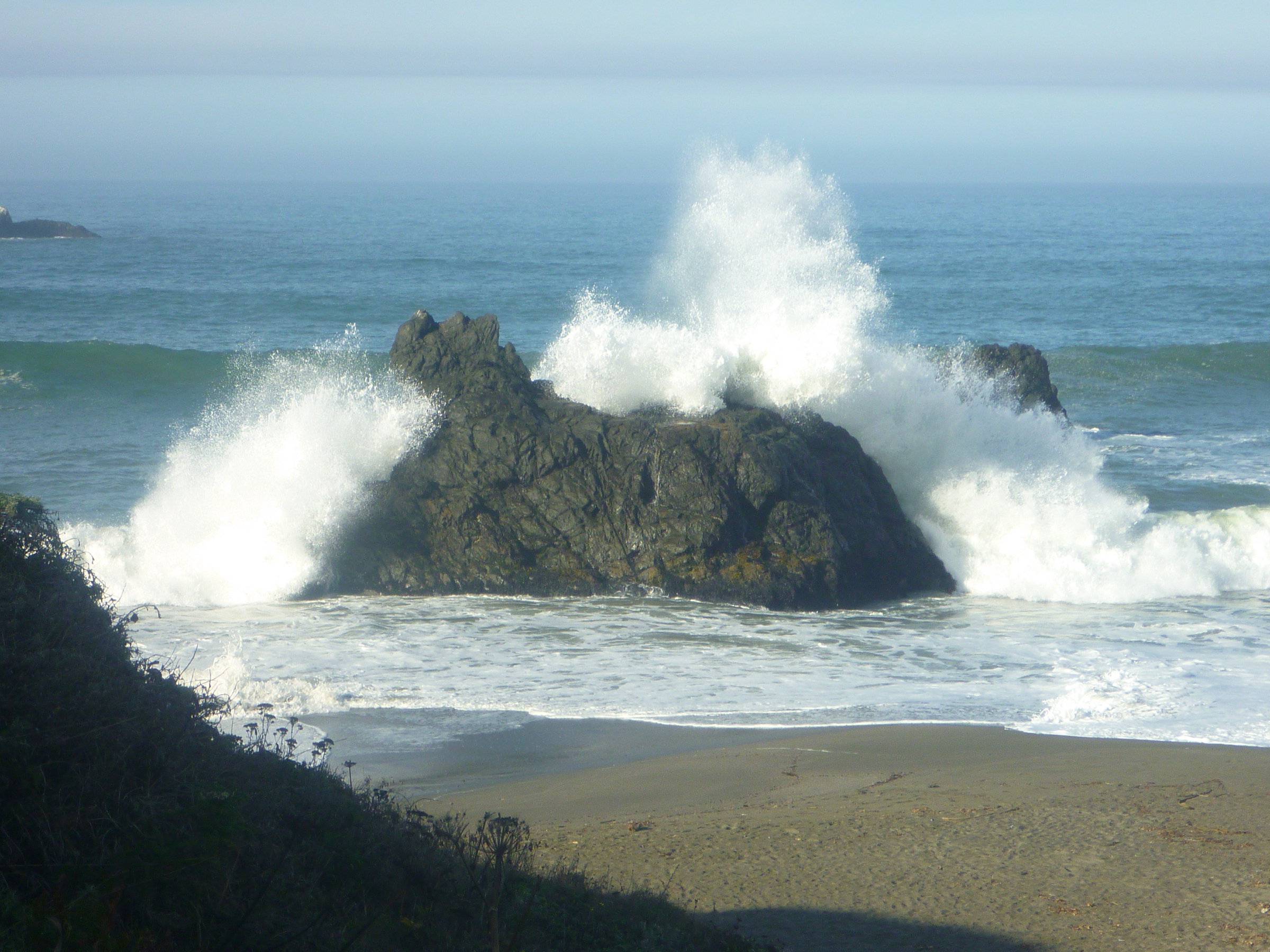
Splashing waves off the oceanfront cliffs

The Kortum Trail in the Sonoma Coast State Park in northern California parallels the Pacific Ocean from Wright's Beach to Blind Beach, from where you can—while being aware of danger zones and sleeper waves—continue to Goat Rock and beyond to the mouth of the Russian River. The trail is mainly winding across open coastal prairie along oceanside cliffs, offering stunning views of sandy coves and craggy, wave-breaking outcroppings [1-6].

Year-round, Kortum Trail lets you watch and enjoy the rhythm and drama of the rocky Sonoma Coast. Curious about earth movements or slides? Well, the San Andreas fault follows along offshore—making this coastline indeed unique and special.

Kortum Trail is named for the Petaluma veterinarian and environmentalist Bill Kortum (1927-2014), who fought to keep coastline access open to the public. Many are regarding Bill Kortum as the father of the Sonoma County environmental movement. He helped defeat a proposed power plant at Bodega Bay [2-4]. 

Herein, I am following the Kortum Trail from its south-end trailhead at Wright's Beach via Shell Beach and over the Peaked Hill to Blind Beach.

Downstairs to Shell Beach
At the Wright's Beach trailhead, you will find an informative board with a trail map and the warning that the rugged shoreline with its jagged rocks and hazardous surf is not for swimming. Actually, if you are just  following the well-marked hiking path, you will not reach the shore or surf level before reaching the Blind Beach/Goat Rock area. Kortum Trail mainly meanders through coastal bluffs from where you will experience sweeping views of the offshore sea stacks and the ocean surf from a safe distance.

About halfway between Wright's Beach and Blind Beach is Shell Beach. It takes five to ten minutes to take the stairs downhill to the beach—actually a small, scenic cove with not much beach left to scatter around at high tide.  

Shell Beach surf

Board walk through coastal prairie: northbound to the Gull Rock vista point

North of Shell Beach, rocks on both sides of the oceanfront cliffs will attract your attention: offshore Gull Rock as well as Mammoth Rock and the Sunset Boulders [5,6].

White bird droppings covering sea stacks (Gull Rock in the upper left quarter)

Gull Rock is the farthest offshore rock. This sea stack is “painted” white with bird droppings and serves as a nesting site for gulls and cormorants [2,3]. 

Mammoth Rock

On the coastal prairie side there are several outcroppings of archaeological and recreational interest. Collectively, they are called Mammoth Rocks or Rubbing Rocks. Archaeologist Breck Parkman thinks of these rocks as mammoth and bison grooming sites [5]. He wrote:

In 2001, I discovered what I believe to be Rancholabrean rubbing rocks on California's North Coast. These are features that I believe were used for grooming by now-extinct Ice Age megafauna such as Mammuth columbi and Bison antiquus. [...] The Mammoth Rocks site consists of four loci of rubbing rocks, separated by about 300 m. Two of the loci consist of very large blueschist seastacks (20 and 30 m tall). The other two loci are smaller blueschist boulders (4 and 5 m tall). The four loci surround an enigmatic wetland that I believe may represent a relic animal wallow. 


Sunset Boulders

During my late-October visit of the Mammoth Rocks this year, I saw people climbing to the top the Sunset Boulders, the northernmost rock formation of the “Rubbing site.”

Past the Sunset Boulders, Kortum Trail continues— over wooden steps—uphill over a saddle east of Peaked Hill and then downhill to Blind Beach. Arched Rock, Goat Rock and the Russian River State Marine Conservation Area are now coming in view. Here, I began my return hike and took my car to get to Goat Rock Beach and the sand spit between the final stretch of the Russian River and the open sea. 

Goat Rock


Getting to Kortum trailheads

From Bodega Bay, go north on Highway 1 for six to ten miles and select one of the multiple access points. The Kortum Trail stretches nearly four miles from Wright's Beach to Goat Rock.

Direction from Shell Beach

The trail is accessible from different road ends and parking lots including the few lots near the Wright's Beach campground and picnic area, the Carlevaro Way dead-end, the Shell Beach parking area, the Pacific View Drive dead-end, and from various sites along Goat Road including the Blind Beach parking area. 

From the Shell Beach lots, favored by many visitors, you have multiple hiking options: walking the easy southbound trail, hike northbound towards Gull Rock viewpoints, Mammoth Rock, Sunset Boulders, The Peaked Hill and Blind Beach, or take the short path down the stairs to Shell Beach.   


Map

The map, accessible by the following link, shows the trail section and sites between Shell Beach and Blind Beach including Peaked Hill, Mammoth Rock and the Sunset Boulders: https://www.google.com/maps/dir//Sunset+Boulders,+Kortum+Trail,+Jenner,+CA/@38.428139,-123.1197201,15z/data=!4m9!4m8!1m0!1m5!1m1!1s0x80869fac2db18237:0xcbf227d683480426!2m2!1d-123.1157319!2d38.4292347!3e0


References & further reading 

[1] Sonoma Coast State Park. PDF version: https://www.parks.ca.gov/pages/451/files/SonomaCoastSPFinalWebLayout2017.pdf.

[2] David Weintraub: North Bay Trails. Wilderness Press, Berkeley, 1999. See Chapter 46 - Kortum Trail; pp 244-247. 

[3] Robert Stone: Trail of the Week: Kortum Trail. Sonoma Magazine, June 2016. Website: https://www.sonomamag.com/trail-of-the-week-4/ (accessed on November 12, 2022).

[4] Bill Kortum 1927-2014. Sonoma County Conservation Action. Website: https://www.conservationaction.org/bill-kortum/ (accessed on November 12, 2022).

[5] E. Breck Parkman: Mammoth Rocks. California Department of Parks and Recreation.   Website: https://www.parks.ca.gov/?page_id=23566 (accessed on November 12, 2022).

[6] Patty Ginochio: Fragile Beauty - Sunset Rocks | Mammoth Rub on Kortum Trail at Goat Rock State Beach. Sonoma County Gazette, August 3, 2019. Website: https://www.sonomacountygazette.com/sonoma-county-news/fragile-beauty-sunset-rocks-mammoth-rub-on-kortum-trail-at-goat-rock-st/ (accessed on November 13, 2022).


Sunday, October 2, 2022

Ghost mill exploration: walking between big-mill walls and rubble

Trapezoidal-prism-shaped foundation of the Mangum Mill today (September 2022)

The ghost town of Aurora in Nevada has its ghost mill: the Mangum Mill.  The discovery of gold- and silver-rich ore in the second half of the 19th century triggered the foundation of mining towns north of Mono Lake—including Aurora [1-5]. Founded in 1860, one year after Bodie was established, the Aurora Mine Area (elevation around 7,500 feet) had a very short boom time; if any at all. Nevertheless, the mines were kept alive for some decades (see the Aurora Cemetery board section “Boomtown, Then Dust” [1]):

In the early twentieth century, the Aurora Consolidated Mines Company acquired property north of the old town and erected the big mill known as the Mangum Mill. While the company's activities brought some life back to Aurora, it was not a long-lived proposition, closing operations in 1918.

Today there is only rubble left, due to the fact that many buildings were disassembled and the bricks used to make them sold or stolen. Today, the US Forest Service manages a portion of the site.


Not stolen: concrete-anchored metal

The 500-ton mill is named for W. Lester Mangum, who, with Jesse Knight and three others, established the Aurora Consolidated Mines Company in 1912. Construction of the mill was completed in 1914 [2]. Although the company kept Aurora in its name, Aurora was not considered fit as the mining hometown. In the shadow of the mill, the company town of Mangum was established, because Jesse Knight, a member of the Church of Jesus Christ of Latter-day Saints, was displeased with the “sinful life” happening in Aurora. 

The Nevada Expeditions website describes the short time of the mills operation and its final fate [2]:

For the next few years and into World War I, the Aurora Consolidated Co. worked old mines and tailings, processing over 633,000 tons of ore and producing over $1.8 million. By 1918, a shortage of labor due to the war coupled with rising operation costs led to the mill's closure. It was soon dismantled, and both equipment and buildings were relocated to Goldfield and Mangum quickly became but a memory. Large foundations of the Aurora Consolidated Mill remain, but the site of Mangum has since been covered by modern day mining operations.     


Stay out of trouble—avoid the rubble!

Today, you can still walk between the remaining walls and rubble of the Mangum Mill. Its terraced foundation can be seen from the air [5]. It seems relatively safe to use the walk ways between the walls that occur on different terrace levels. All around, fallen rocks, wheels, beams and sharp or rusty metal pieces make for trip hazards. An occasional high-altitude rattlesnake may hang out in a rubble shelter during the hot summer months, although it is said they are seldom found much about 7,000 feet or higher. 

Today's Aurora landscape: Mill walls in front, high walls in the back


References and more to explore

[1] Aurora, Nevada. Ghost City of the Dawn. Humboldt-Toiyabe National Forest Board at the Aurora Cemetery site, Bridgeport Road, Nevada. 

[2] Mangum, Mineral County. Nevada Expeditions, 2013-2022. Website: https://www.nvexpeditions.com/mineral/mangum.php.

[3] Aurora, Nevada. Western Mining History. Website: https://westernmininghistory.com/towns/nevada/aurora/.

[4] Aurora. Atlas Obscura. Website: https://www.atlasobscura.com/places/aurora-nevada.

[5]  Drone footage of the Ghost Town of Mangum, Mineral County, Nevada. YouTube: https://www.youtube.com/watch?v=41EhnRRMRm0.

Inspiring Mangum Mill memories: beams below clouds

Wednesday, September 28, 2022

Carson Range recreation: from Spooner Lake to Marlette Peak, northwestern Nevada

Marlette Lake with Marlette Peak above Rocky Point 

The 6.5+-mile-long route (one way) from Spooner Lake to Marlette Peak (elev. 8780 ft) leads mostly through mixed forest—with the exception of the open-slope grandeur around the west and south side of the conic peak. Instead of starting at Spooner Lake, hikers and mountain bicyclists also like to travel the alternative route to Marlette Peak from Spooner Summit along the Tahoe Rim Trail.

Spencer's Cabin
Here, I am following the route starting at the trailhead in the Spooner Lake Management Area. A short walk from the parking lot west of Spooner Lake's dam takes you to rustic Spencer's Cabin. Following the wide path used by hikers and bicyclists, you soon will arrive at the kiosk with the Marlette Lake Trail sign. The 3.75-mile-long trail to the southern tip of Marlette Lake is a single-track, hiking-only trail; while the wide path—
Marlette Lake Trail sign
North Canyon Road
—also leads to the lake and is open for mountain biking.

About half-way along Marlette Lake Trail, you will pass the Woodcutter's Cabin site. Continue the steady climb until you get to a saddle separating North Canyon from the lake basin, then descend for a half a mile to the trout hatchery at Marlette Lake. 

Rocky Point with a stretch of Marlette Lake's shoreline

From the hatchery, it takes 0.3 miles along the northeast side of the lake to a road junction, from which you can access Rocky Point, return to Spooner Lake on North Canyon Road, or begin your climb to the Marlette Overlook and to the point where the road intersects with the Tahoe Rim Trail (TRT). 

On the way between Rocky Point and Marlette Overlook

Turn left on the TRT to the Marlette Peak Campground (Marlette PK CG). If you continue northbound on the TRT, halfway around Marlette Peak, you will get to a junction, where a post directs you to the South Marlette PK Loop and back to Marlette PK CG. 
South Marlette Peak Loop Trail

The South Marlette Peak Loop Trail is where you want to rest and celebrate the magnificent view of Marlette Lake, Snow Valley Peak, Lake Tahoe and the Sierra Crest in California.   

Marlette Lake with Lake Tahoe further back


Saturday, June 25, 2022

Lincoln Bypass Trail, Carson City, Nevada

Lincoln Bypass Trail near Carson City
Longview/Kingsview Way post

The Lincoln Bypass Trail connects Carson City with the trail system of the Kings Canyon waterfall area in the Humboldt-Toiyabe National Forest. This 4.4-mile-long hiking, mountain biking and horseback riding trail starts at the intersection of Kings Canyon Road and Longview Way in West Carson City and ends at the south trailhead of the Ash Canyon to Kings Canyon Trail. Today's Kings Canyon Road section between the Kings Canyon Rd/Longview Way trailhead and the Ash-to-Kings trailhead, which you are bypassing by using the accordingly named single-track trail, was part of the original 1913 Lincoln Highway.

Green band alongside the downhill path of water into Kings Canyon Creek 

The Lincoln Bypass Trail—completed in October by Sierra Trail Works & Muscle Powered—is much more than a bypass trail: it's a great addition to the Kings Canyon/Ash Canyon trail system. 

Prickly poppy 
Mariposa lily

The bypass trail is a scenic trail by itself. In late spring, Sierra/Great Basin wildflowers such as prickly poppies and Mariposa lilies are blooming alongside the path. Winding up through a short canyon at the edge of a Carson City neighborhood, the mellow-graded trail traverses a sagebrush plateau with amazing views of forested Carson Range slopes and continues through shrub, including snowbrush and wild rose shrub, before entering open pine forest, crossing Kings Canyon Creek and concluding its path at a stand of cedar trees. See the signpost below with directions for continuing on the Upper Waterfall Loop trail. The trail map at the kiosk on the other side of Kings Canyon Road shows the waterfall loop trail; but not the Lincoln Bypass Trail (as of June 2022).

Stand of cedars where the bypass trail continues to the Upper Waterfall  


Getting there

From the Nevada State Capitol Building in downtown Carson City, take West King Street and go west. West King Street continues as Kings Canyon Road. Find parking where Longview Way and Kingsview Way meet Kings Canyon Road. The trailhead is on the left side west of Kingsview Way. 


References and more to explore

[] Lincoln Bypass /mountain bike trail. Trailforks. URL: https://www.trailforks.com/trails/lincoln-bypass/.

[] Staff Report (Gregg Berggren, Trails Coordinator): Capital to Tahoe/Lincoln Bypass Trail. URL: https://www.carson.org/home/showpublisheddocument/77624/637696192196230000.

[] Lincoln Highway Era (1913-1928). URL: https://4thprater.onlinenevada.org/era/lincoln-highway-era.

[] The Lincoln Highway in Nevada. Nevada Magazine, March-April 2013. URL: https://nevadamagazine.com/issue/march-april-2013/539/.

Mountain bikers on track at a switchback of Lincoln Bypass Trail