Wednesday, July 22, 2020

Clipper City Rail Trail—the other half

Railroad remnant on Clipper City Rail Trail

The Clipper City Rail Trail (CCRT) connects the Newburyport MBTA station with the historic downtown of Newburyport and the harbor area. There is another CCRT half: its trailhead is located about 2000 ft east of the train station on Parker Street. From the CCRT trailhead arch at the MBTA station go east on Parker Street. After managing the Highway 1 traffic circle, continue east on Parker Street and find the CCRT trailhead on the left—just past the cemetery.
Railroad blocks next to Clipper City Rail Trail

Like the already highlighted first half, this CCRT section features nature, art and history alongside the paved trail. About one third of it is a greenbelt trail, the following third leads through neighborhoods and the final third is an open-air art gallery with paintings of local sceneries.

The following pictures showcase sites and art between you can find between Parker Street and Water Street, where the CCRT turns into the Newburyport Harborwalk trail.


Crab sculpture at High Street underpass

“Dog on bicycle” riding in a CCRT neighborhood garden

“Cat on bicycle” riding in a CCRT neighborhood garden

The art walk passage

“Swallows Over Plum Island” by Leah Grimaldi

“Men Clamming, Plum Island Basin” by Christine Bobek

“Yellow House, Water Street” by Cynthia Kowal

“Green Dory” by Marjet Lesk

“Bartlett Mall: A Hide and Seek Adventure” by Jason Harris

“Old South Church” by Susan Orfant

“Foggy Evening on the River” by Wenda Chelter

“Sunset at Joppa Flats” by Stephanie Noah

“Cross Farm Hill, Plum Island” by Skip Motes

“Boston & Maineat Water Street Crossing” by Alan Bull


“Dream” sculpture near CRRT/Water Street junction

Joggers on CCRT approaching Harborwalk trail


Note: All pictures were taken in mid-July, 2020.


Sunday, June 28, 2020

Clipper City Rail Trail


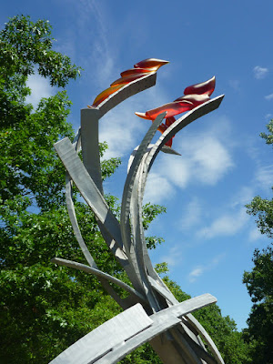
CCRT Wishbone
Wishbone” sculpture by Vermont artist James Irving (2010)

The paved, 1.1-mile-long, multi-use Clipper City Rail Trail (CCRT) connects the MBTA Train Station in Newburyport, Essex County, Massachusetts, with the Merrimac River estuary and seaport area. Various schooners such as the original Clipper City built in Manitowoc, Wisconsin, frequented the harbor of Newburyport in the 19th century. The rail-trail name commemorates these multi-masted sailing vessels.

When you arrive in Newburyport by train, exit the train and continue on the railway platform in northeast direction toward the Mark Richey Woodworking Arch—the CCRT starting point. The CCRT is a recreation trail that follows what once was the track of the Boston and Maine Railroad.
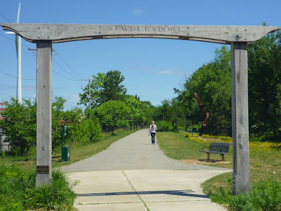
CCRT start at train station
Mark Richey Woodworking Arch north of Newburyport's MBTA station

Today, this greenway trail links Newburyport neighborhoods with each other: inviting foot travelers, dog walkers, joggers, skateboarders and bicyclists to make their way alongside sculptures and other points of relaxation, education and inspiration. 

In the following, I am tracing the CCRT from the woodwork arch to the riverside by highlighting selected trailside objects including historical and educational placards. The theme of the art work alongside the trail may be summarized as “animals, nature and dynamic forms.” The first sculpture, Sparrows” by Dale Rodgers (2011), shows two birds gliding side by side in vertically tilted posture.

“Sparrows” sculpture
Sparrows” by Dale Rodgers (2011)
                                                  
Next, you will arrive at the self-explanatory sign for Haley's Ice Cream. Continuing on the CCRT, you will pass the Alchemical Garden and a Little Free Library. You can't miss Clyde already waiting for you. “Clyde” is a horse sculpture by James Burnes (2009) made of corten weathering steel and black locust wood.
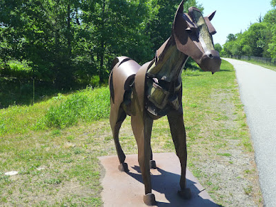

“Clyde”
Clyde” by James Burnes (2009)

The following two sculptures capture (un)balance and movement: “Eclipse” by Rob Lorenson (2010) shows a delicately positioned, leaning circle composition and “Torrential Flight” by Brian F. Russell (2009) gives the impression of two red gummy birds riding a whirlwind.
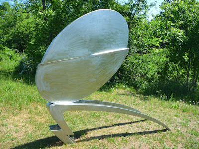

“Eclipse”
Eclipse” by Rob Lorenson (2010)


“Torrential Flight”
Torrential Flight” by Brian F. Russell (2009)

When reaching the limestone installation “Will He” by Simon LaRochelle (2008) you will be at the  CCRT midpoint. When I walked by in June 2020, the bicycle parts shown on earlier pictures of this sculpture were missing.

Soon I came to a historical placard presenting information on  the Newburyport Roundhouse:

The Roundhouse was used for servicing or storing steam engines. Steam locomotives often could not operate well in reverse, and the defining feature of the Roundhouse was the giant turntable that could spin an engine around and put it back on the track. Built in the late 19th century and situated where a private maintenance yard exists today, the Newburyport Roundhouse was closed on September 28, 1947.
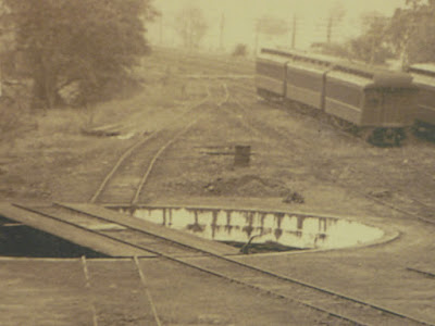

turntable
Turntable for steam locomotive

Nearby, bridge-embankment blocks have been placed in a pentagram arrangement. A placard on one of the granite blocks describes their history: 

These 19th century granite blocks once supported the old railroad bridge embankment at the Merrimack River. The blocks were relocated here in 2009 during construction of the Clipper City Rail Trail.

19th century granite blocks
Granite blocks once supporting railroad bridge embankment

Next to the granite blocks the steel “Steam Loco” play sculpture waits for children and their parents to explore the interactive train structure.  Also interactive: the sculpture “Wishbone” by Vermont artist James Irving (2010)—see top picture of this post—invites you to take the seat at the fusion of two red clavicles holding an orange ball or globe.

Ryan Kelley tree sculpture
Ryan Kelley sculpture given by the Friends of Newburyport Trees

After underpassing High Street wall-based sculptures are coming up. On the left side is a Ryan Kelley sculpture given by the Friends of Newburyport Trees. The wall across this tree sculpture features estuarian life: the “Great Blue Heron” by Bob Kimball (2010) and pl
xx  “Great Blue Heron” by Bob Kimball (2010) and “Native Fish” by Bob Kimball (2010).

“Great Blue Heron”
Great Blue Heron” by Bob Kimball (2010)


Details on the “Great Blue Heron” at given on the sculpture placard:

This sculpture was commissioned in memory of John P. Soward by his friends and family. John, a talented artist, lived for many years in the house on the other side of this wall. This sculpture is based on his painting of the great blue heron.

“Native Fish”
Native Fish” by Bob Kimball (2010)

Time to dive into local history again, The board with the title “The 1873 Train Wreck at Merrimac Street, Newburyport” describes a  “lucky accident” without fatalities:

A misplaced switch forced a freight train onto a dead-en side track on May 23, 1873, and the 34-ton steam locomotive smashed through barriers and fell down the embankment to Merrimac Street below. The engineer and fireman jumped clear before the impact. Fortunately, no one was hurt in the dramatic accident, and the engine was back on the track two days later.
train wreck
The 1873 Train Wreck at Merrimac Street, Newburyport

Still on the track, one soon reaches the CCRT vista point with views of the Merrimac River.

The viewing platform has benches and is distinctively marked by the sculpure “G-Swirl” by Dale Rogers (2010).
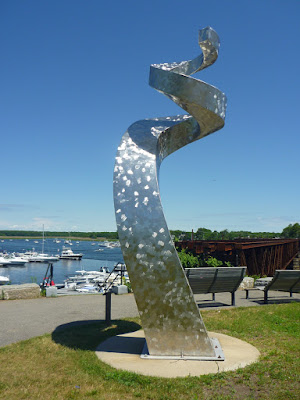
“G-Swirl”
G-Swirl” by Dale Rogers (2010)


Old railroad bridge over Merrimac River


Note

Most of the descriptions and data in this post are based on the state at which objects and placards were found alongside the CCRT in June 2020. Additional information can be found on selected websites given below. 


References, further reading & more to explore

Mark Favermann: From Train Tracks to A Public Art Walk. Berkshire Fine Arts, Dec. 17, 2011. Link: https://www.berkshirefinearts.com/index.php/12-17-2011_from-train-tracks-to-public-art.htm.


Clipper City Rail Trail (Newburyport, MA). New England Nomad. June 23, 2016. Link: https://newenglandnomad2015.com/2016/06/23/clipper-city-rail-trail-newburyport-ma/,


Saturday, May 9, 2020

Total Recall Trail: uphill with Peavine Peak in view

Peavine-Trails mountain bikers
Colorful mountain bikers on Total Recall Trail

Peavine Mountain
Peavine Peak seen from Total Recall/Stage Coach trail junction

The Total Recall Trail connects the Keystone Canyon north of Reno with the Lingles Loop area of the Peavine Trails network. This single-track hiking and mountain-biking trail begins at trail marker 60 on the Keystone Canyon Trail.

Total Recall Trail starting out of Keystone Canyon

First, it leads north-northwestward to junctions with the Stage Coach Trail and Poedunk Trail. The radio towers are always in view. Total Recall climbs up to its junction with the Halo Trail and further onto the ridge with the Rock Pile and the bench. This is the the other end of the Stage Coach Trail (trail marker 65)—obviously, you have various loop options here. This ridge-top trail junction offers scenic views of Mount Peavine. It is a meeting and socializing hot spot, currently with social distancing rules you want to keep continuing with by following the temporary Covid-19 directional trail recommendations

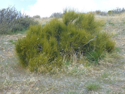
Mormon Tea
Mormon Tea brush (green ephedra) next to Total Recall Trail

After a short downhill hike or ride and a pleasant valley-meadow section, Total Recall ascends toward the Lingles Loop, Bobsled, Colpo Cyn and Scrub Brush Trail.


Dwarf onions
Dwarf onions flowering off Total Recall Trail

To get back to the Keystone Canyon, you may want to consider taking the short Over Easy Trail at the south tip of the Lingles Loop and then follow the Bacon Strip and Halo Trail downhill to the Snow Terraces, from where the Snow Terrace Snow Terraces Trail and Fisticuffs Trail leads you down into the canyon.


More about Total Recall Trail

Total Recall is a popular mountain biking trail: a 3.1-mile-point-to-point singletrack rated as intermediate with an average grade of 6% and a maximum grade of 17%.

Sunday, April 19, 2020

Switching (off) the fear factor on Peavine Trails

Currently, you will find more COVID-19 recommendation posts than rattlesnake warning signs along the Peavine Trails—a networks of hiking & mountain biking loops and trails northwest of Reno, Nevada. The recommendations have been posted to remember trail users how to manage avoiding the spread of the SARS-CoV-2 virus, a coronavirus that can cause the respiratory disease COVID-19.

Even outdoors in open space, social distancing is key. To minimize the chance that hikers, joggers and cyclist may run into each other, the temporary directional trail recommendations are set up such that many of the single-track trails are suggestively turned into one-way paths. “Direction Suggested” and  “Direction Not Suggested” signs have been posted. Either type asks people to remember the following:

Announce Yourself Early to Others

“Be Nice - Say Hi” and Smile when Passing

Move at Least 6 ft off Trail when Passing

Avoid Congregating at Intersections.

It works. There is nothing to fear and lots to enjoy. The value of a recreational trail network next to urban neighborhoods is priceless—anytime.

The posted signs you temporarily will see at many trail junctions and intersections:


COVID19 temporary trail recommendation: Suggested Direction

COVID19 temporary trail recommendation: Direction Not Suggested


Sunday, September 22, 2019

Cold Creek Trail 18E06

Cold Creek: unnamed waterfalls
Cold Creek Trail is a single-track trail leading from South Lake Tahoe, California, uphill to High Meadows. The 2.5-mile-long trail follows Cold Creek along the left (north) side. Almost level at its beginning near Powerline Trail, Cold Creek Trail continues as a sequence of switchbacks. It is popular with mountain bikers—and over certain sections quite a challenge. Hikers love this shaded creek & forest trail as well.

Cold Creek Trail near Powerline Trail
My Lake Tahoe Basin Trail Map marks Cold Creek Trail with two black diamonds—for “expert” use. Indeed, you need to master a few steep and rough rock jumps. I have seen many riders walking their bike at those locations. Half-way up you will pass by a few insignificant, yet beautiful waterfalls; where you may want to take a break and refresh. The trail mellows out as you are getting close to the meadows. Here, Cold Creek slowly meanders through brightening mixed forest.

Granodiorite rocks next to Cold Creek Trail
Cold Creek Trail ends at a creek crossing. Actually, it splits into two trails. One path continues uphill for another two miles to Monument Pass and the Tahoe Rim Trail (TRT). The other, across the creek, starts out as High Meadow Road, which you can take to get back to South Lake Tahoe and Meyers. The latter also connects with the 3.1-mile long Star Lake Trail—accessing Star Lake, the TRT and the Freel Peak surroundings within the Carson Range

Cold Creek at High Meadows


Friday, August 30, 2019

On and off the PCT: climbing Mount Lincoln


Pacific Crest Trail south of Mount Lincoln
Looking south from Mount Lincoln: the PCT follows the Pacific Crest toward Anderson Peak
Mount Lincoln, like Mount Judah, is an easily accessible peak in the Sierra Nevada located south of Donner Pass—west of Truckee, California. The Pacific Crest Trail (PCT) passes through between these two peaks. The gap in-between is known as Roller Pass or Judah-Lincoln Pass. Whereas Mount Judah is accessible via the popular, well-signed Mt. Judah Loop Trail, which shares a 1.1-mile-long trail section with the PCT, “Mt. Lincoln Trail” is an unsigned use trail.

A snow-covered section of the PCT near Roller Pass
Mount Lincoln's east-side slopes: sections of the PCT still snow-covered (mid-August, 2019)
From the Donner Pass, hike south on the PCT for about three miles. Once you are leaving the forest of the Roller Pass area, continue on the PCT traversing the steep eastern slope of Mt. Lincoln. Watch out for the junction, from where a narrow trail winds up to Mt. Lincoln. With the ski lift installation on the top of Mt. Lincoln always in sight, it is easy to stay on track. The panoramic view is amazing.

Pacific Crest lichen
Lichen patterns on a rock next to Mt. Lincoln Trail with Anderson Peak and Tinker Knob in the background

The winter ski area boundary on top of Mount Lincoln

Sugar Bowl in August
Sugar Bowl summer-view from Mount Lincoln with Castle Peak in the far back


Tuesday, August 20, 2019

Roller Pass—also known as Judah-Lincoln Pass


PCT at Roller Pass
If it weren't for the “Truckee Trail - Roller Pass” marker on the Pacific Crest Trail (PCT), most hikers would not notice they are passing a historical spot. The PCT—between Mt. Judah and Mt. Lincoln—is an almost level path through forest. Difficult to believe that the PCT here intersects an old wagon route.

E. W. Harris made three hikes to Roller Pass in the summer of 1977. He did review the history of emigrant parties in the Donner area and described the Roller Pass topography in detail [1].  The Roller Pass was discovered in 1846 by Joseph Aram, who was with a party of about twelve families on his way from Illinois to Santa Clara Valley [1-3]. Until then, the Donner Pass (Truckee Pass) was used to go west. Pausing at Truckee Lake (now Donner Lake), the Aram Party, guided by Chief Truckee, explored for an easier crossing of the Sierra Ridge. Referencing an article in the Journal of American History, Harris writes [1,4]:

Finally Aram turned to the southwest following Cold Creek to its confluence with Emigrant Creek and thence (presumably) to its head along Emigration Canyon. Here they reached the pass between Lincoln und Judah peaks, and found it incredibly steep for wagons, some 800 feet higher than Truckee (Donner) Pass, but in the final analysis easier for wagons.

PCT near Roller Pass with view of Mt. Lincoln
To get to “the pass between Lincoln and Judah peaks” today, follow the PCT south from the Alpine Skills Institute, 11400 Donner Pass Road, Truckee, CA 96161. It takes 1.3 miles to the first PCT/Mt. Judah Loop Trail junction and another 1.1 miles to the second junction. Continue southward on the PCT for a quarter mile and you will find yourself on Roller Pass—ready to begin your own analysis.

References and more to explore

[1] E. W. Harris: The Early Emigrant Pass between Mt. Judah and Mt. Lincoln.  In: Nevada Historical Society Quarterly, Spring 1979, Volume XXII, Number 1, pp. 31-39 . Link: epubs.nsla.nv.gov/statepubs/epubs/210777-1979-1Spring.pdf.
[2] Capt. Joseph Aram. Link: http://www.mariposaresearch.net/santaclararesearch/SCBIOS/jaram.html.
[3] Roller Pass. Donner Summit Historical Scociety. Link: http://www.donnersummithistoricalsociety.org/pages/JudahLooppgs/RollerPass.html.
[4] Joseph Aram,  “The Reminiscences of Captain Aram,” in James T. Watson, “Across the Continent in a Caravan,” Journal of American History, 1907, Vol. I., #4, 628.