Saturday, May 21, 2016

Going north: a visit to the windmill in Rekum, Bremen, Germany

Rekumer Mühle: horizontal windshaft carrying four sails
Traditional windmills (Windmühlen) and drainage canals (Fleete) in and around the city of Bremen in northern Germany are a reminder that the Netherlands are not very far away. The windmill in downtown Bremen is a landmark. Every visitor who walked the short distance between the central train station and the historic inner city (Innenstadt) has seen it. Bremen has another windmill, also in a beautiful setting: the windmill in Rekum (Rekumer Mühle), which is over 35 km away from Bremen's center. It is rarely visited, but certainly worth it. A Rekum windmill side trip may be combined with a visit to the Valentin submarine factory remembrance site.

Rekumer Mühle, a windmill of the Wallholländer type
The Rekum windmill is located in the Rekumer Geest, a hilly landscape making up the northern tip of  Bremen and continuing on into Lower Saxony. The windmill is located on one of those windy hills. To increase the wind exposure, the mill was built onto an artificial mound (earth wall). This mill type is called a Wallholländer or Bergholländer, literally meaning wall-Dutch (type) or hill-Dutch (type), respectively. The mill building has an octagonal foundation. It features four sails consisting of a lattice framework, over which sailcloth were spread. Like the surrounding farm houses, the mill top is thatch-roofed.

The Rekum mill was built in 1873. A severe storm in 1962 destroyed its top parts. Thereafter, the mill was stepwise restored and is now a designated historic-cultural monument [1].


Getting to the Rekumer Mühle from the Bunker Valentin

Framework-structured house next to the Rekumer Mühle
From the “Annihilation through work” sculpture at the northeast corner of Bunker Valentin, walk eastbound along the street called Rekumer Siel and turn right on Rekumer Straße. Follow this road for about 10 minutes, turn right on Hospitalstraße and continue on this street for less than ten minutes until you get to the Y-junction, at which the inclining road An der Rekumer Mühle leads you uphill to the site of the mill, on the left side of the road. Yes, it has a street address: An der Rekumer Mühle 12 [2].


References and more to explore
[1] Wikipedia:  Rekumer Mühle [de.wikipedia.org/wiki/Rekumer_M%C3%BChle].
[2] Freie Hansestadt Bremen - Landesamt für Denkmalpflege: Rekumer Mühle [denkmalpflege.bremen.de/sixcms/detail.php?gsid=bremen160.c.16769.de].

Friday, May 20, 2016

A memorial roundtrip: visiting the Valentin submarine factory on the Weser River at the Bremen suburb Rekum

View through the floodable-dock hall toward the sluice gate of the never completely finished Valentine submarine factory
The Valentine submarine factory, Bunker Valentin, was built during the second half of World War II to assemble submarines from parts that were prefabricated in Bremen, Hamburg and Gdańsk. The unfinished Bunker with its several-meter-thick walls and roof was constructed from ferrous concrete to withstand air-raid bombing. A picture below shows that precision bombing toward the end of the war, when the Allies gradually gained supremacy in German airspace, produced partial damage, anyway.

Overall, the nearly completed, fortified U-boat facility survived. Post-war bombing did not succeed in destructing the massive shelter. For a short time in the 1960s the bunker served as a storage depot for the German Navy. In January 2011, it became the Denkort Bunker Valentin memorial, encouraging visitors to learn about the bunker's past—about the twenty months from summer 1943 to spring 1945 during which the bunkered shipyard was constructed under inhumane conditions by concentration camp prisoners and other forced laborers.

Footpath and levee southwest of Bunker Valentin
Once a place of ill-fated ambition and terror, now it is a site of remembrance. Today's setting of the bunker on the Weser riverbank in the Bremen suburb of Farge-Rekum in northern Germany—surrounded by trees and trails including a bike path alongside an otherwise idyllic stretch of the river—may make sightseers forget about the dark history of this site. One cannot fail to notice the colossal structure. Bernd Hettlage writes [1]:

The aura of this building, its sheer monumentality, is overwhelming. The bunker is more than 400 metres long, more than 30 metres high, and almost 100 metres wide at its western end. It is the second biggest facility of its kind ever built above ground in Europe. Today its walls of black-stained concrete, partly overgrown with creepers, purvey a morbid atmosphere - a ruin, created as if for eternity.

Irreparable damage of the bunker roof
Approaching the site on the levee from the south, you will first see the specially dredged Weser bay in front of the bunker's west side with the sluice gate. Since the actual assembly of submarines never happened, the bay-sluice cutoff was not carried out: submarines were never launched onto or into the Weser river. From the trail at the northwest corner of the bunker you are getting a view through the floodable-dock hall toward the northeast corner, where concrete parts are hanging down as a result of Allied bombing in March 1945. Some birds and many bats make the cave-like interior with its cold gloom their habitat.

As you continue on, you get to a T-junction, at which a bike-path sign tells you that the center of Bremen is 36.5 km away. Turn right to circumvent the bunker. Signposted walkways give information on what took place during the construction of the U-boat bunker. Framed floor panels remember some prisoners who suffered, were beaten and tortured, and died here. While the armaments infrastructure around the bunker and the camps that housed the prisoners were destroyed after the war, the indestructible monster building, which some wanted to see being covered by sand, stayed in place.
“Annihilation through work” sculpture

At the northeast corner of the bunker rectangle, you will find the concrete sculpture with the title “Annihilation through work.”  This memorial sculpture was created by the Bremen artist Fritz Stein and was unveiled in 1983. Walk south and then west alongside the south-facing concrete wall to get to the main entrance of Bunker Valentin and its documentation center.   

Getting to the Denkort Bunker Valentin site

From the Hauptbahnhof (central train station) in Bremen, take the NordWestBahn train via Vegesack to Bremen-Farge. There, you may want to continue by bus (the bus stop is on Farger Str.) or hike alongside the Weser river.

The bus option is the BSAG Line 92, northbound. Exit the bus at the Rekumer Siel stop and walk the short distance along Rekumer Siel street to the “Annihilation through work” sculpture and the bunker.

To hike or bike to the bunker, follow Farger Str., which turns into Rekumer Str., northbound. Turn left on Unterm Berg, where a sign tells you that it is 2.0 km to Bunker Valentin. Pass the Rathaus (city hall) on its left side. Continue to and pass the Jugendfreizeitzeitheim Farge until you see the levee and the river. While continuing north on or next to the levee, the concrete giant is coming into view.

Note that bicycling is restricted on certain paths next to the bunker.

There is no admission. An on-site welcome panel includes the following request:

Visitors are requested to conduct themselves respectfully, as befits the significance of the historic site. No bicycling or dogs allowed (except assistance dogs). Walking outside the designated areas occurs at your own risk. Concrete pieces may fall down. Parents are responsible for their own children.

References and orientation
[1] Bernd Hettlage: “Bunker Valentin” Remembrance Site and Documentation Centre.  Gedenkorte Nr. 12. Stadtwandel Verlag, Regensburg, 2015.
[2] David Crossland: Germany opens former U-boat bunker as museum to Nazi inhumanity. The National, May 31, 2011. www.thenational.ae/news/world/europe/germany-opens-former-u-boat-bunker-as-museum-to-nazi-inhumanity.
[3] Denkort Bunker Valentin: denkort-bunker-valentin.de/startseite.html. English version: denkort-bunker-valentin.de/fussbereich/englisch.html.
[4] Detailed Terrain Map of Rekum: www.maphill.com/germany/bremen/bremen/bremen/rekum/detailed-maps/terrain-map.

Saturday, May 14, 2016

A walk through Borgfeld to the Hollerdeich and its viewing tower, offering wetland vistas

Borgfelder Wümmewiesen with Deichschlot, Bremen-Borgfeld, Germany

Borgfeld's development began as a rural settlement at the Wümme River about 800 years ago. It became a district of the city of Bremen, Germany, in 1945. This quaint neighborhood can easily be accessed from downtown Bremen by tram. Line 4 takes you there. From the Borgfeld tram stop it only takes a short walk to get to Borgfeld's center around the church with a history going back to the 13th century.

Building of the Wümmehof complex
Various architecturally interesting cottages and farm houses make up this affluent neighborhood of Bremen. On your way to the Wümme wetlands, you are getting a peek of some of Bremen's most valued real estates, including the historically significant Wümmehof, which—designed in 1938 by the architect Eberhard Gildemeister (1897-1978)—has been, for over 40 years, the family home of Louise Ferdinand Prinz von Preussen, the grandson of Germany's last emperor. Over these years, it also served as the administrative seat of the dynasty of the House of Hohenzollern. A much older building, Borgfeld's church was mentioned in the 13th century; the time after which the area was drained and cultivated by Dutch people, commissioned and financed by local clerical authority.
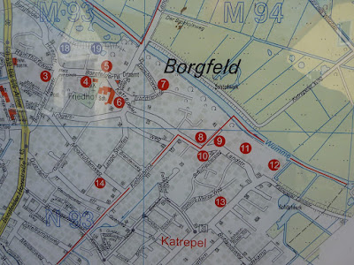
Map of Borgfeld highlighting points of interest
Following, from the tram stop, the route Hamfhofsweg, Borgfelder Landstraße and Katrepeler Landstraße (see Borgfeld map above), you will pass a string of places of interest, including the old church 4, the Ratsspieker (farm house with ballroom) 5, the rectory 6, the Alter Hof Klüver (Clüver farm house, 16th century) 8, the Wümmehof  9, the Wikingborg (Parchmann farm house) 10, the Meierhof of the Kloster Lilienthal (building of the former monastry of Lilienthal) 11 and the Kattenburg (formerly Kattenborg, residence of merchant and Africa explorer Franz Adolf Eduard Lüderitz (1834-1886)) 12.

By now, you certainly have realized that Borgfeld is more than an ordinary village-turned-suburb district. If you mainly came to see the open-space wetlands, you are almost there. The Katrepeler Landstraße continues on a levee. It turns into Am Hollerdeich (Deich meaning levee) and soon you will arrive at the Beobachtungsstand Hollerdeich—an observation tower on the right side of the road.


Hollerdeich observation tower

From the top of this small tower, one can enjoy great views of the Borgfelder Wümmewiesen, Bremen's largest nature preserve. The Wümme River is gently traversing the meadows. Various ponds and canals can be seen on both sides of the main river. The canal next to the levee is called Deichschlot—its name expresses that it is extending alongside the levee. During winter months, the meadows are often flooded.

The Wümmewiesen were agriculturally used in the past, but since 1987 they constitute a federally supported nature preserve. It is ecologically important, as various endangered plants and birds make this wetland their habitat. Other birds are passing through during migration. The small number of native Fischotter—Old World otters (Lutra lutra)—are living from fish they find in the streams and streamlets.

A panel at the observation tower informs about the locally endangered Sumpfdotterblume—marsh-marigold (Caltha palustris)—with its nectar-rich yellow flowers, which attract diverse insect species. The seeds contain small air pockets, such that the seeds float on water and promote the plant's spreading along river banks. Water birds also disperse the seeds, resulting in a marigold-dotted marsh during the spring season.

Borgfelder Wümmewiesen
Map of Bremen's largest nature preserve: the Borgfelder Wümmewiesen

Suggested browsing and reading
[1] Freie Hansestadt Bremen, Ortsamt Borgfeld: Borgfeld ein Dorf mit Geschichte [www.ortsamt-borgfeld.de/sixcms/detail.php?gsid=bremen150.c.1699.de].
[2] Schutzgebiete im Land Bremen: Borgfelder Wümmewiesen [www.erlebnisraum-natur.de/fileadmin/user_upload/bilder/Publikationen/Faltblaetter/NSG-Borgfelder-Wuemmewiesen.pdf].

Saturday, May 7, 2016

A short birchlined path alongside Bremen's historic “Kuhgraben” canal: the “Friedrich-Bremermann-Weg”

Friedrich-Bremermann-Weg alongside Bremen's Kuhgraben
The Friedrich-Bremermann-Weg is a birchlined path on a levee that follows the Kuhgraben within the neighborhood of the University of Bremen (Universität Bremen) in the city of Bremen in northern Germany.

This path is named in honor of Friedrich Bremermann (1889-1980), who established a home for riparian water sport at the Kuhgraben, called Wassersportheim Bremermann. It included a boat house, a workshop and a small harbor. The Wassersportheim had to give way for the construction of the university in the 1970s. In 2014, city authorities allowed Bremermann's two daughters, Ilse Stange and Helga Bremermann, to put up a sign remembering her father and the Wassersportheim [1]. And the once unnamed path alongside the Kuhgraben became the Friedrich-Bremermann-Weg, a scenic little path for a short stroll between classes and seminars or to warm up for a longer hike or run through the Wümmeniederungen—the wetlands of the Wümme river system.

The Kuhgraben is introduced by a small informative panel on site, saying that the exact origin of this canal is not known, but it has been mentioned as early as in the 13th century. Built for drainage and boat traffic, the Kuhgraben once connected Bremen with nearby Borgfeld and Lilienthal. Within Bremen, there were waterway connections with the Dobben and the Weser River. Especially peat—the main energy source during Bremen's early days—was shipped via the Kuhgraben and joined canals in the past.

Composed of the words Kuh and Graben, the name Kuhgraben may be thought of to literally mean cow ditch or cow canal. However, Kuhgraben derived from cograve (mentioned in 1277), containing the word co that became koh, meaning border [2]. Cograve referred to a canal that establishes an administrative boundary.     

The Friedrich-Bremermann-Weg runs parallel to the Kuhgrabenweg on the other side of the canal. The latter is open to non-motorized traffic and turns into a highly frequented bike path on sunny holidays. Halfway between the Universitätsallee and the Hochschulring, a foot bridge connects the Friedrich-Bremermann-Weg and the Kuhgrabenweg.

Getting there
From downtown Bremen take the tram line no. 6 (Linie 6), northeast-bound to the university (last stop: Universität/Klagenfurter Straße) and exit at the Universität/ Naturwissenschaften 1 stop (see: map) on Universitätsallee. Follow the sidewalk of this street, northwest-bound, towards the “silvery whale” (Science Center). Continue on the sidewalk to the Friedrich-Bremermann-Weg/Universitätsallee junction next to the Kuhgraben; across the Haus am Walde, a restaurant with a coffee and beer garden. Usually, it takes about fifteen minutes to get from the Universität/NW1 stop to the beginning of the Friedrich-Bremermann-Weg.


In the map above, the Friedrich-Bremermann-Weg is indicated by a grey dashed line following the right side of the Kuhgraben northeast of the red circle.

References
[1] Renate Schwanebeck: Bremermann als Namensgeber. Weser-Kurier, 25. Mai 2014 [www.weser-kurier.de/bremen_artikel,-Bremermann-als-Namensgeber-_arid,858262.html].
[2] Chronik Horn-Lehe: Kuhgrabenweg [www.chronik-horn-lehe.de/Strassen/Kuhgraben/Kuhgraben.htm].

Thursday, April 7, 2016

Blackwell Foothpath through Bussey Brook Meadow, a 1996-addition to the Arnold Arboretum

Blackwell footpath trailheadThe Blackwell Footpath connects the South Street Gate in Boston's Arnold Arboretum with the Washington Street Gate southwest of the Forest Hills MBTA Station. Within minutes, you can be in an urban ecosystem and protected landscape, while leaving the train station. After passing the Blackwell Footpath rock, shown above, the trail descends into Bussey Brook Meadow. A Welcome panel describes the meadow path as follows:

As you walk the Blackwell Footpath notice this urban wild is different from the rest of the Arnold Arboretum landscape. The Arboretum is managed through a unique public-private partnership between the City of Boston and Harvard University. Bussey Brook Meadow was added to the Arboretum in 1996 through the generosity and dedication of the Arboretum Park Conservancy.

Blackwell Footpath
The Arnold Arboretum is an urban park dedicated to nature studying. Alongside the Blackwell Footpath you will find a few display panels featuring birds of Bussey Brook Meadow, vines and plants gone to seed in the meadow, including Queen Anne's lace, milkweed, tansy, bittersweet, hickory, porcelain berry, crabapple, virginia creeper and staghorn sumac (also written stag-horn sumac or stag's horn sumach). The latter, Rhus typhina, is a flowering plant of southeastern Canada, the northeastern United States and the Appalachian Mountains. Small trees grow next to the footpath. The picture below shows a plants with its alternate, pinnately compound leaves, hairy stems and velvet twigs, and a cone-shaped cluster of fuzzy, red berries.

Staghorn sumac (Rhus typhina) next to Blackwell Footpath

What is now the Arboretum landscape were farms and orchards in the past. Then and now, the north-facing slope of Peters Hill features fruit trees. The Welcome panel says:

In the past this land was farmed , then  abandoned, then used as a dump. Plants here are historically native to this area, many are invasive, and some are exotics that have self-seeded from across the street. Many birds and animals inhabit this place as well.

The urban wild continues east of Bussey Brook Meadow as a patchwork of forest-like tree stands with cultivated areas including special gardens and plant collections. Farther northwest you'll find another beautiful path, the Linden Path, cultivated areas such as the Leventritt Garden and the Hunnewell Building housing the Arboretum's visitor center.

Monday, April 4, 2016

A drumlin in the Arnold Arboretum: Peters Hill—the third-largest hill in the Boston area of Massachusetts

Peters Hill summit
A vista point in the Arnold Arboretum: Peters Hill summit

Boston's Peters Hill in the south part of the Arnold Arboretum is a 240-feet-high drumlin. To get there from the Hunnewell Visitor Center at the other end of the park, you may want to walk southbound via Linden Path, Leventritt Shrub & Vine Garden, Bussey Hill Road, Valley Road, and Conifer Path to the Walter Street Gate, from where you can access Peters Hill Road surrounding Peters Hill. Various small trails lead up to the top and over the hill sides.

From the top of Peters Hill, Boston's skyline is visible. On a clear day high-rises such as the Prudential Tower, Hancock Tower, One Boston Place and the Federal Reserve Bank building can be seen. The distance between the Peters Hill summit to the Hancock Tower is 4.23 miles, according to an information panel.

Various fruit trees including crabapples grow on the gentile slope just downhill from the summit. The panel explains:

They were mostly planted in the 1940s and '50s. Before this was the Arnold Arboretum, colonial farmers planted fruit tree orchards on this same hill. They made cider and fed their animals on the fruit that fell from the trees.

Switching from agricultural history to geology, we also learn that beneath Peters Hill a probably unique type of rock is present, called Roxbury puddingstone. Peters Hill and other hills in the Arboretum were formed when glaciers altered the landscape. These drumlins consist of debris—sand, rocks, gravel, boulders—piled up thousands of years when glaciers melted. Peters Hill is merely one of many sites in and around Boston that gives evidence of ice age activity in this area [1]. Estate gardener and garden writer Danial Mount mentions three drumlins. He explored a drumlin a day [2]:

I gave  myself a generous three days to wander over and around the three drumlins that punctuate the topography of the Arnold Arboretum. It is a landscape shaped by glaciers, with outcroppings of Roxbury puddingstone and swampy lowlands, and has the third-largest hill in the Boston area, Peter's Hill, with a 180-dgree view of downtown Boston.

References and more to explore
[1] Arnold Arboretum - teacher guide [bostongeology.com/geology/fieldtrips/teacher/arboretum.htm].
[2] Daniel Mount: Boston's Arnold Arboretum: A Multihued Jewel. Summer 2012, page 13 [www.mountgardens.com/articles/Boston_Arnold_Arboretum.pdf].

Saturday, April 2, 2016

The Linden Path in the Arnold Arboretum

Linden Path in the Arnold Arboretum, Boston, Massachusetts
The quarter-mile-long Linden Path in the Arnold Arboretum is a beautiful trail that connects the Hunnewell Visitor Center at the northern tip of the tree park with the Leventritt Shrub & Vine Garden. It starts on the right side of Meadow Road southwest of the Hunnewell Building. First-time visitors of the Arboretum often begin their park exploration along this path, at the end of which the agriculturally landscaped Leventritt Garden, an open-air pavilion and the Larz Anderson Bonsai Collection await them.

Various linden trees (genus: Tilia) from around the temperate Northern Hemisphere can be found alongside the Linden Path. Grown Tilia trees are typically tall— sometimes over 100 feet. They have a sturdy trunk with dividing and subdividing branches ending in twigs along which heart-shaped leaves move in the wind and reflect the sunshine. The abundant foliage of summer trees gives plenty of shade on sunny days, but spending too much time underneath a fragrant tree can result in a sticky coating of body parts and accessoires, due to the sap dripping off the tree.

Moltka-Linden, Arnold Arboretum
The Moltka-Linden (Tilia x moltkei) shown above is a great example of a space-demanding tree with a strong branch structure. It is a cross breed of the American linden (Tilia americana) species and the silver linden (Tilia tomentosa) of southeastern Europe and Asia Minor, interbred in the 19th century at a tree nursery (Baumschule Späth) in Berlin, Germany. The hybrid is named after the German Field Marshal Helmuth Karl Bernhard Graf von Moltke, who, for some time, served with the Ottoman Empire in Asia Minor, where he may have temporarily retreated under a Silber-Linde from military duties. 

The Caucasian Linden (Tilia dasystyla) picture below features a twig hugging the lower part of the central trunk. The leaves show signs of insect attacks.  The label attached to the tree bark says this species is native to Southeastern Europe, the Caucasus (therefore its common name!), and Iran.

Caucasian Linden twig hugging tree trunk

Keywords: tree walk, Tiliacea, Tilioideae, Malvaceae, botany.

References
Von Moltke Linden: www.cirrusimage.com/tree_moltke_linden.htm.
Moltke-Linde (in German): de.wikipedia.org/wiki/Moltke-Linde.