Tuesday, May 28, 2013

Purple Nama (Nama aretioides)

Flowers of purple nama, also ground nama (Nama aretioides)

Purple nama (Nama aretioides) in dry habitat, north of Reno, NevadaPurple nama (Nama aretioides) is a small annual flowering plant growing on dry and sandy ground at low elevation in the Great Basin and other parts of the western United States. For example, in the Reno-Sparks area in northwest Nevada, the lower, south-facing slopes of Mount Peavine and the Hidden Valley Regional Park hillsides are good places to find patches of purple nama—usually flowering in May.
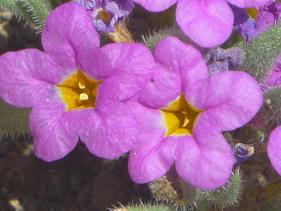
The delicately veined, tubular flowers are radially symmetrical with five petals. The corolla is pink-purple at the outside and has a white-yellow central tube. The oblanceolate-shaped leaves are crowded with silver-gray hairs.

Purple nama is also known as ground nama. Depending on the source, this plant species is placed into the waterleaf family (Hydrophyllaceae) or as a member of the subfamily Hydrophylloideae into the forget-me-not family (Boraginaceae).

Keywords: flora, botany, angiosperms, eudicots, asterids, dry habitat, purple nama mats.

References and more to explore
[1] Ground Name, Purple Nama - Nama aretioides [science.halleyhosting.com/nature/basin/5petal/water/nama/aretioides.htm].
[2] Calflora, Taxon Report 5745: Nama aretioides (Hook. & Arn.) Brand [www.calflora.org/cgi-bin/species_query.cgi?where-taxon=Nama+aretioides].

Sunday, May 26, 2013

Tahoe-Yosemite Trail (TYT): Crag Lake and Crag Peak

Winter landscape around Crag Lake in May, Desolation Wilderness, California
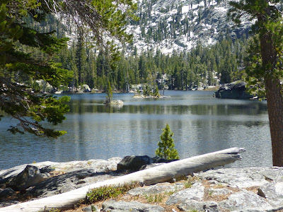
Crag Lake with Crag Peak, seen on a TYT hike in May 2013Along the northernmost section of the Tahoe-Yosemite Trail (TYT) in the North Desolation Wilderness a string of scenic lakes, locally known as the Tallant Lakes, are accessible via a moderate-to-difficult hike up the TYT trail from Meeks Bay, Lake Tahoe, California [1-3]. The first alpine lake, you are arriving at by climbing up for about 4.6 miles from the Meeks Bay trailhead, is Lake Genevieve. Then, after a short walk, Crag Lake and Crag Peak with its granite walls and slopes are coming into view, about five miles away from the Meeks Bay trailhead.

On a sunny and warm May day, Crag Lake can still make a winter-landscape impression. But during summer months, the shallow lake is good for fishing and swimming. Then, like other Sierra lakes— for example, Nevada's Rock Lake south of Slide Mountain—Crag Lake displays yellow water lilies with their floating leaves [3].     

Getting to the Meeks Bay trailhead next to Highway 89 at Lake Tahoe
See the Getting there description in my previous post TYT: From Meeks Bay to Lake Genevieve.

References and more to explore
[1] Mike White: Afoot & Afield, Reno-Tahoe. Wilderness Press, Berkeley, California, 2nd printing November 2008.
[2] TahoeLoco: Hike of the week: Meeks Bay to Crag Lake [www.tahoeloco.com/archives/3069]. 
[3] The Tahoe to Yosemite Trail: The South Shore of Crag Lake [tahoetowhitney.com/picturetrail/Tahoe_to_Alpine/Meeks_to_Echo_Summit/Crag_Lake_2.html]

Friday, May 24, 2013

Tahoe-Yosemite Trail: From Meeks Bay to Lake Genevieve

Snowplant ring, valley of Meeks Creek, California


Lake Genevieve, a greenish, shallow lake in the Desolation Wilderness, CaliforniaThe Tahoe-Yosemite Trail (TYT) is a 185-mile-long path that starts at Lake Tahoe's Meeks Bay and ends at Tuolumne Meadows in Yosemite—all in California. The trail is named after the title of a hiking guidebook written by Thomas Winnett [1]. The trail has difficult parts, with sections not so easy to find and follow. Locally it takes you to over 10,000 feet. Not so its northern most stretch between Meeks Bay and Lake Genevieve (right picture). This beautiful section mostly follows Meeks Creek, rushing water you always hear (at least, during spring months), but may not always see. The valley of Meeks Creek is a landscape of bogs and alpine meadows surrounded by pine and cedar forest and granite walls. Snow plants, as shown above, can be found here in spring. Around this time, corn lily shoots with their characteristically veined, bright green leaves are emerging at several places.

At one point, you'll cross Meeks Creek on a narrow, two-beam bridge without any handrails. A steady climb will get you to a three-way junction marked by a post, 4.6 miles from the Meeks Bay trailhead. Lake Genevieve is already in view and you have several options to venture forward; in Mike White's words [2]:
The old Lake Genevieve Trail to the right [of the post at the TYT] is a seldom-used lateral that connects to the General Creek and Pacific Crest trails. Just beyond the junction is Lake Genevieve, a greenish, shallow lake rimmed by pines. A number of fair campsites are spread around the far shoreline, but more appealing sites with better scenery are just a short distance up the trail, at Crag Lake.

Notice that a permit is required to stay overnight. Sign-in forms are available at the Meeks Bay trailhead.

Getting there
The Meeks Bay trailhead is located next to Highway 89 (eleven miles south of Tahoe City), south of Sugar Pine Point State Park and north of D. L. Bliss State Park. There are a few scattered parking lots along the west side of the road. At the trail gate you'll find an information board with a map; a section of which is shown below. However, during my last visit this May, I couldn't find any hints that this is the beginning of the Tahoe-Yosemite Trail. Obviously, the TYT is not an officially endorsed or maintained trail. But the section between Meeks Bay and the first string of alpine lakes in the Desolation Wilderness is well maintained and easy to follow trail. This scenic trail starts out as an old dirt road and contues as a single-track trail—an outstanding hiking trail comparable with or even superior to other trail gems around Lake Tahoe. 

Nearby trails and attractions south of Meeks Bay

Tahoe-Yosemite Trail (TYT) hiking map, as posted at Meeks Bay trailhead

References and more to explore
[1] Tahoe Yosemite Trail [outhiking.com/ty%20index.html].
[2] Mike White: Afoot & Afield, Reno-Tahoe. Wilderness Press, Berkeley, California, 2nd printing November 2008.

Tuesday, May 21, 2013

Lower Eagle Falls near Vikingsholm Mansion, Emerald Bay State Park, California

Lower Eagle Falls near Vikingsholm Castle, Lake Tohoe, California

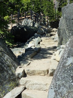
Stairs along Lower Eagle Falls TrailSpring is a great time to visit Lake Tahoe's Emerald Bay and the historic Vikingsholm Castle site. While you are waiting for your tour of the castle (available seven days a week from Memorial Day weekend until the end of September), you may want to hang out at the beach or climb up the short forest trail to the Lower Eagle Falls. The snowmelt water from the Desolation Wilderness is cascading down the falls into Emerald Bay. On a hot day you will enjoy the refreshing spray. Halfway up to the falls viewing deck, a bridge (see picture to the right) is crossing the running water, leaving Lower Eagle Falls Trail and continuing as a trail along the south side of Emerald Bay. If you are ready to do a longer hike along the bay and above Lake Tahoe's deep blue water, Rubicon Trail should be your choice. This trail leads north into neighboring D. L. Bliss State Park with its little Lighthouse and the Balancing Rock Nature Trail

Getting there
Find parking near the granite precipice overlooking Emerald Bay, east of the Emerald Bay Road section of Highway 89. Next to the granite overlook, a broad, but steep one-mile-long trail descends down into the bay, offering scenic views of the surrounding mountains, Ponderosa and Jeffrey pine forest and Fannette Island. After a few switchbacks you will arrive at the shady bottom of the “Emerald Bay Canyon,” where the Vikingsholm Mansion is located. The nearby visitor center is the starting point of the single-track Lower Eagle Falls Trail.  

Tuesday, May 14, 2013

Incense cedar (Calocedrus decurrens) of David's Grove in Reno

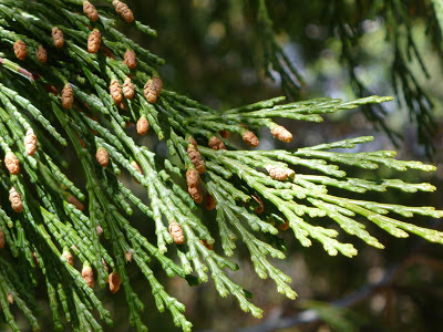
Branch of an incense cedar (Calocedrus decurrens) with tiny pollen cones
The incense cedar (Calocedrus decurrens) is a coniferous tree of the western United States and northwest Mexico [1,2]. The shown branches and bark belong to a tall tree in David's Grove of the Wilbur D. May Arboretum and Botanical Garden in Reno, Washoe County, Nevada. Other names for this tree species of the cypress family (Cupressaceae) are white, bastard, and California post cedar, for which Donald Culross Peattie gives the following range description [1]:

Cinnamon pink bark at lower trunk of an incense cedar (Calocedrus decurrens)
Both east and west slopes of the Cascade Range in Oregon, from the foothills to 6600 feet, and south through the Sierra Nevada, and Coast Ranges of California (3000 to 9700 feet) to the Sierra San Pedro Mártir in Baja California. Also in Washoe County, Nevada.

The evergreen trees show a bright green foliage of scale-leaves. The tiny yellowish brown pollen cones at the branch tips can be seen in the picture. The bark at the lower trunk is grayish pink to cinnamon red. Exfoliation of the bark as brittle plates and long strips becomes common for older trees. If you happen to find a cedar with charcoal-colored bark on the trunk—like being scorched, the darkened bark may be caused by growth of sooty mold (Arthrobotryum spongiosum), a non-pathogenic fungus [3].  

Keywords: botany, trees, evergreens, cypress family (Cupressaceae).

References and more to explore
[1] Donald Culross Peattie: A Natural History of North American Trees. Houghton Mifflin Company, New York, 2007 (originally published in 1950 and 1953).
[2] USDA Plants Profile: Calocedrus decurrens (Torr.) Florin [plants.usda.gov/java/profile?symbol=CADE27].
[3] MyMotherload:  Incense Cedar Scales [www.mymotherlode.com/news/local/2069306/Incense-Cedar-Scales-.html].

Wednesday, May 1, 2013

Wilbur D. May Arboretum and Botanical Garden Trails, Reno, Nevada

Map of the Wilbur D. May Arboretum and Botanical Garden, Reno, Nevada
The Wilbur D. May Arboretum and Botanical Garden is a Washoe County Regional Park in north Reno. This park is situated between the Sierra Nevada Mountains and the Great Basin Desert, southeast of Mt. Peavine: a transitional zone in a high desert environment with an arid climate. The arboretum and garden provides opportunities for education, research and for pleasure [1-3]. The nonprofit May Arboretum Society organizes events and workshops.

The park is a mosaic of gardens and groves interconnected by a network of walkways and tiny trails. It includes a Native Garden, a Songbird Garden and a Xeriscape to explore and showcase landscaping and gardening with no or little irrigation. Benches can be found in some hidden and shady areas. Informative panels have been placed at selected sites to introduce botanists, plants and historical subjects of local interest. 

Getting there
The Wilbur D. May Arboretum and Botanical Garden belong to the Wilbur D. May Center in Rancho San Rafael Regional Park at 1595 North Sierra Street, Reno, Nevada. North Sierra St. is running parallel to North Virginia Street between Interstate 80 (Lincoln Highway) and North McCarran Blvd. From North Sierra St., turn west on Putnam Drive, which continues as San Rafael Drive. There is a parking area in front of the park and the Wilbur D. May Museum. The park has various entrances, for example north of the museum, between the Park Office and the Arboretum Office as well as on the eastern side of the Ranch House, from where a trail leads downhill to the riparian habitat along Evans Creek and the Arboretum Loop. Following Evans Creek in northwest direction you'll get to Herman's Pond, on the left side of the trail. Uphill to your right is a gazebo and the Irwin Overlook. From the pond you may want to continue on to and through the McCarran underpass to get to the Basque Sheepherder Monument, the Ranch Disc Golf Course, the cottonwood grove Nature Trail and many other hiking and mountain biking trails along creeks, canyons and across the Peavine foothills. 

The public park is open from sunrise to sunset.

Keywords: park trails, botany, horticulture, high desert.

References and more to explore
[1] Wilbur D. May Arboretum and Society, Reno, Nevada [trailingahead.blogspot.com/2012/02/wilbur-d-may-arboretum-and-society-reno.html].
[2] Washoe County Nevada >  May Arboretum [www.washoecounty.us/parks/arboretum/arbor.html].
[3] MuseumsUSA: Wilbur D. May Arboretum and Botanical Garden [www.museumsusa.org/museums/info/13252].